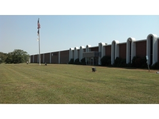
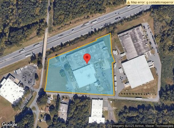
Property Record
3145 Northwest Blvd, Gastonia, NC 28052


NEARBY LISTINGS FOR SALE OR LEASE
Property Detail
3145 Northwest Blvd
137110
Radicispandex Corp
Industrialgeneral
10 028 017 00 000
X
Gaston
3710353600J
North Carolina
2024
8.79 AC
2024
Gaston County
031500
Charlotte
128,778 SF
Charlotte-Concord-Gastonia, NC-SC
DEMOGRAPHICS near 3145 Northwest Blvd
1 Mile
3 Mile
5 Mile
2024 Total Population
2,601
33,628
83,740
2029 Population
2,804
36,029
89,475
Pop Growth 2024-2029
+ 7.80%
+ 7.14%
+ 6.85%
Average Age
38
38
39
2024 Total Households
1,021
13,087
33,271
HH Growth 2024-2029
+ 7.93%
+ 7.30%
+ 7.00%
Median Household Inc
$24,109
$38,551
$43,327
Avg Household Size
2.40
2.40
2.40
2024 Avg HH Vehicles
1.00
2.00
2.00
Median Home Value
$90,983
$154,572
$166,107
Median Year Built
1959
1967
1973
Nearby Places
- Restaurants
- Banks
- Shops
- Fitness
- Groceries
PUBLIC TRANSPORTATION
COMMUTER RAIL
Gastonia Amtrak Station (Crescent - Amtrak)
DRIVE
WALK
Distance
Gastonia Amtrak Station (Crescent - Amtrak)
10 min
6.3 mi
AIRPORT
Charlotte/Douglas International
DRIVE
WALK
Distance
Charlotte/Douglas International
35 min
21.1 mi
Concord-Padgett Regional
DRIVE
WALK
Distance
Concord-Padgett Regional
49 min
37.4 mi
Freight Ports
North Charleston Terminal
DRIVE
WALK
Distance
North Charleston Terminal
249 min
207.4 mi
Nearby Properties
Address
Land Use
TOTAL SIZE
Lot Size
Zoning
Address
Land Use
TOTAL SIZE
Lot Size
Zoning
56,000 SF
23.22 AC
GOV01
Address
Land Use
TOTAL SIZE
Lot Size
Zoning
68.71 AC
Address
Land Use
TOTAL SIZE
Lot Size
Zoning
11,696 SF
159.68 AC
Address
Land Use
TOTAL SIZE
Lot Size
Zoning
4,519 SF
2.10 AC
Address
Land Use
TOTAL SIZE
Lot Size
Zoning
159,263 SF
9.83 AC
GOV01
Address
Land Use
TOTAL SIZE
Lot Size
Zoning
268,563 SF
116.96 AC
MANU1
Address
Land Use
TOTAL SIZE
Lot Size
Zoning
29.89 AC
Address
Land Use
TOTAL SIZE
Lot Size
Zoning
Address
Land Use
TOTAL SIZE
Lot Size
Zoning
312,465 SF
35.23 AC
Address
Land Use
TOTAL SIZE
Lot Size
Zoning
192,315 SF
44.12 AC
INDS1
Address
Land Use
TOTAL SIZE
Lot Size
Zoning
2,250 SF
27.79 AC
OFF01
Address
Land Use
TOTAL SIZE
Lot Size
Zoning
539,988 SF
36.32 AC
STOR6
Address
Land Use
TOTAL SIZE
Lot Size
Zoning
192,978 SF
22.67 AC
RET05
Address
Land Use
TOTAL SIZE
Lot Size
Zoning
123,948 SF
6.94 AC
GOV05
Address
Land Use
TOTAL SIZE
Lot Size
Zoning
411,076 SF
67.01 AC
INDS2
Address
Land Use
TOTAL SIZE
Lot Size
Zoning
176,657 SF
16.19 AC
Address
Land Use
TOTAL SIZE
Lot Size
Zoning
112,513 SF
13.09 AC
PUB01
Address
Land Use
TOTAL SIZE
Lot Size
Zoning
154,681 SF
63.07 AC
INDS1
Address
Land Use
TOTAL SIZE
Lot Size
Zoning
8,412 SF
39.83 AC
PUB01
Address
Land Use
TOTAL SIZE
Lot Size
Zoning
1,760 SF
3.51 AC
Address
Land Use
TOTAL SIZE
Lot Size
Zoning
163,100 SF
41.60 AC
INDS1
Address
Land Use
TOTAL SIZE
Lot Size
Zoning
44,794 SF
46.96 AC
PUB01
Address
Land Use
TOTAL SIZE
Lot Size
Zoning
57,880 SF
5.99 AC
GOV05
Address
Land Use
TOTAL SIZE
Lot Size
Zoning
167,332 SF
19.92 AC
INDS1
Address
Land Use
TOTAL SIZE
Lot Size
Zoning
Address
Land Use
TOTAL SIZE
Lot Size
Zoning
0.79 AC
RET01
Address
Land Use
TOTAL SIZE
Lot Size
Zoning
109,085 SF
1.69 AC
BANK1
Address
Land Use
TOTAL SIZE
Lot Size
Zoning
148,300 SF
12.59 AC
INDS2
Address
Land Use
TOTAL SIZE
Lot Size
Zoning
1,914 SF
15.78 AC
MRKT1
Address
Land Use
TOTAL SIZE
Lot Size
Zoning
105,285 SF
25.27 AC
INDS1
The World's #1 Commercial Real Estate Marketplace
Connect with us
© 2025 CoStar Group
The information above has been obtained from sources believed reliable. While we do not doubt its accuracy we have not verified it and make no guarantee, warranty or representation about it. It is your responsibility to independently confirm its accuracy and completeness. Any projections, opinions, assumptions, or estimates used are for example only and do not represent the current or future performance of the property. The value of this transaction to you depends on tax and other factors which should be evaluated by your tax, financial, and legal advisors. You and your advisors should conduct a careful, independent investigation of the property to determine to your satisfaction the suitability of the property for your needs.