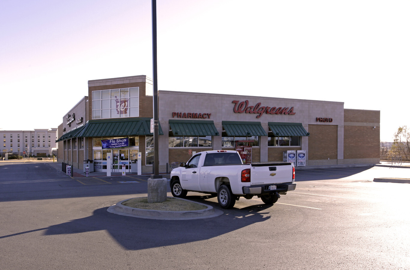
Property Record
315 N 193Rd East Ave, Claremore, OK 74019

NEARBY LISTINGS FOR SALE OR LEASE
Property Detail
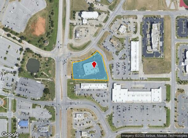
315 N 193Rd East Ave
Tulsa, OK
Shops At The Gathering Ext
660091233
LOT 1 BLOCK 1 SHOPS AT THE GATHERING EXT., THE
Drugstorepharmacycvswalgreens
Rogers
X
Oklahoma
40131C0350J
1
2024
1.80 AC
2024
Rogers County
050101
Tulsa
14,204 SF
DEMOGRAPHICS near 315 N 193Rd East Ave
1 Mile
3 Mile
5 Mile
2024 Total Population
4,285
11,198
44,297
2029 Population
4,723
12,159
47,865
Pop Growth 2024-2029
+ 10.22%
+ 8.58%
+ 8.05%
Average Age
39
39
36
2024 Total Households
1,663
4,345
15,771
HH Growth 2024-2029
+ 10.40%
+ 8.65%
+ 7.99%
Median Household Inc
$57,226
$60,813
$64,748
Avg Household Size
2.50
2.60
2.70
2024 Avg HH Vehicles
2.00
2.00
2.00
Median Home Value
$123,089
$157,081
$162,716
Median Year Built
1976
1980
1985
Nearby Places
- Restaurants
- Banks
- Shops
- Fitness
- Groceries
PUBLIC TRANSPORTATION
AIRPORT
Tulsa International
DRIVE
WALK
Distance
Tulsa International
18 min
12.4 mi
Freight Ports
Tulsa Port Of Catoosa
DRIVE
WALK
Distance
Tulsa Port Of Catoosa
10 min
5.6 mi
Nearby Properties
Address
Land Use
TOTAL SIZE
Lot Size
Zoning
Address
Land Use
TOTAL SIZE
Lot Size
Zoning
39,375 SF
70 AC
AG
Address
Land Use
TOTAL SIZE
Lot Size
Zoning
3,720 SF
158.66 AC
Address
Land Use
TOTAL SIZE
Lot Size
Zoning
6,000 SF
346.13 AC
Address
Land Use
TOTAL SIZE
Lot Size
Zoning
16,250 SF
76.36 AC
AG
Address
Land Use
TOTAL SIZE
Lot Size
Zoning
6,000 SF
1 AC
Address
Land Use
TOTAL SIZE
Lot Size
Zoning
2,842 SF
89.24 AC
AG
Address
Land Use
TOTAL SIZE
Lot Size
Zoning
153,297 SF
16.29 AC
Address
Land Use
TOTAL SIZE
Lot Size
Zoning
62,644 SF
12.38 AC
Address
Land Use
TOTAL SIZE
Lot Size
Zoning
7,584 SF
16.13 AC
AG
Address
Land Use
TOTAL SIZE
Lot Size
Zoning
103,820 SF
2.70 AC
Address
Land Use
TOTAL SIZE
Lot Size
Zoning
2,210 SF
58.48 AC
AG
Address
Land Use
TOTAL SIZE
Lot Size
Zoning
133,875 SF
7.68 AC
Address
Land Use
TOTAL SIZE
Lot Size
Zoning
220,126 SF
16.39 AC
IL
Address
Land Use
TOTAL SIZE
Lot Size
Zoning
14,196 SF
1.75 AC
RS1
Address
Land Use
TOTAL SIZE
Lot Size
Zoning
87,500 SF
4.12 AC
IL
Address
Land Use
TOTAL SIZE
Lot Size
Zoning
12,294 SF
1.57 AC
RS3
Address
Land Use
TOTAL SIZE
Lot Size
Zoning
15,523 SF
7 AC
AG
Address
Land Use
TOTAL SIZE
Lot Size
Zoning
4,279 SF
40 AC
AG
Address
Land Use
TOTAL SIZE
Lot Size
Zoning
58,610 SF
4.07 AC
Address
Land Use
TOTAL SIZE
Lot Size
Zoning
2,456 SF
2.18 AC
Address
Land Use
TOTAL SIZE
Lot Size
Zoning
68,725 SF
2.74 AC
Address
Land Use
TOTAL SIZE
Lot Size
Zoning
1,440 SF
4.84 AC
Address
Land Use
TOTAL SIZE
Lot Size
Zoning
11,115 SF
2.61 AC
RS3
Address
Land Use
TOTAL SIZE
Lot Size
Zoning
450 AC
AG
Address
Land Use
TOTAL SIZE
Lot Size
Zoning
6,568 SF
6.50 AC
RS1
Address
Land Use
TOTAL SIZE
Lot Size
Zoning
9,710 SF
3.91 AC
RS3
Address
Land Use
TOTAL SIZE
Lot Size
Zoning
60,000 SF
11.53 AC
Address
Land Use
TOTAL SIZE
Lot Size
Zoning
35,000 SF
4.54 AC
Address
Land Use
TOTAL SIZE
Lot Size
Zoning
101,980 SF
5.48 AC
CS
Address
Land Use
TOTAL SIZE
Lot Size
Zoning
51,260 SF
19.10 AC
IL
The World's #1 Commercial Real Estate Marketplace
Connect with us
© 2025 CoStar Group
The information above has been obtained from sources believed reliable. While we do not doubt its accuracy we have not verified it and make no guarantee, warranty or representation about it. It is your responsibility to independently confirm its accuracy and completeness. Any projections, opinions, assumptions, or estimates used are for example only and do not represent the current or future performance of the property. The value of this transaction to you depends on tax and other factors which should be evaluated by your tax, financial, and legal advisors. You and your advisors should conduct a careful, independent investigation of the property to determine to your satisfaction the suitability of the property for your needs.