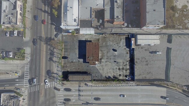
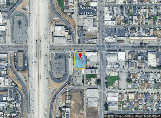
Property Record
316 W Manchester Ave, Los Angeles, CA 90003

NEARBY LISTINGS FOR SALE OR LEASE
Property Detail
316 W Manchester Ave
Los Angeles-Long Beach-Glendale, CA
Scovills Moneta Avenue Tract
6040-014-020
SCOVILLS MONETA AVE TRACT EX OF STS LOT 25 AND EX OF ST LOTS 26 AND 27
Autorepair
Los Angeles
X
California
06037C1785G
25
2024
0.60 AC
2025
Mid-Cities
239702
Los Angeles
1,398 SF
DEMOGRAPHICS near 316 W Manchester Ave
1 Mile
3 Mile
5 Mile
2024 Total Population
64,410
430,965
1,048,691
2029 Population
62,083
413,891
1,005,407
Pop Growth 2024-2029
(3.61%)
(3.96%)
(4.13%)
Average Age
34
35
36
2024 Total Households
16,725
114,184
292,460
HH Growth 2024-2029
(3.89%)
(4.22%)
(4.30%)
Median Household Inc
$42,162
$51,853
$54,494
Avg Household Size
3.60
3.60
3.40
2024 Avg HH Vehicles
2.00
2.00
2.00
Median Home Value
$495,042
$588,865
$628,801
Median Year Built
1954
1950
1953
Nearby Places
Map Layers
Map Styles
 Street
 Aerial
- Restaurants
- Banks
- Shops
- Fitness
- Groceries
PUBLIC TRANSPORTATION
COMMUTER RAIL
DRIVE
WALK
Distance
13 min
8.8 mi
Union Station (91 Line - Southern California Regional Rail Authority (Metrolink), Antelope Valley Line - Southern California Regional Rail Authority (Metrolink), Orange County Line - Southern California Regional Rail Authority (Metrolink), Riverside Line - Southern California Regional Rail Authority (Metrolink), San Bernardino Line - Southern California Regional Rail Authority (Metrolink), Ventura County Line - Southern California Regional Rail Authority (Metrolink))
DRIVE
WALK
Distance
Union Station (91 Line - Southern California Regional Rail Authority (Metrolink), Antelope Valley Line - Southern California Regional Rail Authority (Metrolink), Orange County Line - Southern California Regional Rail Authority (Metrolink), Riverside Line - Southern California Regional Rail Authority (Metrolink), San Bernardino Line - Southern California Regional Rail Authority (Metrolink), Ventura County Line - Southern California Regional Rail Authority (Metrolink))
15 min
9.0 mi
AIRPORT
Los Angeles International
DRIVE
WALK
Distance
Los Angeles International
17 min
8.6 mi
Long Beach (Daugherty Field)
DRIVE
WALK
Distance
Long Beach (Daugherty Field)
23 min
16.3 mi
Bob Hope
DRIVE
WALK
Distance
Bob Hope
32 min
23.9 mi
Freight Ports
Port of Long Beach
DRIVE
WALK
Distance
Port of Long Beach
26 min
18.2 mi
SALE & LEASE HISTORY
LISTING DATE
SALE/LEASE

Jan 10, 2024
For Sale
Feb 21, 2024
For Sale
Dec 19, 2023
For Sale
Nearby Properties
Address
Land Use
TOTAL SIZE
Lot Size
Zoning
Address
Land Use
TOTAL SIZE
Lot Size
Zoning
2,531,696 SF
79.60 AC
INCR*
Address
Land Use
TOTAL SIZE
Lot Size
Zoning
108,598 SF
15.93 AC
LCC3*
Address
Land Use
TOTAL SIZE
Lot Size
Zoning
57,488 SF
4.30 AC
LAPF
Address
Land Use
TOTAL SIZE
Lot Size
Zoning
127,484 SF
7.33 AC
LAM2
Address
Land Use
TOTAL SIZE
Lot Size
Zoning
81,735 SF
4.10 AC
LAR4
Address
Land Use
TOTAL SIZE
Lot Size
Zoning
104,291 SF
7.35 AC
LAR3
Address
Land Use
TOTAL SIZE
Lot Size
Zoning
134,514 SF
1.94 AC
LCM2*
Address
Land Use
TOTAL SIZE
Lot Size
Zoning
103,656 SF
6.98 AC
LCM1
Address
Land Use
TOTAL SIZE
Lot Size
Zoning
293,886 SF
4.98 AC
SGM3
Address
Land Use
TOTAL SIZE
Lot Size
Zoning
402,118 SF
9.39 AC
LAC2
Address
Land Use
TOTAL SIZE
Lot Size
Zoning
111,213 SF
12.04 AC
LAR4
Address
Land Use
TOTAL SIZE
Lot Size
Zoning
188,030 SF
3.09 AC
LAR5
Address
Land Use
TOTAL SIZE
Lot Size
Zoning
101,562 SF
7.53 AC
LAR3
Address
Land Use
TOTAL SIZE
Lot Size
Zoning
52,331 SF
4.17 AC
SG
Address
Land Use
TOTAL SIZE
Lot Size
Zoning
102,260 SF
16.84 AC
LAR4
Address
Land Use
TOTAL SIZE
Lot Size
Zoning
90,887 SF
0.94 AC
LCR320U*
Address
Land Use
TOTAL SIZE
Lot Size
Zoning
152,151 SF
3.59 AC
LCM2*
Address
Land Use
TOTAL SIZE
Lot Size
Zoning
589,061 SF
19.32 AC
SGM3
Address
Land Use
TOTAL SIZE
Lot Size
Zoning
189,808 SF
4.07 AC
LAM2
Address
Land Use
TOTAL SIZE
Lot Size
Zoning
333,054 SF
19.17 AC
INR1*
Address
Land Use
TOTAL SIZE
Lot Size
Zoning
108,496 SF
9.82 AC
LAM2
Address
Land Use
TOTAL SIZE
Lot Size
Zoning
113,733 SF
1.59 AC
LAM2
Address
Land Use
TOTAL SIZE
Lot Size
Zoning
38,567 SF
1.11 AC
LAR3
Address
Land Use
TOTAL SIZE
Lot Size
Zoning
40,065 SF
1.24 AC
LAC2
Address
Land Use
TOTAL SIZE
Lot Size
Zoning
78,505 SF
3.21 AC
HPM2*
Address
Land Use
TOTAL SIZE
Lot Size
Zoning
93,319 SF
1.70 AC
LAM2
Address
Land Use
TOTAL SIZE
Lot Size
Zoning
171,971 SF
5.21 AC
LCM2*
Address
Land Use
TOTAL SIZE
Lot Size
Zoning
44,769 SF
0.84 AC
LAC2
Address
Land Use
TOTAL SIZE
Lot Size
Zoning
75,444 SF
2.98 AC
HPM2YY
Address
Land Use
TOTAL SIZE
Lot Size
Zoning
57,587 SF
5.03 AC
LAM2
The World's #1 Commercial Real Estate Marketplace
Connect with us
© 2026 CoStar Group
The information above has been obtained from sources believed reliable. While we do not doubt its accuracy we have not verified it and make no guarantee, warranty or representation about it. It is your responsibility to independently confirm its accuracy and completeness. Any projections, opinions, assumptions, or estimates used are for example only and do not represent the current or future performance of the property. The value of this transaction to you depends on tax and other factors which should be evaluated by your tax, financial, and legal advisors. You and your advisors should conduct a careful, independent investigation of the property to determine to your satisfaction the suitability of the property for your needs.