Property Record
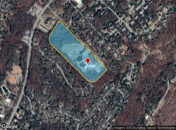
317 Ault Rd, Signal Mountain, TN 37377

NEARBY LISTINGS FOR SALE OR LEASE
Property Detail
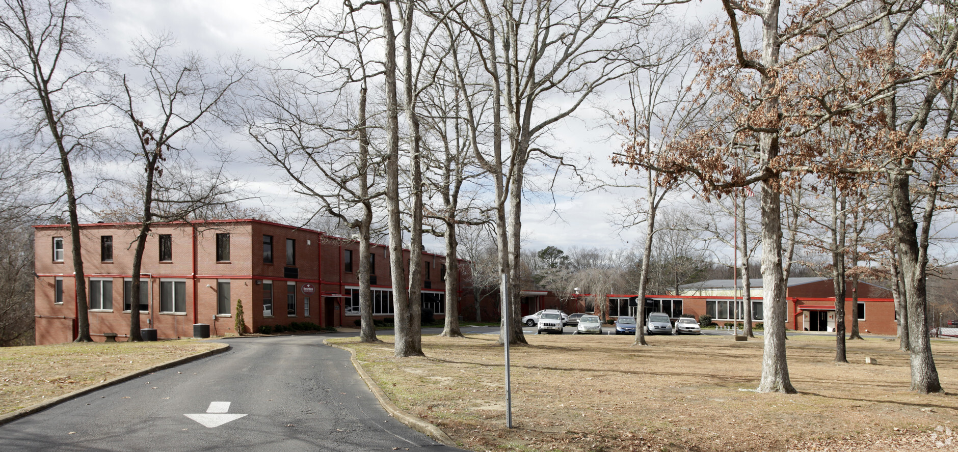
317 Ault Rd
Chattanooga, TN-GA
Final Plat Of Signal Mountain Jr High Sc
108B-A-031
LT 1 SIGNAL MTN JR HIGH SCHOOL PB91 PG188
Gymhealthspa
Hamilton
X
Tennessee
47065C0214G
1
2024
16.29 AC
2024
Outlying Hamilton County
011100
Chattanooga
48,931 SF
DEMOGRAPHICS near 317 Ault Rd
1 Mile
3 Mile
5 Mile
2024 Total Population
3,069
28,657
65,115
2029 Population
3,235
30,633
69,469
Pop Growth 2024-2029
+ 5.41%
+ 6.90%
+ 6.69%
Average Age
42
42
41
2024 Total Households
1,114
12,449
28,556
HH Growth 2024-2029
+ 5.48%
+ 7.24%
+ 6.94%
Median Household Inc
$122,703
$72,048
$72,696
Avg Household Size
2.70
2.20
2.20
2024 Avg HH Vehicles
2.00
2.00
2.00
Median Home Value
$410,949
$300,417
$279,223
Median Year Built
1975
1976
1975
Nearby Places
- Restaurants
- Banks
- Shops
- Fitness
- Groceries
PUBLIC TRANSPORTATION
AIRPORT
Lovell Field
DRIVE
WALK
Distance
Lovell Field
34 min
19.4 mi
Freight Ports
Georgia Ports - Savannah
DRIVE
WALK
Distance
Georgia Ports - Savannah
424 min
374.6 mi
Nearby Properties
Address
Land Use
TOTAL SIZE
Lot Size
Zoning
Address
Land Use
TOTAL SIZE
Lot Size
Zoning
293,884 SF
4.40 AC
Address
Land Use
TOTAL SIZE
Lot Size
Zoning
269,640 SF
15 AC
R1
Address
Land Use
TOTAL SIZE
Lot Size
Zoning
224,655 SF
43.30 AC
R1
Address
Land Use
TOTAL SIZE
Lot Size
Zoning
614,488 SF
28.09 AC
Address
Land Use
TOTAL SIZE
Lot Size
Zoning
1,938 AC
Address
Land Use
TOTAL SIZE
Lot Size
Zoning
15,808 SF
56.70 AC
Address
Land Use
TOTAL SIZE
Lot Size
Zoning
95,584 SF
4.60 AC
A1
Address
Land Use
TOTAL SIZE
Lot Size
Zoning
1,866.70 AC
A
Address
Land Use
TOTAL SIZE
Lot Size
Zoning
206,680 SF
25.11 AC
M1
Address
Land Use
TOTAL SIZE
Lot Size
Zoning
308,440 SF
499.35 AC
M1
Address
Land Use
TOTAL SIZE
Lot Size
Zoning
7,658 SF
28 AC
R1
Address
Land Use
TOTAL SIZE
Lot Size
Zoning
18,478 SF
27 AC
R1
Address
Land Use
TOTAL SIZE
Lot Size
Zoning
185,132 SF
19.85 AC
R1
Address
Land Use
TOTAL SIZE
Lot Size
Zoning
521,879 SF
47.82 AC
M1
Address
Land Use
TOTAL SIZE
Lot Size
Zoning
108,864 SF
13.50 AC
R1
Address
Land Use
TOTAL SIZE
Lot Size
Zoning
77,748 SF
2.30 AC
R1
Address
Land Use
TOTAL SIZE
Lot Size
Zoning
50,781 SF
2.57 AC
A1
Address
Land Use
TOTAL SIZE
Lot Size
Zoning
108,297 SF
12.43 AC
R4
Address
Land Use
TOTAL SIZE
Lot Size
Zoning
258.89 AC
A
Address
Land Use
TOTAL SIZE
Lot Size
Zoning
148,793 SF
11 AC
R1
Address
Land Use
TOTAL SIZE
Lot Size
Zoning
8,216 SF
6.25 AC
A
Address
Land Use
TOTAL SIZE
Lot Size
Zoning
55,696 SF
7.72 AC
M1
Address
Land Use
TOTAL SIZE
Lot Size
Zoning
50,290 SF
3.60 AC
RB
Address
Land Use
TOTAL SIZE
Lot Size
Zoning
92,976 SF
4.20 AC
R3
Address
Land Use
TOTAL SIZE
Lot Size
Zoning
24,917 SF
4.23 AC
Address
Land Use
TOTAL SIZE
Lot Size
Zoning
49,541 SF
5.83 AC
C2
Address
Land Use
TOTAL SIZE
Lot Size
Zoning
12,972 SF
4.80 AC
R3
Address
Land Use
TOTAL SIZE
Lot Size
Zoning
58,386 SF
2.56 AC
R4
Address
Land Use
TOTAL SIZE
Lot Size
Zoning
95,992 SF
6.15 AC
R3
Address
Land Use
TOTAL SIZE
Lot Size
Zoning
77,643 SF
3.98 AC
The World's #1 Commercial Real Estate Marketplace
Connect with us
© 2025 CoStar Group
The information above has been obtained from sources believed reliable. While we do not doubt its accuracy we have not verified it and make no guarantee, warranty or representation about it. It is your responsibility to independently confirm its accuracy and completeness. Any projections, opinions, assumptions, or estimates used are for example only and do not represent the current or future performance of the property. The value of this transaction to you depends on tax and other factors which should be evaluated by your tax, financial, and legal advisors. You and your advisors should conduct a careful, independent investigation of the property to determine to your satisfaction the suitability of the property for your needs.