Property Record
317 W Oglethorpe Blvd, Albany, GA 31701
NEARBY LISTINGS FOR SALE OR LEASE
-
-
-
No Photo
-
-
-
-
-
View all Albany listings for lease on LoopNet.com
Property Detail
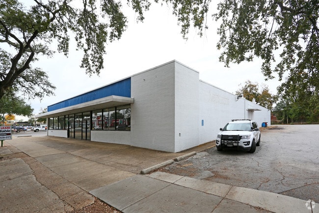
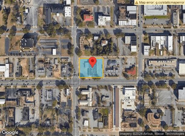
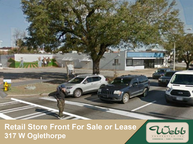
317 W Oglethorpe Blvd
Albany, GA
Albany Historical District
0S301-00006-022
LOTS 63-65-67-69-71 BLK 6
Storebuilding
Dougherty
X
Georgia
13095C0109E
63-65
2024
1.28 AC
2024
Albany/Southwest
011400
Other Market Areas
14,940 SF
DEMOGRAPHICS near 317 W Oglethorpe Blvd
1 Mile
3 Mile
5 Mile
2024 Total Population
4,317
38,296
71,197
2029 Population
4,330
36,881
68,878
Pop Growth 2024-2029
+ 0.30%
(3.69%)
(3.26%)
Average Age
40
38
38
2024 Total Households
2,014
15,652
29,455
HH Growth 2024-2029
+ 0.15%
(3.73%)
(3.45%)
Median Household Inc
$24,492
$33,004
$41,881
Avg Household Size
2.10
2.30
2.30
2024 Avg HH Vehicles
1.00
1.00
1.00
Median Home Value
$70,034
$74,017
$106,282
Median Year Built
1962
1966
1974
Nearby Places
Map Layers
Map Styles
 Street
 Aerial
- Restaurants
- Banks
- Shops
- Fitness
- Groceries
PUBLIC TRANSPORTATION
AIRPORT
Southwest Georgia Regional
DRIVE
WALK
Distance
Southwest Georgia Regional
11 min
4.4 mi
SALE & LEASE HISTORY
LISTING DATE
SALE/LEASE

Oct 26, 2023
For Lease
Oct 12, 2016
For Lease
Oct 12, 2016
For Sale
Jun 26, 2018
For Lease
Jul 15, 2021
For Lease
Jul 15, 2021
For Lease
Jan 29, 2018
For Lease
Aug 01, 2018
For Lease
Apr 24, 2018
For Lease
Nearby Properties
Address
Land Use
TOTAL SIZE
Lot Size
Zoning
Address
Land Use
TOTAL SIZE
Lot Size
Zoning
Address
Land Use
TOTAL SIZE
Lot Size
Zoning
58.86 AC
C3
Address
Land Use
TOTAL SIZE
Lot Size
Zoning
51,008 SF
19.48 AC
C5
Address
Land Use
TOTAL SIZE
Lot Size
Zoning
274,484 SF
16.31 AC
C5
Address
Land Use
TOTAL SIZE
Lot Size
Zoning
1.77 AC
C2
Address
Land Use
TOTAL SIZE
Lot Size
Zoning
15.20 AC
C2
Address
Land Use
TOTAL SIZE
Lot Size
Zoning
2.53 AC
C2
Address
Land Use
TOTAL SIZE
Lot Size
Zoning
1.75 AC
C2
Address
Land Use
TOTAL SIZE
Lot Size
Zoning
0.83 AC
C2
Address
Land Use
TOTAL SIZE
Lot Size
Zoning
141,600 SF
45.43 AC
C1
Address
Land Use
TOTAL SIZE
Lot Size
Zoning
77,688 SF
2.93 AC
C3
Address
Land Use
TOTAL SIZE
Lot Size
Zoning
70,596 SF
2.38 AC
C2
Address
Land Use
TOTAL SIZE
Lot Size
Zoning
232,840 SF
49.88 AC
M1
Address
Land Use
TOTAL SIZE
Lot Size
Zoning
0.54 AC
C2
Address
Land Use
TOTAL SIZE
Lot Size
Zoning
9,676 SF
10.73 AC
R6
Address
Land Use
TOTAL SIZE
Lot Size
Zoning
9.37 AC
C3
Address
Land Use
TOTAL SIZE
Lot Size
Zoning
8 AC
M1
Address
Land Use
TOTAL SIZE
Lot Size
Zoning
204,625 SF
27.28 AC
M1
Address
Land Use
TOTAL SIZE
Lot Size
Zoning
475,976 SF
51.30 AC
M1
Address
Land Use
TOTAL SIZE
Lot Size
Zoning
0.52 AC
C2
Address
Land Use
TOTAL SIZE
Lot Size
Zoning
98,560 SF
19.64 AC
R6
Address
Land Use
TOTAL SIZE
Lot Size
Zoning
82,944 SF
8.10 AC
R6
Address
Land Use
TOTAL SIZE
Lot Size
Zoning
25,777 SF
9.30 AC
C3
Address
Land Use
TOTAL SIZE
Lot Size
Zoning
13,958 SF
15 AC
M1
Address
Land Use
TOTAL SIZE
Lot Size
Zoning
28,713 SF
9.96 AC
C3
Address
Land Use
TOTAL SIZE
Lot Size
Zoning
30,336 SF
19.19 AC
R6
Address
Land Use
TOTAL SIZE
Lot Size
Zoning
5,100 SF
18.93 AC
R6
Address
Land Use
TOTAL SIZE
Lot Size
Zoning
146,281 SF
17.87 AC
M1
Address
Land Use
TOTAL SIZE
Lot Size
Zoning
10,608 SF
45.66 AC
M1
Address
Land Use
TOTAL SIZE
Lot Size
Zoning
127,194 SF
15.01 AC
C2
The World's #1 Commercial Real Estate Marketplace
Connect with us
© 2026 CoStar Group
The information above has been obtained from sources believed reliable. While we do not doubt its accuracy we have not verified it and make no guarantee, warranty or representation about it. It is your responsibility to independently confirm its accuracy and completeness. Any projections, opinions, assumptions, or estimates used are for example only and do not represent the current or future performance of the property. The value of this transaction to you depends on tax and other factors which should be evaluated by your tax, financial, and legal advisors. You and your advisors should conduct a careful, independent investigation of the property to determine to your satisfaction the suitability of the property for your needs.