Property Record
1943 Cox St, Fort Myers, FL 33916
This Property Is For Sale
NEARBY LISTINGS FOR SALE OR LEASE
Property Detail
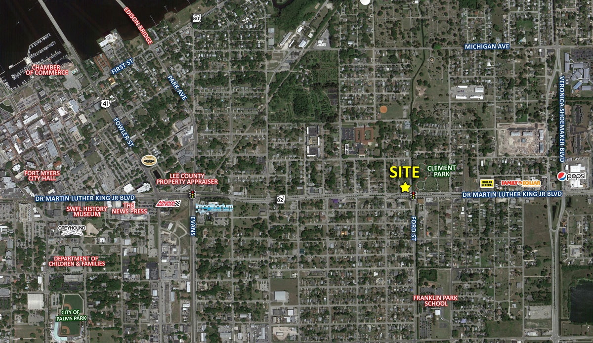
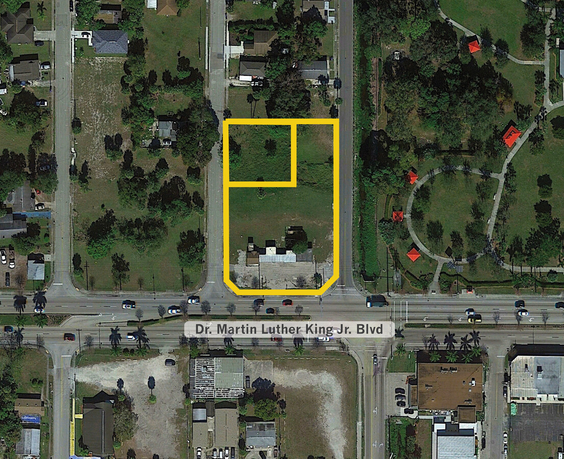
1943 Cox St
Cape Coral-Fort Myers, FL
Palmetto To Prospect N Billy Crk S Of Rr
18-44-25-P4-0090C.0070
Lee
Residentialacreage
Florida
AE
0.24 AC
12071C0288H
City of Ft Myers
984 SF
Southwest Florida
DEMOGRAPHICS near 1943 Cox St
1 Mile
3 Mile
5 Mile
2024 Total Population
9,963
65,803
142,438
2029 Population
11,781
78,023
169,348
Pop Growth 2024-2029
+ 18.25%
+ 18.57%
+ 18.89%
Average Age
38
39
43
2024 Total Households
3,724
26,006
58,963
HH Growth 2024-2029
+ 17.94%
+ 18.50%
+ 18.69%
Median Household Inc
$34,031
$39,859
$50,034
Avg Household Size
2.50
2.30
2.30
2024 Avg HH Vehicles
1.00
1.00
1.00
Median Home Value
$116,473
$195,030
$233,149
Median Year Built
1978
1985
1987
Nearby Places
- Restaurants
- Banks
- Shops
- Fitness
- Groceries
PUBLIC TRANSPORTATION
AIRPORT
Southwest Florida International
DRIVE
WALK
Distance
Southwest Florida International
20 min
12.7 mi
Punta Gorda
DRIVE
WALK
Distance
Punta Gorda
36 min
24.0 mi
Freight Ports
Port Manatee
DRIVE
WALK
Distance
Port Manatee
115 min
95.7 mi
Nearby Properties
Address
Land Use
TOTAL SIZE
Lot Size
Zoning
Address
Land Use
TOTAL SIZE
Lot Size
Zoning
770,753 SF
5.87 AC
PUD
Address
Land Use
TOTAL SIZE
Lot Size
Zoning
536,175 SF
8.42 AC
PO
Address
Land Use
TOTAL SIZE
Lot Size
Zoning
520,572 SF
24.13 AC
CG
Address
Land Use
TOTAL SIZE
Lot Size
Zoning
438,839 SF
66.95 AC
MU
Address
Land Use
TOTAL SIZE
Lot Size
Zoning
646,502 SF
6.11 AC
PUD
Address
Land Use
TOTAL SIZE
Lot Size
Zoning
723,322 SF
1.73 AC
PUD
Address
Land Use
TOTAL SIZE
Lot Size
Zoning
475,045 SF
30.22 AC
PUD
Address
Land Use
TOTAL SIZE
Lot Size
Zoning
429,703 SF
16.24 AC
PUD
Address
Land Use
TOTAL SIZE
Lot Size
Zoning
552,157 SF
4.20 AC
PUD
Address
Land Use
TOTAL SIZE
Lot Size
Zoning
425,658 SF
25.61 AC
CG
Address
Land Use
TOTAL SIZE
Lot Size
Zoning
305,224 SF
17.11 AC
CG
Address
Land Use
TOTAL SIZE
Lot Size
Zoning
368,722 SF
18.09 AC
CG
Address
Land Use
TOTAL SIZE
Lot Size
Zoning
16.13 AC
Address
Land Use
TOTAL SIZE
Lot Size
Zoning
304,258 SF
12.20 AC
CG
Address
Land Use
TOTAL SIZE
Lot Size
Zoning
694,188 SF
22.43 AC
PUD
Address
Land Use
TOTAL SIZE
Lot Size
Zoning
284,371 SF
12.61 AC
CG
Address
Land Use
TOTAL SIZE
Lot Size
Zoning
11.64 AC
C-1
Address
Land Use
TOTAL SIZE
Lot Size
Zoning
243,841 SF
3.16 AC
CIVIC
Address
Land Use
TOTAL SIZE
Lot Size
Zoning
250,169 SF
10.67 AC
CI
Address
Land Use
TOTAL SIZE
Lot Size
Zoning
580,121 SF
61.83 AC
IL
Address
Land Use
TOTAL SIZE
Lot Size
Zoning
211,446 SF
7.81 AC
C1
Address
Land Use
TOTAL SIZE
Lot Size
Zoning
357,679 SF
26.43 AC
PUD
Address
Land Use
TOTAL SIZE
Lot Size
Zoning
163,618 SF
1.32 AC
CIVIC
Address
Land Use
TOTAL SIZE
Lot Size
Zoning
376,949 SF
49.70 AC
RM16
Address
Land Use
TOTAL SIZE
Lot Size
Zoning
13.71 AC
Address
Land Use
TOTAL SIZE
Lot Size
Zoning
333,282 SF
25.70 AC
C1
Address
Land Use
TOTAL SIZE
Lot Size
Zoning
551,003 SF
3.24 AC
PUD
Address
Land Use
TOTAL SIZE
Lot Size
Zoning
319,765 SF
47.40 AC
RS7
Address
Land Use
TOTAL SIZE
Lot Size
Zoning
294,203 SF
30.22 AC
RM16
Address
Land Use
TOTAL SIZE
Lot Size
Zoning
106,300 SF
14.71 AC
TFC2
The World's #1 Commercial Real Estate Marketplace
Connect with us
© 2025 CoStar Group
The information above has been obtained from sources believed reliable. While we do not doubt its accuracy we have not verified it and make no guarantee, warranty or representation about it. It is your responsibility to independently confirm its accuracy and completeness. Any projections, opinions, assumptions, or estimates used are for example only and do not represent the current or future performance of the property. The value of this transaction to you depends on tax and other factors which should be evaluated by your tax, financial, and legal advisors. You and your advisors should conduct a careful, independent investigation of the property to determine to your satisfaction the suitability of the property for your needs.