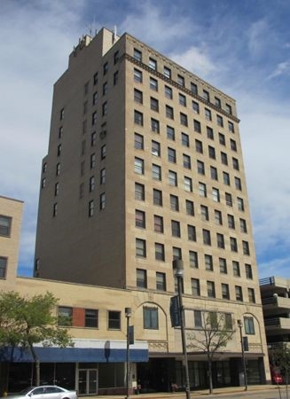
Property Record
319 W State St, Rockford, IL 61101

NEARBY LISTINGS FOR SALE OR LEASE
Property Detail
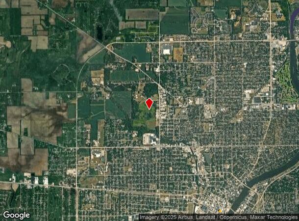
319 W State St
Rockford, IL
West Rockford
11-23-307-007
WEST ROCKFORD E 1/2 LOTS 4 + 005 BLOCK13
Commercialnec
Winnebago
X
Illinois
17201C0263E
4,005
2022
0.25 AC
2022
I-39 Corr/Winnebago Cnty
003601
Chicago
115,095 SF
DEMOGRAPHICS near 319 W State St
1 Mile
3 Mile
5 Mile
2024 Total Population
14,442
89,219
155,008
2029 Population
14,678
88,760
153,512
Pop Growth 2024-2029
+ 1.63%
(0.51%)
(0.97%)
Average Age
37
37
39
2024 Total Households
6,146
35,616
62,333
HH Growth 2024-2029
+ 1.33%
(0.61%)
(1.03%)
Median Household Inc
$23,512
$37,947
$44,296
Avg Household Size
2.10
2.40
2.40
2024 Avg HH Vehicles
1.00
1.00
2.00
Median Home Value
$70,501
$76,301
$99,413
Median Year Built
1948
1952
1959
Nearby Places
- Restaurants
- Banks
- Shops
- Fitness
- Groceries
PUBLIC TRANSPORTATION
AIRPORT
Chicago/Rockford International
DRIVE
WALK
Distance
Chicago/Rockford International
21 min
10.4 mi
Freight Ports
Port Milwaukee
DRIVE
WALK
Distance
Port Milwaukee
116 min
91.9 mi
SALE & LEASE HISTORY
LISTING DATE
SALE/LEASE

Sep 25, 2016
For Lease
Oct 01, 2019
For Lease
Mar 01, 2017
For Lease
Jan 30, 2022
For Lease
Feb 05, 2020
For Lease
Dec 16, 2022
For Lease
Nearby Properties
Address
Land Use
TOTAL SIZE
Lot Size
Zoning
Address
Land Use
TOTAL SIZE
Lot Size
Zoning
256,236 SF
29.33 AC
R3
Address
Land Use
TOTAL SIZE
Lot Size
Zoning
216,540 SF
22 AC
C3
Address
Land Use
TOTAL SIZE
Lot Size
Zoning
201,507 SF
C4
Address
Land Use
TOTAL SIZE
Lot Size
Zoning
111,491 SF
0.32 AC
C4
Address
Land Use
TOTAL SIZE
Lot Size
Zoning
117,360 SF
1.52 AC
R4
Address
Land Use
TOTAL SIZE
Lot Size
Zoning
151,517 SF
7.52 AC
R3
Address
Land Use
TOTAL SIZE
Lot Size
Zoning
79,318 SF
1.55 AC
C4
Address
Land Use
TOTAL SIZE
Lot Size
Zoning
78,968 SF
13.64 AC
R2
Address
Land Use
TOTAL SIZE
Lot Size
Zoning
58,526 SF
134.42 AC
RE
Address
Land Use
TOTAL SIZE
Lot Size
Zoning
235,511 SF
15.96 AC
R3
Address
Land Use
TOTAL SIZE
Lot Size
Zoning
243,057 SF
C2
Address
Land Use
TOTAL SIZE
Lot Size
Zoning
6.89 AC
RE
Address
Land Use
TOTAL SIZE
Lot Size
Zoning
57,888 SF
R2
Address
Land Use
TOTAL SIZE
Lot Size
Zoning
44,213 SF
12.04 AC
R2
Address
Land Use
TOTAL SIZE
Lot Size
Zoning
108,233 SF
0.34 AC
C4
Address
Land Use
TOTAL SIZE
Lot Size
Zoning
106,134 SF
8.54 AC
R3
Address
Land Use
TOTAL SIZE
Lot Size
Zoning
104,873 SF
0.71 AC
C4
Address
Land Use
TOTAL SIZE
Lot Size
Zoning
153,461 SF
19.35 AC
I2
Address
Land Use
TOTAL SIZE
Lot Size
Zoning
77,936 SF
1.71 AC
C4
Address
Land Use
TOTAL SIZE
Lot Size
Zoning
63,952 SF
10.70 AC
R2
Address
Land Use
TOTAL SIZE
Lot Size
Zoning
83,110 SF
5.30 AC
R3
Address
Land Use
TOTAL SIZE
Lot Size
Zoning
239,792 SF
0.25 AC
C4
Address
Land Use
TOTAL SIZE
Lot Size
Zoning
95,774 SF
8.06 AC
C2
Address
Land Use
TOTAL SIZE
Lot Size
Zoning
645,384 SF
25.22 AC
I1
Address
Land Use
TOTAL SIZE
Lot Size
Zoning
309,606 SF
18.84 AC
I2
Address
Land Use
TOTAL SIZE
Lot Size
Zoning
133,645 SF
5.51 AC
R4
Address
Land Use
TOTAL SIZE
Lot Size
Zoning
51,571 SF
6.41 AC
R2
Address
Land Use
TOTAL SIZE
Lot Size
Zoning
47,424 SF
6.94 AC
R2
Address
Land Use
TOTAL SIZE
Lot Size
Zoning
106,038 SF
11.99 AC
CG
The World's #1 Commercial Real Estate Marketplace
Connect with us
© 2025 CoStar Group
The information above has been obtained from sources believed reliable. While we do not doubt its accuracy we have not verified it and make no guarantee, warranty or representation about it. It is your responsibility to independently confirm its accuracy and completeness. Any projections, opinions, assumptions, or estimates used are for example only and do not represent the current or future performance of the property. The value of this transaction to you depends on tax and other factors which should be evaluated by your tax, financial, and legal advisors. You and your advisors should conduct a careful, independent investigation of the property to determine to your satisfaction the suitability of the property for your needs.