Property Record
3190 W State Route 89A, Sedona, AZ 86336
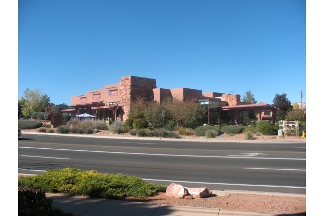


Property Detail
3190 W State Route 89A
408-11-082A
IRREG PCL BY M&B LYNG 888.90 W OF THE NE COR & BEING IN THE NW4 NE4 NE4 CONT 1.67AC SEC 15 17 5E
Stripcommercialcenter
Yavapai
B and X Area of moderate flood hazard, usually the area between the limits of the 100-year and 500-year floods.
Arizona
2025
1.66 AC
2027
Prescott & Sedona
001803
Other Market Areas
13,155 SF
Prescott, AZ
NEARBY LISTINGS FOR SALE OR LEASE
DEMOGRAPHICS near 3190 W State Route 89A
1 mile
3 mile
5 mile
2025 Total Population
3,695
10,106
13,197
2030 Population
3,950
10,734
13,994
Pop Growth 2025-2030
+ 6.90%
+ 6.21%
+ 6.04%
Average Age
54
56
57
2025 Total Households
1,762
5,103
6,695
HH Growth 2025-2030
+ 6.98%
+ 6.07%
+ 5.83%
Median Household Inc
$69,267
$70,650
$68,789
Avg Household Size
2.10
1.90
1.90
2025 Avg HH Vehicles
2.00
2.00
2.00
Median Home Value
$823,037
$805,902
$825,714
Median Year Built
1988
1989
1988
Nearby Places
Map Layers
Map Styles
 Street
 Aerial
Layers
 Traffic
 Biking
Places
Listings with unknown addresses are not visible on the map
- Restaurants
- Banks
- Shops
- Fitness
- Groceries
PUBLIC TRANSPORTATION
AIRPORT
Flagstaff Pulliam
Drive
Walk
Distance
Flagstaff Pulliam
56 min
28.9 mi
SALE & LEASE HISTORY
LISTING DATE
SALE/LEASE

Sep 25, 2016
For Lease
Nearby Properties
Address
Land Use
TOTAL SIZE
Lot Size
Zoning
Address
Land Use
TOTAL SIZE
Lot Size
Zoning
1 SF
23.98 AC
Address
Land Use
TOTAL SIZE
Lot Size
Zoning
151,483 SF
18.75 AC
Address
Land Use
TOTAL SIZE
Lot Size
Zoning
93,897 SF
20.08 AC
Address
Land Use
TOTAL SIZE
Lot Size
Zoning
71,333 SF
4.70 AC
Address
Land Use
TOTAL SIZE
Lot Size
Zoning
79,245 SF
4.33 AC
Address
Land Use
TOTAL SIZE
Lot Size
Zoning
69,838 SF
3.83 AC
Address
Land Use
TOTAL SIZE
Lot Size
Zoning
109,033 SF
11.36 AC
Address
Land Use
TOTAL SIZE
Lot Size
Zoning
97,885 SF
10.15 AC
Address
Land Use
TOTAL SIZE
Lot Size
Zoning
42,483 SF
2.47 AC
Address
Land Use
TOTAL SIZE
Lot Size
Zoning
31,064 SF
4.24 AC
Address
Land Use
TOTAL SIZE
Lot Size
Zoning
20,143 SF
4.42 AC
Address
Land Use
TOTAL SIZE
Lot Size
Zoning
42,008 SF
4.99 AC
Address
Land Use
TOTAL SIZE
Lot Size
Zoning
44,792 SF
3.69 AC
Address
Land Use
TOTAL SIZE
Lot Size
Zoning
26,135 SF
5.36 AC
Address
Land Use
TOTAL SIZE
Lot Size
Zoning
33,373 SF
3.33 AC
Address
Land Use
TOTAL SIZE
Lot Size
Zoning
22,132 SF
1.23 AC
Address
Land Use
TOTAL SIZE
Lot Size
Zoning
20,404 SF
1.12 AC
Address
Land Use
TOTAL SIZE
Lot Size
Zoning
1 SF
24.02 AC
Address
Land Use
TOTAL SIZE
Lot Size
Zoning
27,684 SF
1.61 AC
Address
Land Use
TOTAL SIZE
Lot Size
Zoning
29,769 SF
2.33 AC
Address
Land Use
TOTAL SIZE
Lot Size
Zoning
18.01 AC
Address
Land Use
TOTAL SIZE
Lot Size
Zoning
27,176 SF
1.77 AC
Address
Land Use
TOTAL SIZE
Lot Size
Zoning
10,489 SF
0.73 AC
Address
Land Use
TOTAL SIZE
Lot Size
Zoning
17.98 AC
Address
Land Use
TOTAL SIZE
Lot Size
Zoning
12,780 SF
5.28 AC
Address
Land Use
TOTAL SIZE
Lot Size
Zoning
29,691 SF
2.66 AC
Address
Land Use
TOTAL SIZE
Lot Size
Zoning
57,544 SF
2.70 AC
Address
Land Use
TOTAL SIZE
Lot Size
Zoning
14,686 SF
4.32 AC
Address
Land Use
TOTAL SIZE
Lot Size
Zoning
20,012 SF
1.57 AC
Address
Land Use
TOTAL SIZE
Lot Size
Zoning
24,650 SF
2.14 AC
The World's #1 Commercial Real Estate Marketplace
Connect with us
© 2026 CoStar Group
The information above has been obtained from sources believed reliable. While we do not doubt its accuracy we have not verified it and make no guarantee, warranty or representation about it. It is your responsibility to independently confirm its accuracy and completeness. Any projections, opinions, assumptions, or estimates used are for example only and do not represent the current or future performance of the property. The value of this transaction to you depends on tax and other factors which should be evaluated by your tax, financial, and legal advisors. You and your advisors should conduct a careful, independent investigation of the property to determine to your satisfaction the suitability of the property for your needs.