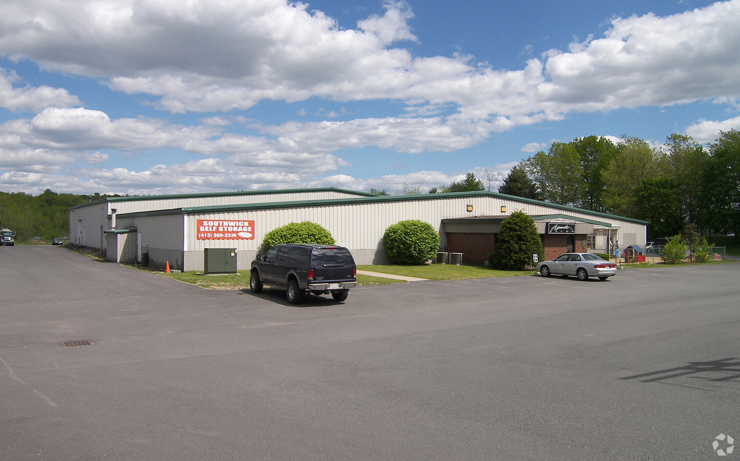
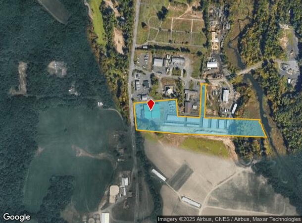
Property Record
320 College Hwy, Southwick, MA 01077
NEARBY LISTINGS FOR SALE OR LEASE
-
-
View all Southwick listings for sale on LoopNet.com
Property Detail
320 College Hwy
SWIC-000126-000000-000001
Hampden
Commercialbuilding
Massachusetts
AE
1
25013C0366E
9.20 AC
2025
Hampden County
2025
Hartford
813101
Springfield, MA
31,216 SF
DEMOGRAPHICS near 320 College Hwy
1 Mile
3 Mile
5 Mile
2024 Total Population
555
9,497
25,578
2029 Population
547
9,400
25,276
Pop Growth 2024-2029
(1.44%)
(1.02%)
(1.18%)
Average Age
44
44
44
2024 Total Households
219
3,879
10,225
HH Growth 2024-2029
(1.83%)
(1.11%)
(1.26%)
Median Household Inc
$103,448
$104,287
$106,790
Avg Household Size
2.50
2.40
2.50
2024 Avg HH Vehicles
3.00
2.00
2.00
Median Home Value
$376,363
$360,789
$332,995
Median Year Built
1983
1976
1975
Nearby Places
- Restaurants
- Banks
- Shops
- Fitness
- Groceries
PUBLIC TRANSPORTATION
AIRPORT
Bradley International
DRIVE
WALK
Distance
Bradley International
32 min
13.6 mi
Freight Ports
Port of New Haven
DRIVE
WALK
Distance
Port of New Haven
84 min
57.0 mi
Nearby Properties
Address
Land Use
TOTAL SIZE
Lot Size
Zoning
Address
Land Use
TOTAL SIZE
Lot Size
Zoning
92,866 SF
32 AC
R20A
Address
Land Use
TOTAL SIZE
Lot Size
Zoning
185,556 SF
64 AC
R-20A
Address
Land Use
TOTAL SIZE
Lot Size
Zoning
4,628 SF
16.01 AC
R-20
Address
Land Use
TOTAL SIZE
Lot Size
Zoning
27,730 SF
17 AC
BR
Address
Land Use
TOTAL SIZE
Lot Size
Zoning
51,608 SF
6.43 AC
IR
Address
Land Use
TOTAL SIZE
Lot Size
Zoning
63,175 SF
4.39 AC
IR
Address
Land Use
TOTAL SIZE
Lot Size
Zoning
2,684 SF
17 AC
BR
Address
Land Use
TOTAL SIZE
Lot Size
Zoning
57,159 SF
7.07 AC
B
Address
Land Use
TOTAL SIZE
Lot Size
Zoning
10,114 SF
33 AC
BR
Address
Land Use
TOTAL SIZE
Lot Size
Zoning
2,183 SF
5.59 AC
BR
Address
Land Use
TOTAL SIZE
Lot Size
Zoning
76.24 AC
IR
Address
Land Use
TOTAL SIZE
Lot Size
Zoning
5,501 SF
7.70 AC
R-20
Address
Land Use
TOTAL SIZE
Lot Size
Zoning
41,885 SF
4.13 AC
IR
Address
Land Use
TOTAL SIZE
Lot Size
Zoning
45,840 SF
3.46 AC
B
Address
Land Use
TOTAL SIZE
Lot Size
Zoning
22,620 SF
5.90 AC
BR
Address
Land Use
TOTAL SIZE
Lot Size
Zoning
40,636 SF
2.40 AC
IR
Address
Land Use
TOTAL SIZE
Lot Size
Zoning
17,016 SF
6.03 AC
BR
Address
Land Use
TOTAL SIZE
Lot Size
Zoning
11,304 SF
0.52 AC
BR
Address
Land Use
TOTAL SIZE
Lot Size
Zoning
12,847 SF
2.25 AC
B
Address
Land Use
TOTAL SIZE
Lot Size
Zoning
9,574 SF
5.80 AC
R-40
Address
Land Use
TOTAL SIZE
Lot Size
Zoning
21,200 SF
3 AC
BR
Address
Land Use
TOTAL SIZE
Lot Size
Zoning
1,819 SF
3.45 AC
B
Address
Land Use
TOTAL SIZE
Lot Size
Zoning
10,655 SF
1.43 AC
BR
Address
Land Use
TOTAL SIZE
Lot Size
Zoning
10,900 SF
6.97 AC
NC
Address
Land Use
TOTAL SIZE
Lot Size
Zoning
3,058 SF
244 AC
R-40
Address
Land Use
TOTAL SIZE
Lot Size
Zoning
35,478 SF
3.10 AC
BR
Address
Land Use
TOTAL SIZE
Lot Size
Zoning
9,992 SF
31.41 AC
R-40
Address
Land Use
TOTAL SIZE
Lot Size
Zoning
7,225 SF
4.06 AC
BR
Address
Land Use
TOTAL SIZE
Lot Size
Zoning
2.20 AC
NC
The World's #1 Commercial Real Estate Marketplace
Connect with us
© 2025 CoStar Group
The information above has been obtained from sources believed reliable. While we do not doubt its accuracy we have not verified it and make no guarantee, warranty or representation about it. It is your responsibility to independently confirm its accuracy and completeness. Any projections, opinions, assumptions, or estimates used are for example only and do not represent the current or future performance of the property. The value of this transaction to you depends on tax and other factors which should be evaluated by your tax, financial, and legal advisors. You and your advisors should conduct a careful, independent investigation of the property to determine to your satisfaction the suitability of the property for your needs.