Property Record
320 W Highland Dr, Lakeland, FL 33813


NEARBY LISTINGS FOR SALE OR LEASE
Property Detail
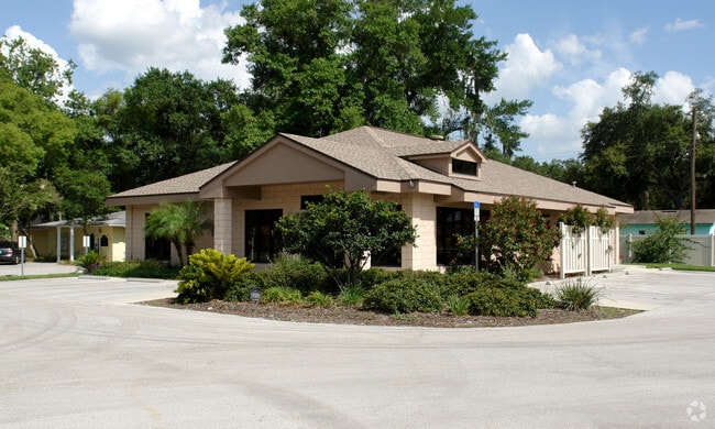
320 W Highland Dr
23-29-01-000000-022340
Alamo Co
Medicalbuilding
W 130 FT OF E 291.42 FT OF N1/2 OF N1/2 OF NW1/4 OF SE1/4 OF SE1/4 LESS MAINT R/W ALONG N SIDE THEREOF
X
Polk
12105C0480G
Florida
2024
0.44 AC
2025
Polk County
011901
Tampa/St Petersburg
2,760 SF
Lakeland-Winter Haven, FL
DEMOGRAPHICS near 320 W Highland Dr
1 Mile
3 Mile
5 Mile
2024 Total Population
6,745
57,981
149,482
2029 Population
7,959
68,817
177,768
Pop Growth 2024-2029
+ 18.00%
+ 18.69%
+ 18.92%
Average Age
41
42
40
2024 Total Households
2,676
23,797
57,730
HH Growth 2024-2029
+ 17.94%
+ 18.67%
+ 19.19%
Median Household Inc
$69,339
$72,152
$64,126
Avg Household Size
2.50
2.40
2.40
2024 Avg HH Vehicles
2.00
2.00
2.00
Median Home Value
$231,631
$253,800
$233,815
Median Year Built
1977
1981
1983
Nearby Places
Map Layers
Map Styles
 Street
 Aerial
- Restaurants
- Banks
- Shops
- Fitness
- Groceries
PUBLIC TRANSPORTATION
COMMUTER RAIL
DRIVE
WALK
Distance
11 min
4.5 mi
AIRPORT
Tampa International
DRIVE
WALK
Distance
Tampa International
56 min
41.6 mi
Freight Ports
Port of Tampa Bay
DRIVE
WALK
Distance
Port of Tampa Bay
48 min
35.9 mi
Nearby Properties
Address
Land Use
TOTAL SIZE
Lot Size
Zoning
Address
Land Use
TOTAL SIZE
Lot Size
Zoning
315,901 SF
20.55 AC
Address
Land Use
TOTAL SIZE
Lot Size
Zoning
364,518 SF
23.38 AC
Address
Land Use
TOTAL SIZE
Lot Size
Zoning
363,147 SF
76.15 AC
Address
Land Use
TOTAL SIZE
Lot Size
Zoning
277,272 SF
19.35 AC
RA4
Address
Land Use
TOTAL SIZE
Lot Size
Zoning
341,795 SF
37.28 AC
Address
Land Use
TOTAL SIZE
Lot Size
Zoning
432,087 SF
626.03 AC
PUD
Address
Land Use
TOTAL SIZE
Lot Size
Zoning
333,560 SF
44.88 AC
IND
Address
Land Use
TOTAL SIZE
Lot Size
Zoning
132,716 SF
20.62 AC
Address
Land Use
TOTAL SIZE
Lot Size
Zoning
202,378 SF
14.39 AC
PUD
Address
Land Use
TOTAL SIZE
Lot Size
Zoning
218,162 SF
16.32 AC
MF12
Address
Land Use
TOTAL SIZE
Lot Size
Zoning
77,358 SF
8.34 AC
PUD
Address
Land Use
TOTAL SIZE
Lot Size
Zoning
242,284 SF
22.90 AC
C4
Address
Land Use
TOTAL SIZE
Lot Size
Zoning
148,182 SF
24.15 AC
Address
Land Use
TOTAL SIZE
Lot Size
Zoning
63,740 SF
8.63 AC
Address
Land Use
TOTAL SIZE
Lot Size
Zoning
106,312 SF
22.64 AC
RC
Address
Land Use
TOTAL SIZE
Lot Size
Zoning
162,990 SF
11.47 AC
MF16
Address
Land Use
TOTAL SIZE
Lot Size
Zoning
128,382 SF
6.42 AC
MF22
Address
Land Use
TOTAL SIZE
Lot Size
Zoning
106,000 SF
15.35 AC
RA3
Address
Land Use
TOTAL SIZE
Lot Size
Zoning
76,527 SF
17.51 AC
R1
Address
Land Use
TOTAL SIZE
Lot Size
Zoning
101,103 SF
13.87 AC
Address
Land Use
TOTAL SIZE
Lot Size
Zoning
160,914 SF
8.72 AC
MF22
Address
Land Use
TOTAL SIZE
Lot Size
Zoning
147,718 SF
52.29 AC
PUD
Address
Land Use
TOTAL SIZE
Lot Size
Zoning
77,232 SF
0.46 AC
Address
Land Use
TOTAL SIZE
Lot Size
Zoning
80,208 SF
4.33 AC
Address
Land Use
TOTAL SIZE
Lot Size
Zoning
56,920 SF
5.39 AC
PUD
Address
Land Use
TOTAL SIZE
Lot Size
Zoning
70,604 SF
7.79 AC
Address
Land Use
TOTAL SIZE
Lot Size
Zoning
149,240 SF
12.54 AC
C4
Address
Land Use
TOTAL SIZE
Lot Size
Zoning
149,602 SF
13.36 AC
Address
Land Use
TOTAL SIZE
Lot Size
Zoning
119,901 SF
8.46 AC
Address
Land Use
TOTAL SIZE
Lot Size
Zoning
97,599 SF
5.11 AC
The World's #1 Commercial Real Estate Marketplace
Connect with us
© 2025 CoStar Group
The information above has been obtained from sources believed reliable. While we do not doubt its accuracy we have not verified it and make no guarantee, warranty or representation about it. It is your responsibility to independently confirm its accuracy and completeness. Any projections, opinions, assumptions, or estimates used are for example only and do not represent the current or future performance of the property. The value of this transaction to you depends on tax and other factors which should be evaluated by your tax, financial, and legal advisors. You and your advisors should conduct a careful, independent investigation of the property to determine to your satisfaction the suitability of the property for your needs.