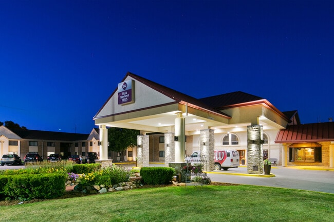
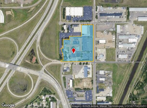
Property Record
3200 W Maple St, Sioux Falls, SD 57107
NEARBY LISTINGS FOR SALE OR LEASE
Property Detail
3200 W Maple St
Sioux Falls, SD
Ramkota Addn
29975
TRACT 3 (EX LOT H1) (INDUSTRIAL BOND) RAMKOTA ADDN & LOT B OF LOT H2 LOT 2 (EX H2) & LOTS 1, 1A, 2 (EX LOT H2) & 2A REPLAT OF
Hotel
Minnehaha
X
South Dakota
46083C0050D
b,2,1
2024
9.65 AC
2024
Sioux Falls
010405
Other Market Areas
168,359 SF
DEMOGRAPHICS near 3200 W Maple St
1 Mile
3 Mile
5 Mile
2024 Total Population
2,295
39,942
117,172
2029 Population
2,518
43,270
126,939
Pop Growth 2024-2029
+ 9.72%
+ 8.33%
+ 8.34%
Average Age
33
37
38
2024 Total Households
949
17,197
49,281
HH Growth 2024-2029
+ 10.01%
+ 8.98%
+ 8.82%
Median Household Inc
$67,720
$54,496
$61,018
Avg Household Size
2.30
2.10
2.20
2024 Avg HH Vehicles
2.00
2.00
2.00
Median Home Value
$247,115
$165,384
$214,976
Median Year Built
2008
1981
1979
Nearby Places
Map Layers
Map Styles
 Street
 Aerial
- Restaurants
- Banks
- Shops
- Fitness
- Groceries
PUBLIC TRANSPORTATION
AIRPORT
Joe Foss Field
DRIVE
WALK
Distance
Joe Foss Field
18 min
4.1 mi
Freight Ports
Port Milwaukee
DRIVE
WALK
Distance
Port Milwaukee
548 min
505.2 mi
Nearby Properties
Address
Land Use
TOTAL SIZE
Lot Size
Zoning
Address
Land Use
TOTAL SIZE
Lot Size
Zoning
80,415 SF
13.13 AC
Address
Land Use
TOTAL SIZE
Lot Size
Zoning
8.90 AC
C1;NEIGHBO
Address
Land Use
TOTAL SIZE
Lot Size
Zoning
Address
Land Use
TOTAL SIZE
Lot Size
Zoning
Address
Land Use
TOTAL SIZE
Lot Size
Zoning
9.41 AC
Address
Land Use
TOTAL SIZE
Lot Size
Zoning
14,820 SF
80.57 AC
FP;FP
Address
Land Use
TOTAL SIZE
Lot Size
Zoning
3.07 AC
FP;FP
Address
Land Use
TOTAL SIZE
Lot Size
Zoning
193,993 SF
34.68 AC
Address
Land Use
TOTAL SIZE
Lot Size
Zoning
1.32 AC
FP;FP
Address
Land Use
TOTAL SIZE
Lot Size
Zoning
1.57 AC
C2;GENERAL
Address
Land Use
TOTAL SIZE
Lot Size
Zoning
72,553 SF
0.97 AC
Address
Land Use
TOTAL SIZE
Lot Size
Zoning
1.20 AC
FP;FP
Address
Land Use
TOTAL SIZE
Lot Size
Zoning
Address
Land Use
TOTAL SIZE
Lot Size
Zoning
3,254 SF
2.13 AC
Address
Land Use
TOTAL SIZE
Lot Size
Zoning
77,853 SF
10.42 AC
Address
Land Use
TOTAL SIZE
Lot Size
Zoning
36,986 SF
8.49 AC
FP;FP
Address
Land Use
TOTAL SIZE
Lot Size
Zoning
140,816 SF
13.80 AC
Address
Land Use
TOTAL SIZE
Lot Size
Zoning
35,688 SF
8.27 AC
FP;FP
Address
Land Use
TOTAL SIZE
Lot Size
Zoning
149,520 SF
22.50 AC
Address
Land Use
TOTAL SIZE
Lot Size
Zoning
75,786 SF
7.14 AC
Address
Land Use
TOTAL SIZE
Lot Size
Zoning
173,235 SF
10 AC
Address
Land Use
TOTAL SIZE
Lot Size
Zoning
137,651 SF
22.28 AC
Address
Land Use
TOTAL SIZE
Lot Size
Zoning
146,718 SF
1.65 AC
Address
Land Use
TOTAL SIZE
Lot Size
Zoning
2.26 AC
FP;FP
Address
Land Use
TOTAL SIZE
Lot Size
Zoning
47,142 SF
6.09 AC
Address
Land Use
TOTAL SIZE
Lot Size
Zoning
49.45 AC
C;COMMERCI
Address
Land Use
TOTAL SIZE
Lot Size
Zoning
18.37 AC
Address
Land Use
TOTAL SIZE
Lot Size
Zoning
167,162 SF
17.11 AC
Address
Land Use
TOTAL SIZE
Lot Size
Zoning
21,060 SF
6.70 AC
FP;FP
The World's #1 Commercial Real Estate Marketplace
Connect with us
© 2025 CoStar Group
The information above has been obtained from sources believed reliable. While we do not doubt its accuracy we have not verified it and make no guarantee, warranty or representation about it. It is your responsibility to independently confirm its accuracy and completeness. Any projections, opinions, assumptions, or estimates used are for example only and do not represent the current or future performance of the property. The value of this transaction to you depends on tax and other factors which should be evaluated by your tax, financial, and legal advisors. You and your advisors should conduct a careful, independent investigation of the property to determine to your satisfaction the suitability of the property for your needs.