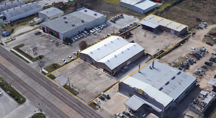
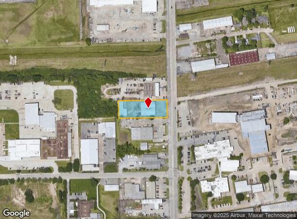
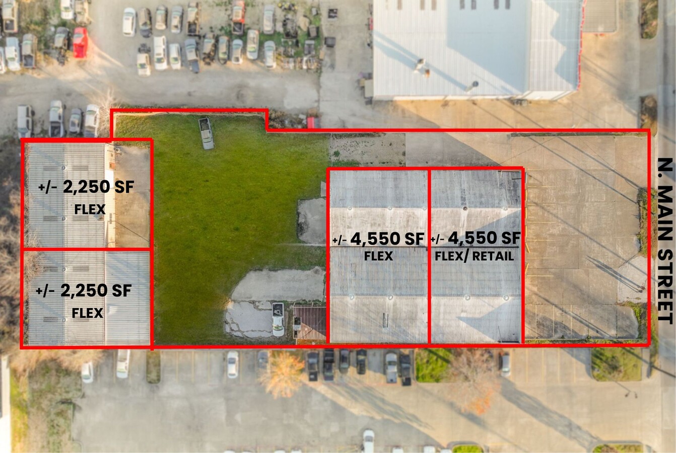
Property Record
3215 N Main St, Baytown, TX 77521

NEARBY LISTINGS FOR SALE OR LEASE
Property Detail
3215 N Main St
0451440020080
Abst 840 H Whiting
Warehouse
TR 1J-2 ABST 840 H WHITING
X
Harris
48201C0765M
Texas
2023
0.96 AC
2023
East-Southeast Far
253700
Houston
13,600 SF
Houston-The Woodlands-Sugar Land, TX
DEMOGRAPHICS near 3215 N Main St
1 Mile
3 Mile
5 Mile
2024 Total Population
13,969
69,064
106,418
2029 Population
14,447
71,049
111,101
Pop Growth 2024-2029
+ 3.42%
+ 2.87%
+ 4.40%
Average Age
35
36
36
2024 Total Households
4,880
24,676
36,685
HH Growth 2024-2029
+ 3.50%
+ 2.78%
+ 4.27%
Median Household Inc
$51,868
$52,457
$58,716
Avg Household Size
2.70
2.70
2.80
2024 Avg HH Vehicles
2.00
2.00
2.00
Median Home Value
$161,978
$161,133
$177,767
Median Year Built
1982
1981
1986
Nearby Places
- Restaurants
- Banks
- Shops
- Fitness
- Groceries
PUBLIC TRANSPORTATION
AIRPORT
William P Hobby
DRIVE
WALK
Distance
William P Hobby
43 min
28.9 mi
George Bush Intcntl/Houston
DRIVE
WALK
Distance
George Bush Intcntl/Houston
45 min
36.0 mi
Freight Ports
Port of Houston
DRIVE
WALK
Distance
Port of Houston
34 min
23.8 mi
SALE & LEASE HISTORY
LISTING DATE
SALE/LEASE

Nov 23, 2020
For Lease
Nov 23, 2020
For Sale
Nov 02, 2021
For Lease
Jun 13, 2024
For Lease
Jul 27, 2023
For Sale
Nearby Properties
Address
Land Use
TOTAL SIZE
Lot Size
Zoning
Address
Land Use
TOTAL SIZE
Lot Size
Zoning
815.98 AC
Address
Land Use
TOTAL SIZE
Lot Size
Zoning
1,019.77 AC
Address
Land Use
TOTAL SIZE
Lot Size
Zoning
Address
Land Use
TOTAL SIZE
Lot Size
Zoning
857.55 AC
Address
Land Use
TOTAL SIZE
Lot Size
Zoning
1,019 AC
Address
Land Use
TOTAL SIZE
Lot Size
Zoning
Address
Land Use
TOTAL SIZE
Lot Size
Zoning
816.17 AC
Address
Land Use
TOTAL SIZE
Lot Size
Zoning
383,631 SF
22.45 AC
Address
Land Use
TOTAL SIZE
Lot Size
Zoning
874.07 AC
Address
Land Use
TOTAL SIZE
Lot Size
Zoning
816.17 AC
Address
Land Use
TOTAL SIZE
Lot Size
Zoning
323,413 SF
26.41 AC
Address
Land Use
TOTAL SIZE
Lot Size
Zoning
251,498 SF
16.36 AC
Address
Land Use
TOTAL SIZE
Lot Size
Zoning
352,067 SF
19.78 AC
Address
Land Use
TOTAL SIZE
Lot Size
Zoning
284,794 SF
10.18 AC
Address
Land Use
TOTAL SIZE
Lot Size
Zoning
209,703 SF
11.18 AC
Address
Land Use
TOTAL SIZE
Lot Size
Zoning
313,810 SF
20 AC
Address
Land Use
TOTAL SIZE
Lot Size
Zoning
225,497 SF
10.90 AC
Address
Land Use
TOTAL SIZE
Lot Size
Zoning
103.75 AC
Address
Land Use
TOTAL SIZE
Lot Size
Zoning
238,488 SF
13 AC
Address
Land Use
TOTAL SIZE
Lot Size
Zoning
214,627 SF
13.77 AC
Address
Land Use
TOTAL SIZE
Lot Size
Zoning
205,859 SF
10.88 AC
Address
Land Use
TOTAL SIZE
Lot Size
Zoning
313,504 SF
18.76 AC
Address
Land Use
TOTAL SIZE
Lot Size
Zoning
247,218 SF
12.44 AC
Address
Land Use
TOTAL SIZE
Lot Size
Zoning
282,661 SF
14.68 AC
Address
Land Use
TOTAL SIZE
Lot Size
Zoning
454,992 SF
Address
Land Use
TOTAL SIZE
Lot Size
Zoning
103,107 SF
15.62 AC
Address
Land Use
TOTAL SIZE
Lot Size
Zoning
816.17 AC
Address
Land Use
TOTAL SIZE
Lot Size
Zoning
270,282 SF
15.19 AC
Address
Land Use
TOTAL SIZE
Lot Size
Zoning
7.79 AC
Address
Land Use
TOTAL SIZE
Lot Size
Zoning
122,554 SF
12.85 AC
The World's #1 Commercial Real Estate Marketplace
Connect with us
© 2025 CoStar Group
The information above has been obtained from sources believed reliable. While we do not doubt its accuracy we have not verified it and make no guarantee, warranty or representation about it. It is your responsibility to independently confirm its accuracy and completeness. Any projections, opinions, assumptions, or estimates used are for example only and do not represent the current or future performance of the property. The value of this transaction to you depends on tax and other factors which should be evaluated by your tax, financial, and legal advisors. You and your advisors should conduct a careful, independent investigation of the property to determine to your satisfaction the suitability of the property for your needs.