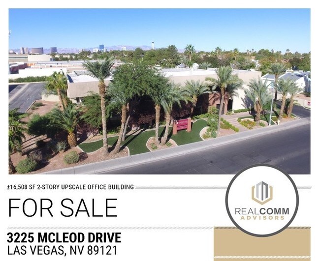
Property Record
3225 Mcleod Dr, Las Vegas, NV 89121


NEARBY LISTINGS FOR SALE OR LEASE
Property Detail
3225 Mcleod Dr
Las Vegas-Henderson-Paradise, NV
Laguna Cove
162-12-417-001
LAGUNA COVE PLAT BOOK 25 PAGE 62 PT LOT 1 BLOCK 1
Commercialnec
Clark
X
Nevada
32003C2190F
1
2025
0.99 AC
2025
Central East Las Vegas
001803
Las Vegas
3,060 SF
DEMOGRAPHICS near 3225 Mcleod Dr
1 Mile
3 Mile
5 Mile
2024 Total Population
19,917
224,255
500,347
2029 Population
21,282
240,294
536,408
Pop Growth 2024-2029
+ 6.85%
+ 7.15%
+ 7.21%
Average Age
41
39
38
2024 Total Households
7,623
91,748
189,766
HH Growth 2024-2029
+ 6.82%
+ 7.18%
+ 7.34%
Median Household Inc
$50,100
$38,488
$41,552
Avg Household Size
2.50
2.40
2.50
2024 Avg HH Vehicles
2.00
1.00
1.00
Median Home Value
$287,866
$267,193
$268,392
Median Year Built
1975
1978
1983
Nearby Places
Map Layers
Map Styles
 Street
 Aerial
- Restaurants
- Banks
- Shops
- Fitness
- Groceries
PUBLIC TRANSPORTATION
AIRPORT
Harry Reid International
DRIVE
WALK
Distance
Harry Reid International
11 min
5.8 mi
Boulder City Municipal
DRIVE
WALK
Distance
Boulder City Municipal
31 min
22.0 mi
SALE & LEASE HISTORY
LISTING DATE
SALE/LEASE

Oct 22, 2018
For Sale
Apr 12, 2018
For Sale
Nearby Properties
Address
Land Use
TOTAL SIZE
Lot Size
Zoning
Address
Land Use
TOTAL SIZE
Lot Size
Zoning
1,172,527 SF
19.67 AC
H1
Address
Land Use
TOTAL SIZE
Lot Size
Zoning
8,805 SF
45.63 AC
Address
Land Use
TOTAL SIZE
Lot Size
Zoning
74,148 SF
18.51 AC
Address
Land Use
TOTAL SIZE
Lot Size
Zoning
323,696 SF
24.62 AC
H1
Address
Land Use
TOTAL SIZE
Lot Size
Zoning
162,214 SF
4.32 AC
Address
Land Use
TOTAL SIZE
Lot Size
Zoning
524,471 SF
59.01 AC
Address
Land Use
TOTAL SIZE
Lot Size
Zoning
48.58 AC
PF
Address
Land Use
TOTAL SIZE
Lot Size
Zoning
265,609 SF
47.36 AC
H1
Address
Land Use
TOTAL SIZE
Lot Size
Zoning
138.07 AC
PF
Address
Land Use
TOTAL SIZE
Lot Size
Zoning
20,924 SF
17.50 AC
H1
Address
Land Use
TOTAL SIZE
Lot Size
Zoning
24,965 SF
25.75 AC
Address
Land Use
TOTAL SIZE
Lot Size
Zoning
281,120 SF
21.38 AC
Address
Land Use
TOTAL SIZE
Lot Size
Zoning
5.96 AC
C2
Address
Land Use
TOTAL SIZE
Lot Size
Zoning
345,133 SF
27.01 AC
H1
Address
Land Use
TOTAL SIZE
Lot Size
Zoning
9.01 AC
PF
Address
Land Use
TOTAL SIZE
Lot Size
Zoning
20.21 AC
H1
Address
Land Use
TOTAL SIZE
Lot Size
Zoning
157,191 SF
5.97 AC
Address
Land Use
TOTAL SIZE
Lot Size
Zoning
549,077 SF
2.90 AC
H1
Address
Land Use
TOTAL SIZE
Lot Size
Zoning
495,267 SF
3.90 AC
H1
Address
Land Use
TOTAL SIZE
Lot Size
Zoning
72.03 AC
PF
Address
Land Use
TOTAL SIZE
Lot Size
Zoning
709,943 SF
43.10 AC
C2
Address
Land Use
TOTAL SIZE
Lot Size
Zoning
17,454 SF
2.51 AC
L:C-2
Address
Land Use
TOTAL SIZE
Lot Size
Zoning
6,396 SF
15.06 AC
Address
Land Use
TOTAL SIZE
Lot Size
Zoning
19,781 SF
5.07 AC
Address
Land Use
TOTAL SIZE
Lot Size
Zoning
8,611 SF
10 AC
H1
Address
Land Use
TOTAL SIZE
Lot Size
Zoning
95,928 SF
3.71 AC
C:U-V
Address
Land Use
TOTAL SIZE
Lot Size
Zoning
239,785 SF
2.20 AC
C:R-5
Address
Land Use
TOTAL SIZE
Lot Size
Zoning
513,085 SF
53.27 AC
C2
Address
Land Use
TOTAL SIZE
Lot Size
Zoning
8,640 SF
4.28 AC
H1
The World's #1 Commercial Real Estate Marketplace
Connect with us
© 2025 CoStar Group
The information above has been obtained from sources believed reliable. While we do not doubt its accuracy we have not verified it and make no guarantee, warranty or representation about it. It is your responsibility to independently confirm its accuracy and completeness. Any projections, opinions, assumptions, or estimates used are for example only and do not represent the current or future performance of the property. The value of this transaction to you depends on tax and other factors which should be evaluated by your tax, financial, and legal advisors. You and your advisors should conduct a careful, independent investigation of the property to determine to your satisfaction the suitability of the property for your needs.