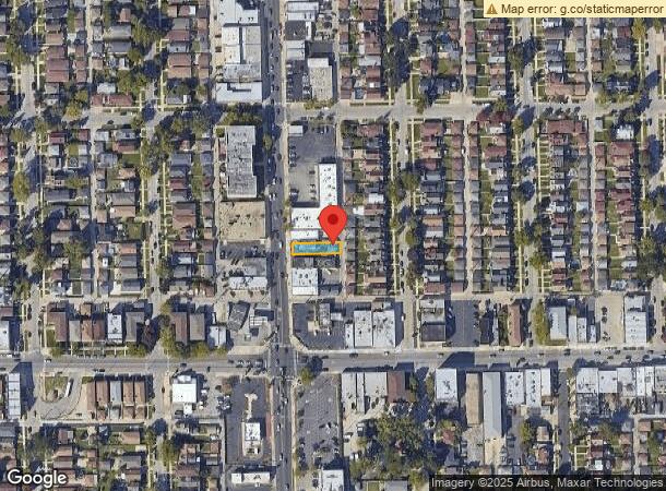
Property Record
3227 N Harlem Ave, Chicago, IL 60634
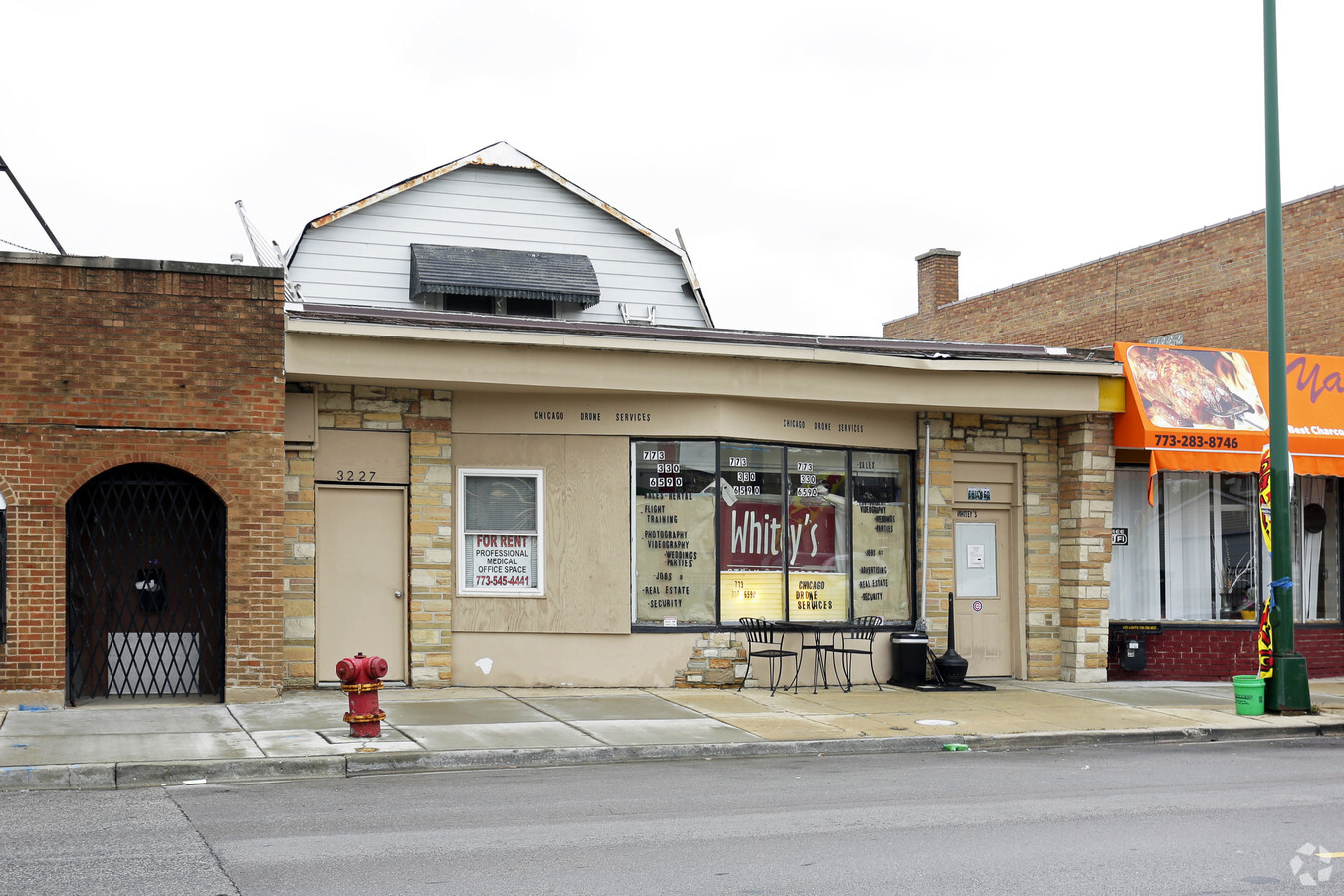

This Property Is For Sale
NEARBY LISTINGS FOR SALE OR LEASE
Property Detail
3227 N Harlem Ave
Chicago-Naperville-Elgin, IL-IN-WI
Stone & Companys Belmont
13-19-326-044-0000
H.O.(STONE) & (COMPANYS)(BELMONT) AVE TERRACE SUB IN WH SW SEC 19-40-13
Miscresidentialimprovement
Cook
X
Illinois
17031C0385J
30,31
2022
0.09 AC
2024
Northwest City
171000
Chicago
2,415 SF
DEMOGRAPHICS near 3227 N Harlem Ave
1 Mile
3 Mile
5 Mile
2024 Total Population
42,618
261,398
693,760
2029 Population
40,722
247,665
657,607
Pop Growth 2024-2029
(4.45%)
(5.25%)
(5.21%)
Average Age
41
41
40
2024 Total Households
15,033
92,939
255,954
HH Growth 2024-2029
(4.74%)
(5.50%)
(5.44%)
Median Household Inc
$74,029
$74,634
$71,716
Avg Household Size
2.80
2.70
2.60
2024 Avg HH Vehicles
2.00
2.00
2.00
Median Home Value
$292,210
$313,069
$323,503
Median Year Built
1951
1950
1949
Nearby Places
- Restaurants
- Banks
- Shops
- Fitness
- Groceries
PUBLIC TRANSPORTATION
COMMUTER RAIL
Mont Clare Station (Milwaukee District West Line - Northeast Illinois Regional Commuter Railroad (Metra), North Central Service - Northeast Illinois Regional Commuter Railroad (Metra))
DRIVE
WALK
Distance
Mont Clare Station (Milwaukee District West Line - Northeast Illinois Regional Commuter Railroad (Metra), North Central Service - Northeast Illinois Regional Commuter Railroad (Metra))
4 min
1.4 mi
Elmwood Park Station (Milwaukee District West Line - Northeast Illinois Regional Commuter Railroad (Metra), North Central Service - Northeast Illinois Regional Commuter Railroad (Metra))
DRIVE
WALK
Distance
Elmwood Park Station (Milwaukee District West Line - Northeast Illinois Regional Commuter Railroad (Metra), North Central Service - Northeast Illinois Regional Commuter Railroad (Metra))
4 min
1.6 mi
AIRPORT
Chicago O'Hare International
DRIVE
WALK
Distance
Chicago O'Hare International
16 min
8.3 mi
Chicago Midway International
DRIVE
WALK
Distance
Chicago Midway International
25 min
13.7 mi
Freight Ports
Port Milwaukee
DRIVE
WALK
Distance
Port Milwaukee
99 min
80.6 mi
Nearby Properties
Address
Land Use
TOTAL SIZE
Lot Size
Zoning
Address
Land Use
TOTAL SIZE
Lot Size
Zoning
422,063 SF
18.88 AC
Address
Land Use
TOTAL SIZE
Lot Size
Zoning
192,365 SF
21.34 AC
PD 127
Address
Land Use
TOTAL SIZE
Lot Size
Zoning
595,800 SF
9.40 AC
Address
Land Use
TOTAL SIZE
Lot Size
Zoning
897,723 SF
23.04 AC
PMD 15
Address
Land Use
TOTAL SIZE
Lot Size
Zoning
396,650 SF
19.12 AC
Address
Land Use
TOTAL SIZE
Lot Size
Zoning
13.33 AC
PD 127
Address
Land Use
TOTAL SIZE
Lot Size
Zoning
9.90 AC
Address
Land Use
TOTAL SIZE
Lot Size
Zoning
1.04 AC
PD 130
Address
Land Use
TOTAL SIZE
Lot Size
Zoning
6.31 AC
PD 1013
Address
Land Use
TOTAL SIZE
Lot Size
Zoning
277,819 SF
10.58 AC
PD 127
Address
Land Use
TOTAL SIZE
Lot Size
Zoning
194,219 SF
17.26 AC
Address
Land Use
TOTAL SIZE
Lot Size
Zoning
548,206 SF
21.13 AC
Address
Land Use
TOTAL SIZE
Lot Size
Zoning
3.33 AC
PD 1013
Address
Land Use
TOTAL SIZE
Lot Size
Zoning
325,045 SF
13.79 AC
Address
Land Use
TOTAL SIZE
Lot Size
Zoning
Address
Land Use
TOTAL SIZE
Lot Size
Zoning
126,955 SF
13.70 AC
PD 541
Address
Land Use
TOTAL SIZE
Lot Size
Zoning
531,227 SF
18.32 AC
Address
Land Use
TOTAL SIZE
Lot Size
Zoning
215,507 SF
6.50 AC
B3-1
Address
Land Use
TOTAL SIZE
Lot Size
Zoning
138,042 SF
11.74 AC
PD 127
Address
Land Use
TOTAL SIZE
Lot Size
Zoning
Address
Land Use
TOTAL SIZE
Lot Size
Zoning
71,133 SF
7.28 AC
PD 441
Address
Land Use
TOTAL SIZE
Lot Size
Zoning
176,076 SF
10.60 AC
Address
Land Use
TOTAL SIZE
Lot Size
Zoning
348,133 SF
2.69 AC
Address
Land Use
TOTAL SIZE
Lot Size
Zoning
141,095 SF
9.15 AC
PD 127
Address
Land Use
TOTAL SIZE
Lot Size
Zoning
Address
Land Use
TOTAL SIZE
Lot Size
Zoning
152,533 SF
12.64 AC
Address
Land Use
TOTAL SIZE
Lot Size
Zoning
95,614 SF
4.20 AC
Address
Land Use
TOTAL SIZE
Lot Size
Zoning
65,243 SF
3.70 AC
Address
Land Use
TOTAL SIZE
Lot Size
Zoning
65,647 SF
5.69 AC
PD 127
Address
Land Use
TOTAL SIZE
Lot Size
Zoning
172,750 SF
5.37 AC
PMD 15
The World's #1 Commercial Real Estate Marketplace
Connect with us
© 2025 CoStar Group
The information above has been obtained from sources believed reliable. While we do not doubt its accuracy we have not verified it and make no guarantee, warranty or representation about it. It is your responsibility to independently confirm its accuracy and completeness. Any projections, opinions, assumptions, or estimates used are for example only and do not represent the current or future performance of the property. The value of this transaction to you depends on tax and other factors which should be evaluated by your tax, financial, and legal advisors. You and your advisors should conduct a careful, independent investigation of the property to determine to your satisfaction the suitability of the property for your needs.