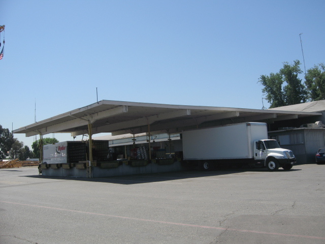
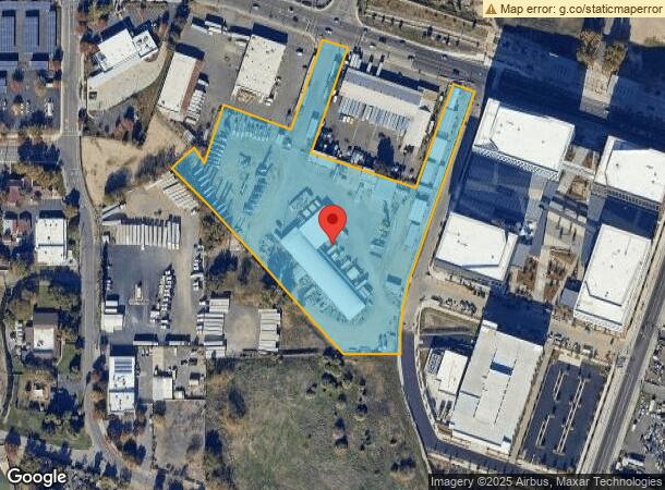
Property Record
325 N 5Th St, Sacramento, CA 95811
NEARBY LISTINGS FOR SALE OR LEASE
Property Detail
325 N 5Th St
001-0210-050
POR OF 103.79 AC PARCEL OF LAND IN CITY OF SACRAMENTO, CA DESIN DEED DATED 4-9-28 FR ENGLISH ESTATE CO TO S.P. CO
Transportnec
Sacramento
X
California
06067C0176J
7.17 AC
2023
Richards
2024
Sacramento
005301
Sacramento--Roseville--Arden-Arcade, CA
25,385 SF
DEMOGRAPHICS near 325 N 5Th St
1 Mile
3 Mile
5 Mile
2024 Total Population
11,405
162,762
358,774
2029 Population
11,558
165,032
363,175
Pop Growth 2024-2029
+ 1.34%
+ 1.39%
+ 1.23%
Average Age
40
38
38
2024 Total Households
3,501
67,175
140,819
HH Growth 2024-2029
+ 2.86%
+ 1.62%
+ 1.35%
Median Household Inc
$31,076
$69,990
$72,139
Avg Household Size
1.70
2.20
2.40
2024 Avg HH Vehicles
1.00
2.00
2.00
Median Home Value
$588,298
$461,216
$475,015
Median Year Built
1978
1973
1972
Nearby Places
- Restaurants
- Banks
- Shops
- Fitness
- Groceries
PUBLIC TRANSPORTATION
TRANSIT/SUBWAY
Township 9 Station (Wb) (13th - Richards/Township 9 - Sacramento Regional Transit)
DRIVE
WALK
Distance
Township 9 Station (Wb) (13th - Richards/Township 9 - Sacramento Regional Transit)
0 min
7 min
0.3 mi
AIRPORT
Sacramento International
DRIVE
WALK
Distance
Sacramento International
16 min
10.3 mi
Freight Ports
Port of Stockton
DRIVE
WALK
Distance
Port of Stockton
56 min
47.9 mi
SALE & LEASE HISTORY
LISTING DATE
SALE/LEASE

Sep 16, 2021
For Lease
Jun 30, 2020
For Lease
Aug 19, 2024
For Lease
Nearby Properties
Address
Land Use
TOTAL SIZE
Lot Size
Zoning
Address
Land Use
TOTAL SIZE
Lot Size
Zoning
1,095,507 SF
1.39 AC
C-2-SPD H-
Address
Land Use
TOTAL SIZE
Lot Size
Zoning
5.64 AC
C-3-SPD
Address
Land Use
TOTAL SIZE
Lot Size
Zoning
10.28 AC
H
Address
Land Use
TOTAL SIZE
Lot Size
Zoning
487,483 SF
1.12 AC
C-3-SPD
Address
Land Use
TOTAL SIZE
Lot Size
Zoning
594,942 SF
2.39 AC
C-3-SPD
Address
Land Use
TOTAL SIZE
Lot Size
Zoning
1,095,507 SF
1.39 AC
C-2-SPD H-
Address
Land Use
TOTAL SIZE
Lot Size
Zoning
405,074 SF
2.39 AC
C-3-SPD
Address
Land Use
TOTAL SIZE
Lot Size
Zoning
399,626 SF
2.41 AC
C-3-SPD
Address
Land Use
TOTAL SIZE
Lot Size
Zoning
200,616 SF
2.54 AC
C-2-SPD
Address
Land Use
TOTAL SIZE
Lot Size
Zoning
366,730 SF
0.89 AC
C-3-SPD
Address
Land Use
TOTAL SIZE
Lot Size
Zoning
676,447 SF
1.43 AC
C-3-SPD
Address
Land Use
TOTAL SIZE
Lot Size
Zoning
508,916 SF
0.71 AC
C-3-SPD
Address
Land Use
TOTAL SIZE
Lot Size
Zoning
339,329 SF
6.40 AC
R-5-PUD-SP
Address
Land Use
TOTAL SIZE
Lot Size
Zoning
193,521 SF
0.60 AC
C-3-SPD
Address
Land Use
TOTAL SIZE
Lot Size
Zoning
0.65 AC
C-4-SPD
Address
Land Use
TOTAL SIZE
Lot Size
Zoning
410,420 SF
0.95 AC
C-3-SPD
Address
Land Use
TOTAL SIZE
Lot Size
Zoning
213,557 SF
2.33 AC
C-3-SPD
Address
Land Use
TOTAL SIZE
Lot Size
Zoning
240,548 SF
0.86 AC
C-3-SPD
Address
Land Use
TOTAL SIZE
Lot Size
Zoning
401,025 SF
4.59 AC
W-F
Address
Land Use
TOTAL SIZE
Lot Size
Zoning
0.90 AC
C-3-SPD
Address
Land Use
TOTAL SIZE
Lot Size
Zoning
119,055 SF
1.18 AC
C-2-SPD
Address
Land Use
TOTAL SIZE
Lot Size
Zoning
318,616 SF
16.40 AC
R-2B-PUD
Address
Land Use
TOTAL SIZE
Lot Size
Zoning
R-4-PUD C-
Address
Land Use
TOTAL SIZE
Lot Size
Zoning
7.49 AC
WF
Address
Land Use
TOTAL SIZE
Lot Size
Zoning
26,712 SF
1.85 AC
R-5-PUD-SP
Address
Land Use
TOTAL SIZE
Lot Size
Zoning
26,712 SF
1.90 AC
R-5-PUD-SP
Address
Land Use
TOTAL SIZE
Lot Size
Zoning
345,359 SF
15.03 AC
OB-PUD
Address
Land Use
TOTAL SIZE
Lot Size
Zoning
303,254 SF
10.63 AC
OB-PUD
Address
Land Use
TOTAL SIZE
Lot Size
Zoning
246,417 SF
1.19 AC
C-3-SPD
Address
Land Use
TOTAL SIZE
Lot Size
Zoning
368,262 SF
0.72 AC
C-3-SPD
The World's #1 Commercial Real Estate Marketplace
Connect with us
© 2025 CoStar Group
The information above has been obtained from sources believed reliable. While we do not doubt its accuracy we have not verified it and make no guarantee, warranty or representation about it. It is your responsibility to independently confirm its accuracy and completeness. Any projections, opinions, assumptions, or estimates used are for example only and do not represent the current or future performance of the property. The value of this transaction to you depends on tax and other factors which should be evaluated by your tax, financial, and legal advisors. You and your advisors should conduct a careful, independent investigation of the property to determine to your satisfaction the suitability of the property for your needs.