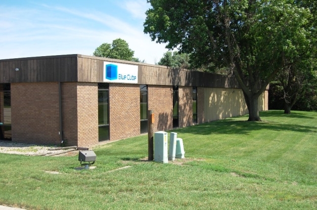
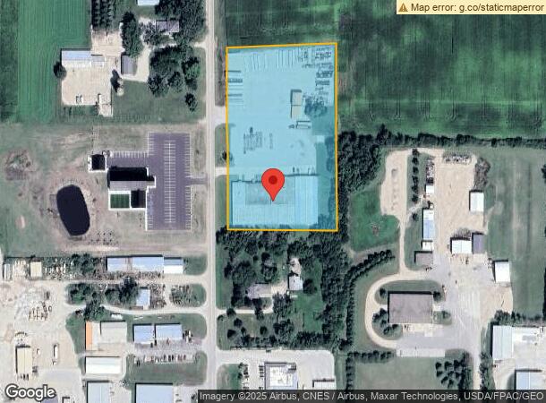
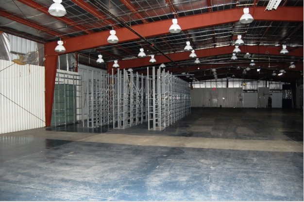
Property Record
325 N State St, Garner, IA 50438
NEARBY LISTINGS FOR SALE OR LEASE
-
-
View all Garner listings for lease on LoopNet.com
Property Detail
325 N State St
Manufacturinglight
30-96-23 TR BEG 1459.65' W & 986.6' S OF NE COR NE 30 96 23
X
Hancock
19081C0326D
Iowa
2023
4.78 AC
2023
Other Market Areas
270100
2150300004
38,726 SF
DEMOGRAPHICS near 325 N State St
1 Mile
3 Mile
5 Mile
2024 Total Population
2,002
3,287
3,593
2029 Population
1,965
3,227
3,526
Pop Growth 2024-2029
(1.85%)
(1.83%)
(1.86%)
Average Age
43
43
43
2024 Total Households
856
1,409
1,536
HH Growth 2024-2029
(1.75%)
(1.77%)
(1.89%)
Median Household Inc
$71,868
$71,760
$71,565
Avg Household Size
2.30
2.30
2.30
2024 Avg HH Vehicles
2.00
2.00
2.00
Median Home Value
$152,891
$150,508
$151,541
Median Year Built
1964
1964
1963
Nearby Places
- Restaurants
- Banks
- Shops
- Fitness
- Groceries
SALE & LEASE HISTORY
LISTING DATE
SALE/LEASE

Sep 25, 2016
For Lease
Sep 23, 2016
For Sale
Nearby Properties
Address
Land Use
TOTAL SIZE
Lot Size
Zoning
Address
Land Use
TOTAL SIZE
Lot Size
Zoning
105,173 SF
23.22 AC
Address
Land Use
TOTAL SIZE
Lot Size
Zoning
50,186 SF
9.01 AC
Address
Land Use
TOTAL SIZE
Lot Size
Zoning
78,518 SF
7.41 AC
Address
Land Use
TOTAL SIZE
Lot Size
Zoning
12,861 SF
1.65 AC
Address
Land Use
TOTAL SIZE
Lot Size
Zoning
268,600 SF
20.56 AC
Address
Land Use
TOTAL SIZE
Lot Size
Zoning
17,684 SF
1.95 AC
Address
Land Use
TOTAL SIZE
Lot Size
Zoning
94,506 SF
5.23 AC
Address
Land Use
TOTAL SIZE
Lot Size
Zoning
7,241 SF
2.61 AC
Address
Land Use
TOTAL SIZE
Lot Size
Zoning
7,200 SF
5 AC
Address
Land Use
TOTAL SIZE
Lot Size
Zoning
1,272 SF
9.35 AC
Address
Land Use
TOTAL SIZE
Lot Size
Zoning
23,853 SF
1.38 AC
Address
Land Use
TOTAL SIZE
Lot Size
Zoning
2,400 SF
3.24 AC
Address
Land Use
TOTAL SIZE
Lot Size
Zoning
9,017 SF
2.26 AC
Address
Land Use
TOTAL SIZE
Lot Size
Zoning
7,912 SF
0.38 AC
Address
Land Use
TOTAL SIZE
Lot Size
Zoning
4,588 SF
5.20 AC
Address
Land Use
TOTAL SIZE
Lot Size
Zoning
16,297 SF
1.73 AC
Address
Land Use
TOTAL SIZE
Lot Size
Zoning
10,463 SF
1.61 AC
Address
Land Use
TOTAL SIZE
Lot Size
Zoning
2,180 SF
7.89 AC
Address
Land Use
TOTAL SIZE
Lot Size
Zoning
41,324 SF
16.04 AC
Address
Land Use
TOTAL SIZE
Lot Size
Zoning
8,772 SF
Address
Land Use
TOTAL SIZE
Lot Size
Zoning
1,295 SF
13.03 AC
Address
Land Use
TOTAL SIZE
Lot Size
Zoning
20,560 SF
6.32 AC
Address
Land Use
TOTAL SIZE
Lot Size
Zoning
5,292 SF
3.60 AC
Address
Land Use
TOTAL SIZE
Lot Size
Zoning
16,461 SF
1.69 AC
Address
Land Use
TOTAL SIZE
Lot Size
Zoning
3.16 AC
Address
Land Use
TOTAL SIZE
Lot Size
Zoning
26,476 SF
1.90 AC
Address
Land Use
TOTAL SIZE
Lot Size
Zoning
2.47 AC
Address
Land Use
TOTAL SIZE
Lot Size
Zoning
0.49 AC
Address
Land Use
TOTAL SIZE
Lot Size
Zoning
2,000 SF
3.40 AC
Address
Land Use
TOTAL SIZE
Lot Size
Zoning
0.80 AC
The World's #1 Commercial Real Estate Marketplace
Connect with us
© 2025 CoStar Group
The information above has been obtained from sources believed reliable. While we do not doubt its accuracy we have not verified it and make no guarantee, warranty or representation about it. It is your responsibility to independently confirm its accuracy and completeness. Any projections, opinions, assumptions, or estimates used are for example only and do not represent the current or future performance of the property. The value of this transaction to you depends on tax and other factors which should be evaluated by your tax, financial, and legal advisors. You and your advisors should conduct a careful, independent investigation of the property to determine to your satisfaction the suitability of the property for your needs.