Property Record
3273 Needles Hwy, Needles, CA 92363
NEARBY LISTINGS FOR SALE OR LEASE
-
-
View all Needles listings for sale on LoopNet.com
Property Detail
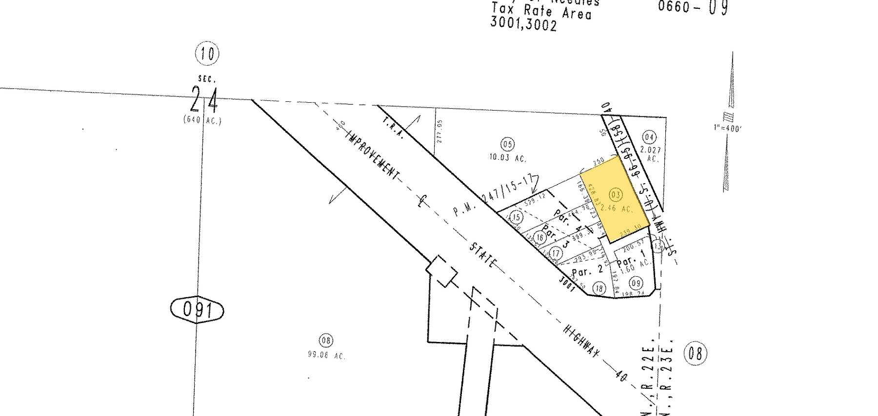
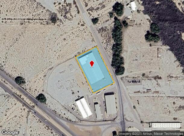
3273 Needles Hwy
0660-091-03
COM AT NE COR SE 1/4 SEC 24 TP 9N R 22E TH S 0 DEG 6 MIN E ALG E LI SD SEC TO PT OF INTERSECTION WITH SWLY LI 100 FT STATE HGWY 66 TH N 26 DEG 20 MIN W ALG SWLY LI SD HGWY 157.74 FT TO TRUE POB TH S 63 DEG 40 MIN W 250 FT TH N 26 DEG 20 MIN W 428.83
Warehouse
San Bernardino
AO
California
04015C5350H
2.46 AC
2023
San Bernardino Outlying
2024
Inland Empire (California)
025100
Riverside-San Bernardino-Ontario, CA
48,384 SF
DEMOGRAPHICS near 3273 Needles Hwy
1 Mile
3 Mile
5 Mile
2024 Total Population
839
9,553
13,483
2029 Population
917
10,280
14,697
Pop Growth 2024-2029
+ 9.30%
+ 7.61%
+ 9.00%
Average Age
50
43
44
2024 Total Households
364
3,865
5,604
HH Growth 2024-2029
+ 9.62%
+ 7.66%
+ 9.48%
Median Household Inc
$56,363
$42,384
$39,420
Avg Household Size
2.30
2.50
2.40
2024 Avg HH Vehicles
2.00
2.00
2.00
Median Home Value
$359,615
$179,722
$207,413
Median Year Built
1987
1986
1985
Nearby Places
- Restaurants
- Banks
- Shops
- Fitness
- Groceries
PUBLIC TRANSPORTATION
COMMUTER RAIL
Needles Amtrak (Southwest Chief - Amtrak)
DRIVE
WALK
Distance
Needles Amtrak (Southwest Chief - Amtrak)
3 min
2.2 mi
AIRPORT
Laughlin/Bullhead International
DRIVE
WALK
Distance
Laughlin/Bullhead International
46 min
26.7 mi
Freight Ports
Port of San Diego
DRIVE
WALK
Distance
Port of San Diego
352 min
319.1 mi
Nearby Properties
Address
Land Use
TOTAL SIZE
Lot Size
Zoning
Address
Land Use
TOTAL SIZE
Lot Size
Zoning
46,499 SF
1.56 AC
Address
Land Use
TOTAL SIZE
Lot Size
Zoning
80,000 SF
4.53 AC
Address
Land Use
TOTAL SIZE
Lot Size
Zoning
46,400 SF
1.60 AC
Address
Land Use
TOTAL SIZE
Lot Size
Zoning
164,720 SF
7.52 AC
Address
Land Use
TOTAL SIZE
Lot Size
Zoning
30,375 SF
14.89 AC
Address
Land Use
TOTAL SIZE
Lot Size
Zoning
46,500 SF
2.17 AC
Address
Land Use
TOTAL SIZE
Lot Size
Zoning
29,181 SF
1.42 AC
Address
Land Use
TOTAL SIZE
Lot Size
Zoning
31,450 SF
2.50 AC
Address
Land Use
TOTAL SIZE
Lot Size
Zoning
20,000 SF
1.87 AC
Address
Land Use
TOTAL SIZE
Lot Size
Zoning
54,291 SF
6.96 AC
Address
Land Use
TOTAL SIZE
Lot Size
Zoning
46,400 SF
21.61 AC
Address
Land Use
TOTAL SIZE
Lot Size
Zoning
24,726 SF
2.15 AC
Address
Land Use
TOTAL SIZE
Lot Size
Zoning
51,234 SF
3.40 AC
Address
Land Use
TOTAL SIZE
Lot Size
Zoning
138,537 SF
6.30 AC
Address
Land Use
TOTAL SIZE
Lot Size
Zoning
4,941 SF
0.52 AC
Address
Land Use
TOTAL SIZE
Lot Size
Zoning
12,400 SF
0.21 AC
Address
Land Use
TOTAL SIZE
Lot Size
Zoning
40,136 SF
4.52 AC
Address
Land Use
TOTAL SIZE
Lot Size
Zoning
69,900 SF
5.89 AC
Address
Land Use
TOTAL SIZE
Lot Size
Zoning
12,500 SF
0.80 AC
Address
Land Use
TOTAL SIZE
Lot Size
Zoning
107,868 SF
13 AC
Address
Land Use
TOTAL SIZE
Lot Size
Zoning
308,000 SF
Address
Land Use
TOTAL SIZE
Lot Size
Zoning
9,100 SF
2.14 AC
Address
Land Use
TOTAL SIZE
Lot Size
Zoning
7,734 SF
16.07 AC
Address
Land Use
TOTAL SIZE
Lot Size
Zoning
6,875 SF
0.41 AC
Address
Land Use
TOTAL SIZE
Lot Size
Zoning
42,840 SF
2.57 AC
Address
Land Use
TOTAL SIZE
Lot Size
Zoning
12,400 SF
0.41 AC
Address
Land Use
TOTAL SIZE
Lot Size
Zoning
21,680 SF
1.72 AC
Address
Land Use
TOTAL SIZE
Lot Size
Zoning
26,000 SF
0.52 AC
Address
Land Use
TOTAL SIZE
Lot Size
Zoning
42,884 SF
3.01 AC
The World's #1 Commercial Real Estate Marketplace
Connect with us
© 2025 CoStar Group
The information above has been obtained from sources believed reliable. While we do not doubt its accuracy we have not verified it and make no guarantee, warranty or representation about it. It is your responsibility to independently confirm its accuracy and completeness. Any projections, opinions, assumptions, or estimates used are for example only and do not represent the current or future performance of the property. The value of this transaction to you depends on tax and other factors which should be evaluated by your tax, financial, and legal advisors. You and your advisors should conduct a careful, independent investigation of the property to determine to your satisfaction the suitability of the property for your needs.