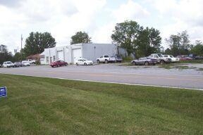
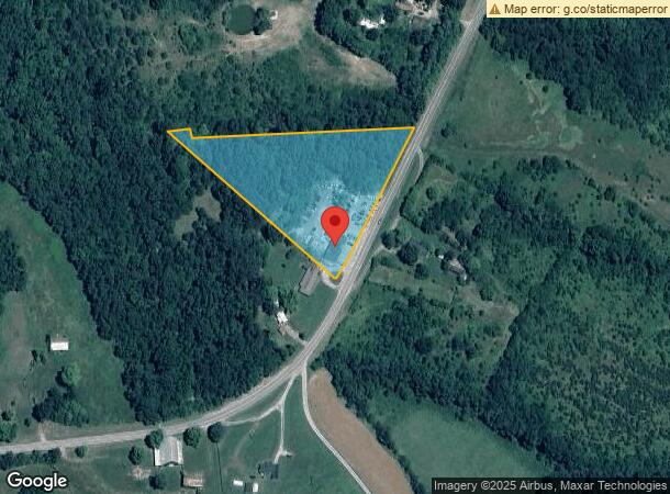
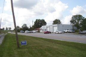
Property Record
3281 Taft Hwy, Dry Ridge, KY 41035
NEARBY LISTINGS FOR SALE OR LEASE
Property Detail
3281 Taft Hwy
035-00-00-001.01
GARAGE & 3.5 AC
Autorepair
Grant
X
Kentucky
21081C0120A
3.50 AC
2024
Grant County
2024
Cincinnati/Dayton
920201
Cincinnati, OH-KY-IN
2,700 SF
DEMOGRAPHICS near 3281 Taft Hwy
1 Mile
3 Mile
5 Mile
2024 Total Population
154
1,156
5,259
2029 Population
164
1,226
5,552
Pop Growth 2024-2029
+ 6.49%
+ 6.06%
+ 5.57%
Average Age
42
42
41
2024 Total Households
56
431
1,954
HH Growth 2024-2029
+ 7.14%
+ 6.03%
+ 5.63%
Median Household Inc
$101,389
$77,678
$59,852
Avg Household Size
2.70
2.60
2.60
2024 Avg HH Vehicles
2.00
2.00
2.00
Median Home Value
$299,999
$270,588
$232,545
Median Year Built
1990
1988
1988
Nearby Places
- Restaurants
- Banks
- Shops
- Fitness
- Groceries
PUBLIC TRANSPORTATION
AIRPORT
Cincinnati/Northern Kentucky International
DRIVE
WALK
Distance
Cincinnati/Northern Kentucky International
42 min
30.3 mi
Freight Ports
Port of Toledo
DRIVE
WALK
Distance
Port of Toledo
284 min
242.4 mi
Nearby Properties
Address
Land Use
TOTAL SIZE
Lot Size
Zoning
Address
Land Use
TOTAL SIZE
Lot Size
Zoning
154,743 SF
16.19 AC
COM
Address
Land Use
TOTAL SIZE
Lot Size
Zoning
Address
Land Use
TOTAL SIZE
Lot Size
Zoning
7.62 AC
Address
Land Use
TOTAL SIZE
Lot Size
Zoning
39,548 SF
1.29 AC
COM
Address
Land Use
TOTAL SIZE
Lot Size
Zoning
10.81 AC
Address
Land Use
TOTAL SIZE
Lot Size
Zoning
21,420 SF
4.83 AC
Address
Land Use
TOTAL SIZE
Lot Size
Zoning
3,350 SF
1 AC
COM
Address
Land Use
TOTAL SIZE
Lot Size
Zoning
Address
Land Use
TOTAL SIZE
Lot Size
Zoning
4,230 SF
0.84 AC
COM
Address
Land Use
TOTAL SIZE
Lot Size
Zoning
35,685 SF
1.32 AC
COM
Address
Land Use
TOTAL SIZE
Lot Size
Zoning
14,142 SF
3 AC
Address
Land Use
TOTAL SIZE
Lot Size
Zoning
5,100 SF
0.85 AC
Address
Land Use
TOTAL SIZE
Lot Size
Zoning
15.35 AC
Address
Land Use
TOTAL SIZE
Lot Size
Zoning
22,152 SF
1.13 AC
COM
Address
Land Use
TOTAL SIZE
Lot Size
Zoning
127,735 SF
11.10 AC
Address
Land Use
TOTAL SIZE
Lot Size
Zoning
Address
Land Use
TOTAL SIZE
Lot Size
Zoning
5,850 SF
0.83 AC
Address
Land Use
TOTAL SIZE
Lot Size
Zoning
5,232 SF
2.50 AC
Address
Land Use
TOTAL SIZE
Lot Size
Zoning
8,540 SF
3.25 AC
COM
Address
Land Use
TOTAL SIZE
Lot Size
Zoning
3,248 SF
0.71 AC
Address
Land Use
TOTAL SIZE
Lot Size
Zoning
11,150 SF
1.07 AC
COM
Address
Land Use
TOTAL SIZE
Lot Size
Zoning
Address
Land Use
TOTAL SIZE
Lot Size
Zoning
17,336 SF
1.40 AC
COM
Address
Land Use
TOTAL SIZE
Lot Size
Zoning
1,932 SF
0.75 AC
COM
Address
Land Use
TOTAL SIZE
Lot Size
Zoning
18,792 SF
9.49 AC
COM
Address
Land Use
TOTAL SIZE
Lot Size
Zoning
9,600 SF
0.88 AC
Address
Land Use
TOTAL SIZE
Lot Size
Zoning
5,076 SF
1.18 AC
COM
Address
Land Use
TOTAL SIZE
Lot Size
Zoning
7,072 SF
2.36 AC
Address
Land Use
TOTAL SIZE
Lot Size
Zoning
2,015 SF
1.13 AC
Address
Land Use
TOTAL SIZE
Lot Size
Zoning
8,600 SF
1.14 AC
COM
The World's #1 Commercial Real Estate Marketplace
Connect with us
© 2025 CoStar Group
The information above has been obtained from sources believed reliable. While we do not doubt its accuracy we have not verified it and make no guarantee, warranty or representation about it. It is your responsibility to independently confirm its accuracy and completeness. Any projections, opinions, assumptions, or estimates used are for example only and do not represent the current or future performance of the property. The value of this transaction to you depends on tax and other factors which should be evaluated by your tax, financial, and legal advisors. You and your advisors should conduct a careful, independent investigation of the property to determine to your satisfaction the suitability of the property for your needs.