Property Record
3295 Route 100, Macungie, PA 18062
NEARBY LISTINGS FOR SALE OR LEASE
Property Detail
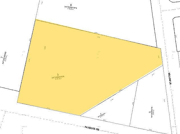
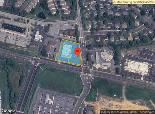
3295 Route 100
547359658705-1
LOTS: 005
Drugstorepharmacycvswalgreens
Lehigh
X
Pennsylvania
42011C0250G
5
2024
1.44 AC
2024
Lehigh Valley
006312
Philadelphia
11,891 SF
Allentown-Bethlehem-Easton, PA-NJ
DEMOGRAPHICS near 3295 Route 100
1 Mile
3 Mile
5 Mile
2024 Total Population
7,727
38,646
90,966
2029 Population
7,778
38,798
91,508
Pop Growth 2024-2029
+ 0.66%
+ 0.39%
+ 0.60%
Average Age
40
42
42
2024 Total Households
3,101
14,875
35,384
HH Growth 2024-2029
+ 0.61%
+ 0.37%
+ 0.57%
Median Household Inc
$81,528
$96,084
$94,202
Avg Household Size
2.50
2.60
2.50
2024 Avg HH Vehicles
2.00
2.00
2.00
Median Home Value
$288,218
$305,482
$299,034
Median Year Built
1993
1989
1984
Nearby Places
- Restaurants
- Banks
- Shops
- Fitness
- Groceries
PUBLIC TRANSPORTATION
AIRPORT
Lehigh Valley International
DRIVE
WALK
Distance
Lehigh Valley International
28 min
18.1 mi
Freight Ports
Port of Philadelphia
DRIVE
WALK
Distance
Port of Philadelphia
87 min
66.4 mi
Nearby Properties
Address
Land Use
TOTAL SIZE
Lot Size
Zoning
Address
Land Use
TOTAL SIZE
Lot Size
Zoning
1,155,164 SF
101.05 AC
L1
Address
Land Use
TOTAL SIZE
Lot Size
Zoning
600,000 SF
72.02 AC
L1
Address
Land Use
TOTAL SIZE
Lot Size
Zoning
1,200,000 SF
77.38 AC
HI-S
Address
Land Use
TOTAL SIZE
Lot Size
Zoning
1,088,000 SF
70.68 AC
HI-S
Address
Land Use
TOTAL SIZE
Lot Size
Zoning
927,980 SF
58.81 AC
HI-S
Address
Land Use
TOTAL SIZE
Lot Size
Zoning
199,343 SF
48.68 AC
O
Address
Land Use
TOTAL SIZE
Lot Size
Zoning
651,393 SF
71.96 AC
HI-S
Address
Land Use
TOTAL SIZE
Lot Size
Zoning
698,350 SF
42.82 AC
O
Address
Land Use
TOTAL SIZE
Lot Size
Zoning
7,132 SF
21.72 AC
C
Address
Land Use
TOTAL SIZE
Lot Size
Zoning
205,985 SF
28.37 AC
C
Address
Land Use
TOTAL SIZE
Lot Size
Zoning
535,000 SF
39.49 AC
O
Address
Land Use
TOTAL SIZE
Lot Size
Zoning
580,000 SF
38.42 AC
I
Address
Land Use
TOTAL SIZE
Lot Size
Zoning
5,762 SF
31.01 AC
U
Address
Land Use
TOTAL SIZE
Lot Size
Zoning
493,200 SF
41.29 AC
O
Address
Land Use
TOTAL SIZE
Lot Size
Zoning
77,506 SF
24.65 AC
C
Address
Land Use
TOTAL SIZE
Lot Size
Zoning
32,500 SF
147.04 AC
I
Address
Land Use
TOTAL SIZE
Lot Size
Zoning
400,000 SF
26.46 AC
I
Address
Land Use
TOTAL SIZE
Lot Size
Zoning
314,704 SF
24.70 AC
O
Address
Land Use
TOTAL SIZE
Lot Size
Zoning
271,080 SF
33.88 AC
HI-S
Address
Land Use
TOTAL SIZE
Lot Size
Zoning
269,592 SF
44.42 AC
LI
Address
Land Use
TOTAL SIZE
Lot Size
Zoning
85,585 SF
24.47 AC
SR
Address
Land Use
TOTAL SIZE
Lot Size
Zoning
84,058 SF
13.18 AC
C
Address
Land Use
TOTAL SIZE
Lot Size
Zoning
73,450 SF
4.93 AC
C
Address
Land Use
TOTAL SIZE
Lot Size
Zoning
61,779 SF
4.49 AC
R-1
Address
Land Use
TOTAL SIZE
Lot Size
Zoning
269,089 SF
19.49 AC
O
Address
Land Use
TOTAL SIZE
Lot Size
Zoning
80,146 SF
4.34 AC
C
Address
Land Use
TOTAL SIZE
Lot Size
Zoning
210,000 SF
20.53 AC
I
Address
Land Use
TOTAL SIZE
Lot Size
Zoning
15,472 SF
10.40 AC
R-7.
Address
Land Use
TOTAL SIZE
Lot Size
Zoning
1,922 SF
44.40 AC
I
Address
Land Use
TOTAL SIZE
Lot Size
Zoning
106,550 SF
20.62 AC
C
The World's #1 Commercial Real Estate Marketplace
Connect with us
© 2025 CoStar Group
The information above has been obtained from sources believed reliable. While we do not doubt its accuracy we have not verified it and make no guarantee, warranty or representation about it. It is your responsibility to independently confirm its accuracy and completeness. Any projections, opinions, assumptions, or estimates used are for example only and do not represent the current or future performance of the property. The value of this transaction to you depends on tax and other factors which should be evaluated by your tax, financial, and legal advisors. You and your advisors should conduct a careful, independent investigation of the property to determine to your satisfaction the suitability of the property for your needs.