Property Record
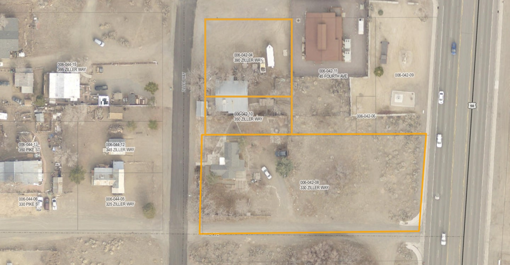
390 Ziller Way, Dayton, NV 89403
NEARBY LISTINGS FOR SALE OR LEASE
Property Detail
390 Ziller Way
Fernley, NV
Town/Dayton
006-042-04
23-16-21 FR SW4 NE4; FR SW4 NE4; LOTS 9 & 10 DAYTON TOWNSHIP ROS #417770 LOTS 9 & 10
Commercialacreage
Lyon
X
Nevada
32019C0452F
9-10
2024
0.25 AC
2024
Lyon County
960305
Reno/Sparks
DEMOGRAPHICS near 390 Ziller Way
1 Mile
3 Mile
5 Mile
2024 Total Population
1,503
8,769
12,450
2029 Population
1,611
9,437
13,349
Pop Growth 2024-2029
+ 7.19%
+ 7.62%
+ 7.22%
Average Age
44
44
44
2024 Total Households
581
3,497
4,936
HH Growth 2024-2029
+ 7.06%
+ 7.64%
+ 7.19%
Median Household Inc
$86,018
$79,760
$78,688
Avg Household Size
2.60
2.50
2.50
2024 Avg HH Vehicles
2.00
2.00
2.00
Median Home Value
$409,906
$373,587
$371,033
Median Year Built
1994
1999
1997
Nearby Places
- Restaurants
- Banks
- Shops
- Fitness
- Groceries
PUBLIC TRANSPORTATION
AIRPORT
Reno/Tahoe International
DRIVE
WALK
Distance
Reno/Tahoe International
65 min
41.1 mi
Freight Ports
Port of Stockton
DRIVE
WALK
Distance
Port of Stockton
234 min
162.9 mi
Nearby Properties
Address
Land Use
TOTAL SIZE
Lot Size
Zoning
Address
Land Use
TOTAL SIZE
Lot Size
Zoning
619,375 SF
42.46 AC
ME
Address
Land Use
TOTAL SIZE
Lot Size
Zoning
32,460 SF
37.48 AC
RR5
Address
Land Use
TOTAL SIZE
Lot Size
Zoning
47,941 SF
10.33 AC
MULT
Address
Land Use
TOTAL SIZE
Lot Size
Zoning
350,286 SF
14.77 AC
ME
Address
Land Use
TOTAL SIZE
Lot Size
Zoning
38,576 SF
80.45 AC
RR5
Address
Land Use
TOTAL SIZE
Lot Size
Zoning
9,804 SF
3.31 AC
MFR
Address
Land Use
TOTAL SIZE
Lot Size
Zoning
184,000 SF
16.63 AC
ME
Address
Land Use
TOTAL SIZE
Lot Size
Zoning
64,532 SF
7 AC
C2
Address
Land Use
TOTAL SIZE
Lot Size
Zoning
15,773 SF
1.80 AC
NR1
Address
Land Use
TOTAL SIZE
Lot Size
Zoning
144,761 SF
11.73 AC
ME
Address
Land Use
TOTAL SIZE
Lot Size
Zoning
3,739 SF
26.66 AC
RR3
Address
Land Use
TOTAL SIZE
Lot Size
Zoning
104,928 SF
10 AC
ME
Address
Land Use
TOTAL SIZE
Lot Size
Zoning
1,579 SF
6.73 AC
C2
Address
Land Use
TOTAL SIZE
Lot Size
Zoning
6,940 SF
1 AC
C1
Address
Land Use
TOTAL SIZE
Lot Size
Zoning
19,934 SF
2.18 AC
C2
Address
Land Use
TOTAL SIZE
Lot Size
Zoning
105,645 SF
6.33 AC
ME
Address
Land Use
TOTAL SIZE
Lot Size
Zoning
20,100 SF
6.58 AC
C1
Address
Land Use
TOTAL SIZE
Lot Size
Zoning
7,380 SF
1.07 AC
MULT
Address
Land Use
TOTAL SIZE
Lot Size
Zoning
21,119 SF
3.10 AC
C2
Address
Land Use
TOTAL SIZE
Lot Size
Zoning
15,264 SF
1.60 AC
C2
Address
Land Use
TOTAL SIZE
Lot Size
Zoning
2,989 SF
3.21 AC
C2
Address
Land Use
TOTAL SIZE
Lot Size
Zoning
5,904 SF
3.40 AC
C2
Address
Land Use
TOTAL SIZE
Lot Size
Zoning
60,610 SF
6 AC
ME
Address
Land Use
TOTAL SIZE
Lot Size
Zoning
9,880 SF
2.31 AC
NR2
Address
Land Use
TOTAL SIZE
Lot Size
Zoning
3,600 SF
56.13 AC
MULT
Address
Land Use
TOTAL SIZE
Lot Size
Zoning
37,992 SF
5.03 AC
ME
Address
Land Use
TOTAL SIZE
Lot Size
Zoning
21,349 SF
1.82 AC
C2
Address
Land Use
TOTAL SIZE
Lot Size
Zoning
672 SF
5.37 AC
C2
Address
Land Use
TOTAL SIZE
Lot Size
Zoning
17.04 AC
C2
Address
Land Use
TOTAL SIZE
Lot Size
Zoning
94.77 AC
ME
The World's #1 Commercial Real Estate Marketplace
Connect with us
© 2025 CoStar Group
The information above has been obtained from sources believed reliable. While we do not doubt its accuracy we have not verified it and make no guarantee, warranty or representation about it. It is your responsibility to independently confirm its accuracy and completeness. Any projections, opinions, assumptions, or estimates used are for example only and do not represent the current or future performance of the property. The value of this transaction to you depends on tax and other factors which should be evaluated by your tax, financial, and legal advisors. You and your advisors should conduct a careful, independent investigation of the property to determine to your satisfaction the suitability of the property for your needs.