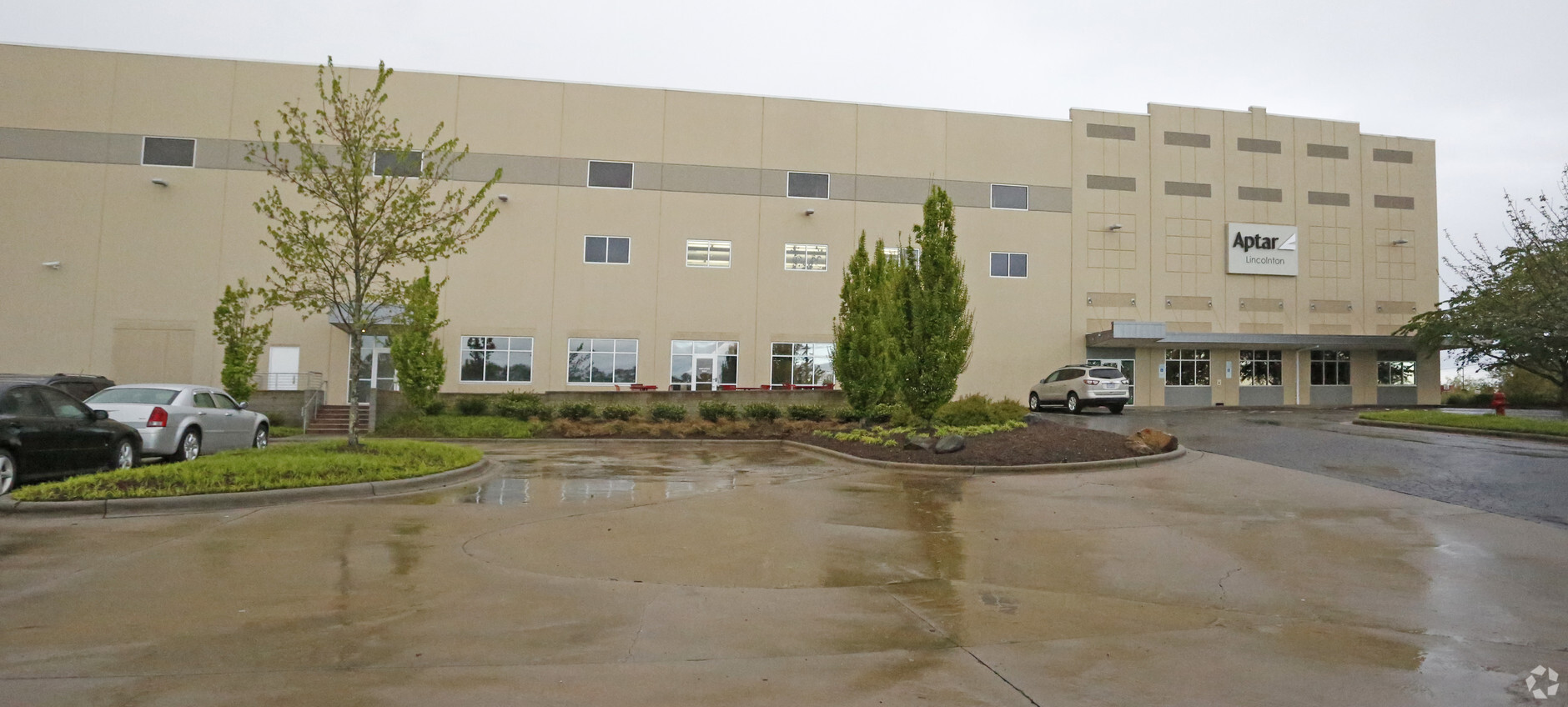
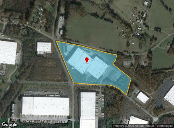
Property Record
3300 Finger Mill Rd, Lincolnton, NC 28092


NEARBY LISTINGS FOR SALE OR LEASE
Property Detail
3300 Finger Mill Rd
Charlotte-Concord-Gastonia, NC-SC
Robb & Stucky Limited Partners
78377
ROBB & STUCKY LTED LAND
Manufacturinglight
Lincoln
2024
North Carolina
2024
23.76 AC
070800
Lincoln County
316,596 SF
Charlotte
DEMOGRAPHICS near 3300 Finger Mill Rd
1 Mile
3 Mile
5 Mile
2024 Total Population
710
11,074
28,777
2029 Population
812
12,334
32,370
Pop Growth 2024-2029
+ 14.37%
+ 11.38%
+ 12.49%
Average Age
40
40
41
2024 Total Households
272
4,354
11,275
HH Growth 2024-2029
+ 14.71%
+ 11.44%
+ 12.75%
Median Household Inc
$48,529
$59,607
$64,537
Avg Household Size
2.60
2.50
2.50
2024 Avg HH Vehicles
2.00
2.00
2.00
Median Home Value
$115,625
$168,415
$191,057
Median Year Built
1992
1988
1987
Nearby Places
- Restaurants
- Banks
- Shops
- Fitness
- Groceries
PUBLIC TRANSPORTATION
AIRPORT
Charlotte/Douglas International
DRIVE
WALK
Distance
Charlotte/Douglas International
54 min
36.7 mi
Freight Ports
North Charleston Terminal
DRIVE
WALK
Distance
North Charleston Terminal
268 min
232.8 mi
Nearby Properties
Address
Land Use
TOTAL SIZE
Lot Size
Zoning
Address
Land Use
TOTAL SIZE
Lot Size
Zoning
999,249 SF
81.97 AC
I-G
Address
Land Use
TOTAL SIZE
Lot Size
Zoning
362,664 SF
48.66 AC
I-G
Address
Land Use
TOTAL SIZE
Lot Size
Zoning
385,000 SF
33.43 AC
I-G
Address
Land Use
TOTAL SIZE
Lot Size
Zoning
415,540 SF
29.21 AC
I-G
Address
Land Use
TOTAL SIZE
Lot Size
Zoning
62.82 AC
R-20
Address
Land Use
TOTAL SIZE
Lot Size
Zoning
279,874 SF
30.14 AC
I-G
Address
Land Use
TOTAL SIZE
Lot Size
Zoning
307,200 SF
35.25 AC
I-G
Address
Land Use
TOTAL SIZE
Lot Size
Zoning
272,580 SF
22.64 AC
I-G
Address
Land Use
TOTAL SIZE
Lot Size
Zoning
220,808 SF
30.48 AC
I-G
Address
Land Use
TOTAL SIZE
Lot Size
Zoning
120,010 SF
73.15 AC
R-20
Address
Land Use
TOTAL SIZE
Lot Size
Zoning
148,421 SF
14.44 AC
I-G
Address
Land Use
TOTAL SIZE
Lot Size
Zoning
105,148 SF
12.53 AC
I-G
Address
Land Use
TOTAL SIZE
Lot Size
Zoning
119,354 SF
20.15 AC
I-G
Address
Land Use
TOTAL SIZE
Lot Size
Zoning
192,292 SF
19.81 AC
M-1
Address
Land Use
TOTAL SIZE
Lot Size
Zoning
20.93 AC
R-15
Address
Land Use
TOTAL SIZE
Lot Size
Zoning
15.67 AC
R-15
Address
Land Use
TOTAL SIZE
Lot Size
Zoning
8,228 SF
10.82 AC
R-T
Address
Land Use
TOTAL SIZE
Lot Size
Zoning
90,009 SF
9.59 AC
I-G
Address
Land Use
TOTAL SIZE
Lot Size
Zoning
76,742 SF
7.12 AC
I-G
Address
Land Use
TOTAL SIZE
Lot Size
Zoning
60,606 SF
8.54 AC
I-G
Address
Land Use
TOTAL SIZE
Lot Size
Zoning
33.07 AC
R-11
Address
Land Use
TOTAL SIZE
Lot Size
Zoning
6,912 SF
30.20 AC
R-25 & R-O
Address
Land Use
TOTAL SIZE
Lot Size
Zoning
45,000 SF
11.38 AC
I-G
Address
Land Use
TOTAL SIZE
Lot Size
Zoning
38,400 SF
5.15 AC
I-G
Address
Land Use
TOTAL SIZE
Lot Size
Zoning
137,440 SF
15.12 AC
M-1
Address
Land Use
TOTAL SIZE
Lot Size
Zoning
156,844 SF
13.87 AC
GMC
Address
Land Use
TOTAL SIZE
Lot Size
Zoning
93,038 SF
7.16 AC
M-1
Address
Land Use
TOTAL SIZE
Lot Size
Zoning
8,608 SF
13.02 AC
M-1
Address
Land Use
TOTAL SIZE
Lot Size
Zoning
139,240 SF
94.37 AC
I-G
The World's #1 Commercial Real Estate Marketplace
Connect with us
© 2025 CoStar Group
The information above has been obtained from sources believed reliable. While we do not doubt its accuracy we have not verified it and make no guarantee, warranty or representation about it. It is your responsibility to independently confirm its accuracy and completeness. Any projections, opinions, assumptions, or estimates used are for example only and do not represent the current or future performance of the property. The value of this transaction to you depends on tax and other factors which should be evaluated by your tax, financial, and legal advisors. You and your advisors should conduct a careful, independent investigation of the property to determine to your satisfaction the suitability of the property for your needs.