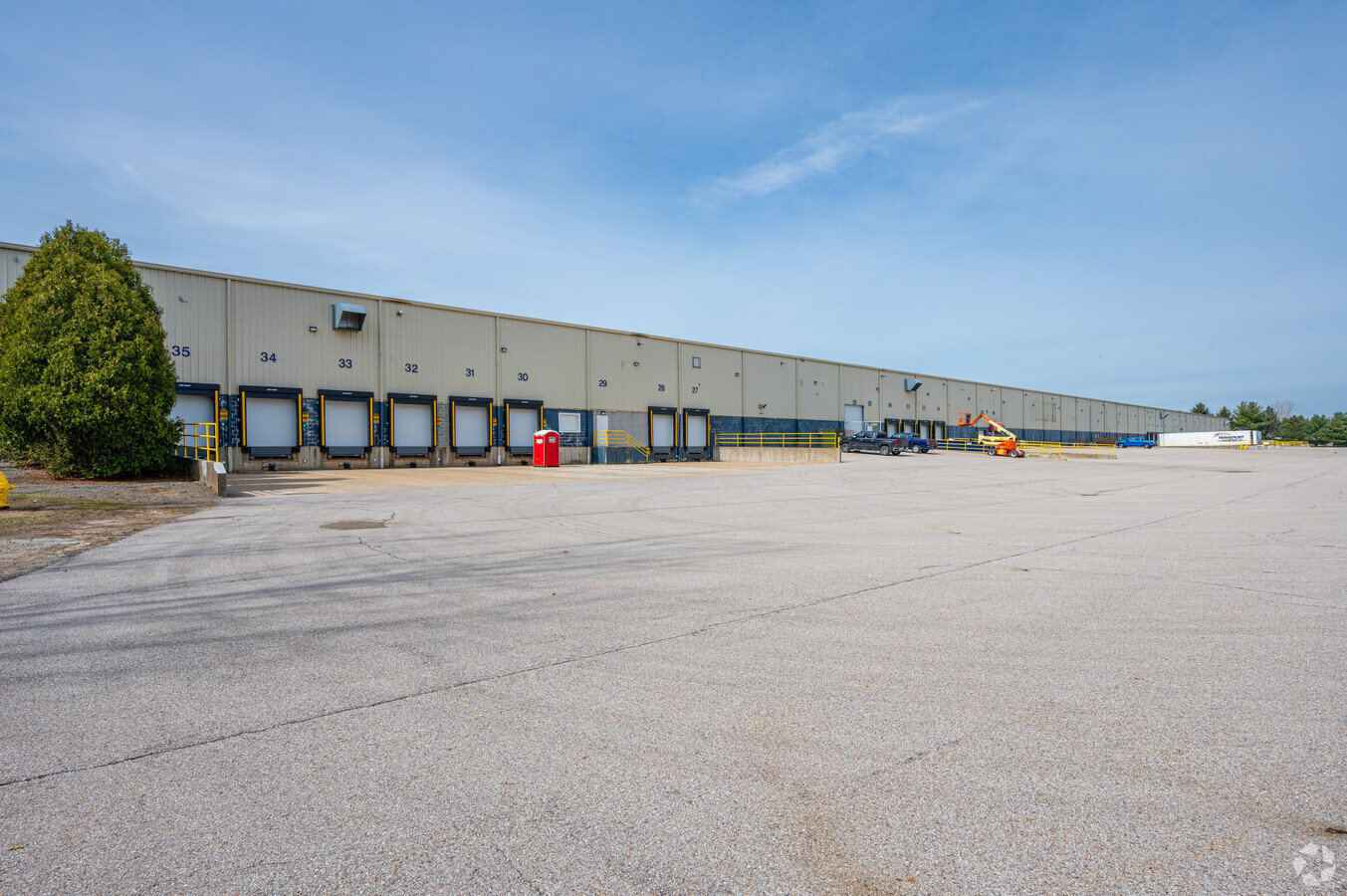
Property Record
3310 William Richardson Dr, South Bend, IN 46628
NEARBY LISTINGS FOR SALE OR LEASE
Property Detail
3310 William Richardson Dr
South Bend-Mishawaka, IN-MI
Toll Road Industrial Park Phase Two
71-03-21-276-003.000-009
TOLL ROAD INDUSTRIAL PARK PHASE TWO SECTION ONE LOT 1 ANNEXED FROM 04-1013-0216 92-93
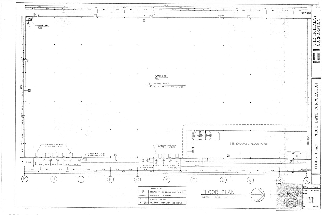
Warehouse
St Joseph
X
Indiana
18141C0181D
1
2022
6.27 AC
2023
Greater South Bend
011001
South Bend/Mishawaka
100,044 SF
DEMOGRAPHICS near 3310 William Richardson Dr
1 Mile
3 Mile
5 Mile
2024 Total Population
3,653
27,798
102,894
2029 Population
3,605
27,715
103,234
Pop Growth 2024-2029
(1.31%)
(0.30%)
+ 0.33%
Average Age
40
39
37
2024 Total Households
1,739
11,335
38,144
HH Growth 2024-2029
(1.32%)
(0.40%)
+ 0.36%
Median Household Inc
$48,515
$54,708
$54,782
Avg Household Size
2.10
2.40
2.40
2024 Avg HH Vehicles
1.00
2.00
2.00
Median Home Value
$181,743
$148,961
$150,473
Median Year Built
1986
1968
1963
Nearby Places
- Restaurants
- Banks
- Shops
- Fitness
- Groceries
PUBLIC TRANSPORTATION
AIRPORT
South Bend Regional
DRIVE
WALK
Distance
South Bend Regional
8 min
3.5 mi
Freight Ports
Port of Baltimore
DRIVE
WALK
Distance
Port of Baltimore
1 min
537.1 mi
SALE & LEASE HISTORY
LISTING DATE
SALE/LEASE

Sep 29, 2022
For Lease
Mar 30, 2017
For Lease
Nearby Properties
Address
Land Use
TOTAL SIZE
Lot Size
Zoning
Address
Land Use
TOTAL SIZE
Lot Size
Zoning
538,554 SF
75.34 AC
Address
Land Use
TOTAL SIZE
Lot Size
Zoning
315,000 SF
25.91 AC
Address
Land Use
TOTAL SIZE
Lot Size
Zoning
136,845 SF
0.84 AC
Address
Land Use
TOTAL SIZE
Lot Size
Zoning
35,884 SF
337.40 AC
Address
Land Use
TOTAL SIZE
Lot Size
Zoning
174,997 SF
0.70 AC
Address
Land Use
TOTAL SIZE
Lot Size
Zoning
356,520 SF
28.07 AC
Address
Land Use
TOTAL SIZE
Lot Size
Zoning
650,526 SF
20.04 AC
Address
Land Use
TOTAL SIZE
Lot Size
Zoning
60,688 SF
21.14 AC
Address
Land Use
TOTAL SIZE
Lot Size
Zoning
747,842 SF
30.05 AC
Address
Land Use
TOTAL SIZE
Lot Size
Zoning
232,200 SF
21.27 AC
Address
Land Use
TOTAL SIZE
Lot Size
Zoning
166,500 SF
13.88 AC
Address
Land Use
TOTAL SIZE
Lot Size
Zoning
228,400 SF
11.81 AC
Address
Land Use
TOTAL SIZE
Lot Size
Zoning
114,844 SF
4.17 AC
Address
Land Use
TOTAL SIZE
Lot Size
Zoning
212,497 SF
31.80 AC
Address
Land Use
TOTAL SIZE
Lot Size
Zoning
225,000 SF
19.59 AC
Address
Land Use
TOTAL SIZE
Lot Size
Zoning
210,420 SF
24.58 AC
Address
Land Use
TOTAL SIZE
Lot Size
Zoning
210,420 SF
30.25 AC
Address
Land Use
TOTAL SIZE
Lot Size
Zoning
104,812 SF
9.45 AC
Address
Land Use
TOTAL SIZE
Lot Size
Zoning
62,874 SF
31.51 AC
Address
Land Use
TOTAL SIZE
Lot Size
Zoning
178,316 SF
9.43 AC
Address
Land Use
TOTAL SIZE
Lot Size
Zoning
79,451 SF
4.90 AC
Address
Land Use
TOTAL SIZE
Lot Size
Zoning
214,657 SF
26.65 AC
Address
Land Use
TOTAL SIZE
Lot Size
Zoning
203,750 SF
22.36 AC
Address
Land Use
TOTAL SIZE
Lot Size
Zoning
260,320 SF
23.71 AC
Address
Land Use
TOTAL SIZE
Lot Size
Zoning
402,880 SF
45.61 AC
Address
Land Use
TOTAL SIZE
Lot Size
Zoning
63,374 SF
0.43 AC
Address
Land Use
TOTAL SIZE
Lot Size
Zoning
204,880 SF
9.55 AC
Address
Land Use
TOTAL SIZE
Lot Size
Zoning
111,618 SF
7.44 AC
Address
Land Use
TOTAL SIZE
Lot Size
Zoning
165,000 SF
15.88 AC
Address
Land Use
TOTAL SIZE
Lot Size
Zoning
70,170 SF
4.01 AC
The World's #1 Commercial Real Estate Marketplace
Connect with us
© 2025 CoStar Group
The information above has been obtained from sources believed reliable. While we do not doubt its accuracy we have not verified it and make no guarantee, warranty or representation about it. It is your responsibility to independently confirm its accuracy and completeness. Any projections, opinions, assumptions, or estimates used are for example only and do not represent the current or future performance of the property. The value of this transaction to you depends on tax and other factors which should be evaluated by your tax, financial, and legal advisors. You and your advisors should conduct a careful, independent investigation of the property to determine to your satisfaction the suitability of the property for your needs.