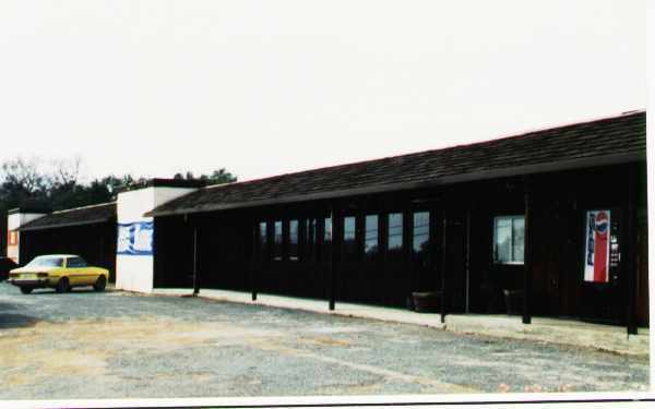
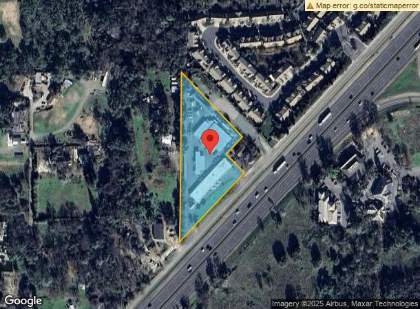
Property Record
3320 Boyington Rd, Loomis, CA 95650
NEARBY LISTINGS FOR SALE OR LEASE
Property Detail
3320 Boyington Rd
043-071-006
2.4 AC POR PAR B PMOR 14 24
Vehiclerentalsvehiclesales
Placer
X
California
06061C0960H
2.40 AC
2023
Auburn/Loomis
2023
Sacramento
021203
Sacramento--Roseville--Arden-Arcade, CA
17,560 SF
DEMOGRAPHICS near 3320 Boyington Rd
1 Mile
3 Mile
5 Mile
2024 Total Population
1,802
16,000
61,608
2029 Population
1,910
17,049
66,315
Pop Growth 2024-2029
+ 5.99%
+ 6.56%
+ 7.64%
Average Age
42
42
44
2024 Total Households
656
5,708
22,790
HH Growth 2024-2029
+ 5.95%
+ 6.66%
+ 7.68%
Median Household Inc
$92,945
$114,717
$118,967
Avg Household Size
2.70
2.80
2.70
2024 Avg HH Vehicles
2.00
2.00
2.00
Median Home Value
$751,639
$758,614
$745,796
Median Year Built
1980
1979
1993
Nearby Places
- Restaurants
- Banks
- Shops
- Fitness
- Groceries
PUBLIC TRANSPORTATION
COMMUTER RAIL
Rocklin Amtrak Station (Capitol Corridor - Amtrak)
DRIVE
WALK
Distance
Rocklin Amtrak Station (Capitol Corridor - Amtrak)
9 min
5.9 mi
Auburn Amtrak (Capitol Corridor - Amtrak)
DRIVE
WALK
Distance
Auburn Amtrak (Capitol Corridor - Amtrak)
13 min
8.9 mi
AIRPORT
Sacramento International
DRIVE
WALK
Distance
Sacramento International
44 min
33.5 mi
Freight Ports
Port of Stockton
DRIVE
WALK
Distance
Port of Stockton
87 min
73.7 mi
Nearby Properties
Address
Land Use
TOTAL SIZE
Lot Size
Zoning
Address
Land Use
TOTAL SIZE
Lot Size
Zoning
246,349 SF
9.89 AC
Address
Land Use
TOTAL SIZE
Lot Size
Zoning
194,087 SF
15.82 AC
Address
Land Use
TOTAL SIZE
Lot Size
Zoning
199,566 SF
6.40 AC
Address
Land Use
TOTAL SIZE
Lot Size
Zoning
159,029 SF
17.62 AC
Address
Land Use
TOTAL SIZE
Lot Size
Zoning
136,101 SF
10 AC
Address
Land Use
TOTAL SIZE
Lot Size
Zoning
1,992 SF
44.99 AC
RAB100
Address
Land Use
TOTAL SIZE
Lot Size
Zoning
100,348 SF
12.50 AC
Address
Land Use
TOTAL SIZE
Lot Size
Zoning
89,928 SF
6 AC
CG
Address
Land Use
TOTAL SIZE
Lot Size
Zoning
63,608 SF
5.20 AC
CG
Address
Land Use
TOTAL SIZE
Lot Size
Zoning
19,604 SF
3.08 AC
Address
Land Use
TOTAL SIZE
Lot Size
Zoning
25,368 SF
1.08 AC
RH
Address
Land Use
TOTAL SIZE
Lot Size
Zoning
2,169 SF
25.40 AC
Address
Land Use
TOTAL SIZE
Lot Size
Zoning
35,146 SF
4 AC
Address
Land Use
TOTAL SIZE
Lot Size
Zoning
26,750 SF
5.20 AC
CG
Address
Land Use
TOTAL SIZE
Lot Size
Zoning
85,435 SF
2.75 AC
Address
Land Use
TOTAL SIZE
Lot Size
Zoning
26,884 SF
1.40 AC
Address
Land Use
TOTAL SIZE
Lot Size
Zoning
32,362 SF
2.10 AC
Address
Land Use
TOTAL SIZE
Lot Size
Zoning
21,000 SF
2.27 AC
Address
Land Use
TOTAL SIZE
Lot Size
Zoning
12,968 SF
1.19 AC
Address
Land Use
TOTAL SIZE
Lot Size
Zoning
21,000 SF
1.85 AC
Address
Land Use
TOTAL SIZE
Lot Size
Zoning
34,066 SF
2.90 AC
Address
Land Use
TOTAL SIZE
Lot Size
Zoning
12,259 SF
2.60 AC
RE
Address
Land Use
TOTAL SIZE
Lot Size
Zoning
3,135 SF
0.94 AC
Address
Land Use
TOTAL SIZE
Lot Size
Zoning
30,209 SF
5.30 AC
C1UPDC
Address
Land Use
TOTAL SIZE
Lot Size
Zoning
4,177 SF
1.30 AC
Address
Land Use
TOTAL SIZE
Lot Size
Zoning
70,000 SF
3.20 AC
Address
Land Use
TOTAL SIZE
Lot Size
Zoning
20,800 SF
2.10 AC
Address
Land Use
TOTAL SIZE
Lot Size
Zoning
14,834 SF
1.20 AC
Address
Land Use
TOTAL SIZE
Lot Size
Zoning
25,000 SF
2.40 AC
Address
Land Use
TOTAL SIZE
Lot Size
Zoning
61,024 SF
3 AC
IL
The World's #1 Commercial Real Estate Marketplace
Connect with us
© 2025 CoStar Group
The information above has been obtained from sources believed reliable. While we do not doubt its accuracy we have not verified it and make no guarantee, warranty or representation about it. It is your responsibility to independently confirm its accuracy and completeness. Any projections, opinions, assumptions, or estimates used are for example only and do not represent the current or future performance of the property. The value of this transaction to you depends on tax and other factors which should be evaluated by your tax, financial, and legal advisors. You and your advisors should conduct a careful, independent investigation of the property to determine to your satisfaction the suitability of the property for your needs.