Property Record
3320/3322 Skyline Blvd, Cape Coral, FL 33914

NEARBY LISTINGS FOR SALE OR LEASE
Property Detail
3320/3322 Skyline Blvd
Cape Coral-Fort Myers, FL
Cape Coral
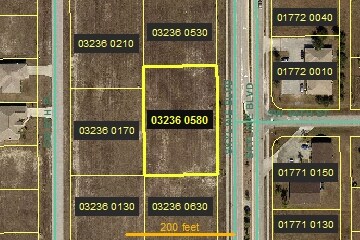
03-45-23-C2-03236.0530
CAPE CORAL UNIT 66 BLK 3236 PB 22 PG 14 LOTS 53 THRU 62 + VAC ALLEY OR 2833 PG 2238
Multifamilydwelling
Lee
X
Florida
12071C0403G
53-62
2024
1.24 AC
2025
Cape Coral
010418
Southwest Florida
DEMOGRAPHICS near 3320/3322 Skyline Blvd
1 Mile
3 Mile
5 Mile
2024 Total Population
10,537
87,328
147,318
2029 Population
12,453
103,699
175,182
Pop Growth 2024-2029
+ 18.18%
+ 18.75%
+ 18.91%
Average Age
41
45
46
2024 Total Households
3,999
35,675
60,581
HH Growth 2024-2029
+ 17.73%
+ 18.33%
+ 18.50%
Median Household Inc
$67,047
$67,433
$66,929
Avg Household Size
2.60
2.40
2.40
2024 Avg HH Vehicles
2.00
2.00
2.00
Median Home Value
$276,211
$296,762
$305,943
Median Year Built
1995
1994
1994
Nearby Places
Map Layers
Map Styles
 Street
 Aerial
- Restaurants
- Banks
- Shops
- Fitness
- Groceries
PUBLIC TRANSPORTATION
AIRPORT
Southwest Florida International
DRIVE
WALK
Distance
Southwest Florida International
36 min
18.2 mi
Punta Gorda
DRIVE
WALK
Distance
Punta Gorda
45 min
27.7 mi
Nearby Properties
Address
Land Use
TOTAL SIZE
Lot Size
Zoning
Address
Land Use
TOTAL SIZE
Lot Size
Zoning
441,999 SF
19.96 AC
R-3
Address
Land Use
TOTAL SIZE
Lot Size
Zoning
476,419 SF
36.49 AC
C1
Address
Land Use
TOTAL SIZE
Lot Size
Zoning
263,280 SF
19.99 AC
RML
Address
Land Use
TOTAL SIZE
Lot Size
Zoning
340,032 SF
30.58 AC
R1-A
Address
Land Use
TOTAL SIZE
Lot Size
Zoning
300,366 SF
10.61 AC
RPUD
Address
Land Use
TOTAL SIZE
Lot Size
Zoning
96,539 SF
74.71 AC
INST
Address
Land Use
TOTAL SIZE
Lot Size
Zoning
212,112 SF
33.92 AC
RD-D
Address
Land Use
TOTAL SIZE
Lot Size
Zoning
4.89 AC
C-1
Address
Land Use
TOTAL SIZE
Lot Size
Zoning
282,066 SF
39.45 AC
INS
Address
Land Use
TOTAL SIZE
Lot Size
Zoning
239,211 SF
56.31 AC
INST
Address
Land Use
TOTAL SIZE
Lot Size
Zoning
158,176 SF
20 AC
R-1
Address
Land Use
TOTAL SIZE
Lot Size
Zoning
144,607 SF
20 AC
INS
Address
Land Use
TOTAL SIZE
Lot Size
Zoning
6.09 AC
MR
Address
Land Use
TOTAL SIZE
Lot Size
Zoning
149,829 SF
5.70 AC
R-3
Address
Land Use
TOTAL SIZE
Lot Size
Zoning
135,838 SF
40 AC
R-1
Address
Land Use
TOTAL SIZE
Lot Size
Zoning
153,651 SF
17.17 AC
R1-B
Address
Land Use
TOTAL SIZE
Lot Size
Zoning
123,133 SF
8.26 AC
C
Address
Land Use
TOTAL SIZE
Lot Size
Zoning
147,599 SF
5.72 AC
RML
Address
Land Use
TOTAL SIZE
Lot Size
Zoning
28,560 SF
5.08 AC
P1-W
Address
Land Use
TOTAL SIZE
Lot Size
Zoning
113,239 SF
12.62 AC
R1-D
Address
Land Use
TOTAL SIZE
Lot Size
Zoning
79,839 SF
8.25 AC
C1-D
Address
Land Use
TOTAL SIZE
Lot Size
Zoning
93,636 SF
4.46 AC
C-1
Address
Land Use
TOTAL SIZE
Lot Size
Zoning
47,423 SF
13.86 AC
R1-D
Address
Land Use
TOTAL SIZE
Lot Size
Zoning
102,906 SF
2.95 AC
C
Address
Land Use
TOTAL SIZE
Lot Size
Zoning
69,261 SF
8.44 AC
WSHP
Address
Land Use
TOTAL SIZE
Lot Size
Zoning
84,145 SF
8.11 AC
C-1
Address
Land Use
TOTAL SIZE
Lot Size
Zoning
58,318 SF
4.99 AC
C
Address
Land Use
TOTAL SIZE
Lot Size
Zoning
103,490 SF
3.47 AC
C1-D
Address
Land Use
TOTAL SIZE
Lot Size
Zoning
100,325 SF
4.86 AC
C-1
Address
Land Use
TOTAL SIZE
Lot Size
Zoning
36,649 SF
2.82 AC
C-1
The World's #1 Commercial Real Estate Marketplace
Connect with us
© 2026 CoStar Group
The information above has been obtained from sources believed reliable. While we do not doubt its accuracy we have not verified it and make no guarantee, warranty or representation about it. It is your responsibility to independently confirm its accuracy and completeness. Any projections, opinions, assumptions, or estimates used are for example only and do not represent the current or future performance of the property. The value of this transaction to you depends on tax and other factors which should be evaluated by your tax, financial, and legal advisors. You and your advisors should conduct a careful, independent investigation of the property to determine to your satisfaction the suitability of the property for your needs.