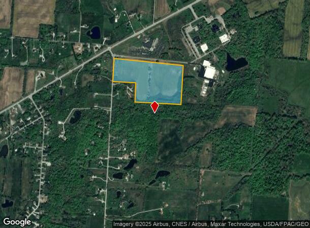
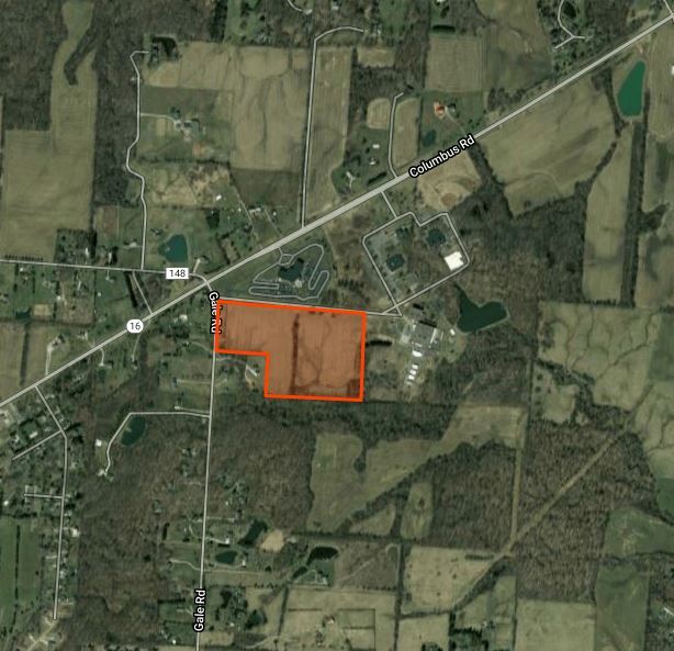
Property Record
3321 Gale Rd, Granville, OH 43023


NEARBY LISTINGS FOR SALE OR LEASE
-
-
View all Granville listings for sale on LoopNet.com
Property Detail
3321 Gale Rd
Columbus, OH
North Part
071-326658-01.004
30.300 AC LOT 1 & UNDIVIDED R13 T1 Q2
Industrialacreage
Licking
X
Ohio
39089C0312J
1
2023
30.30 AC
2023
Licking County
759102
Columbus
DEMOGRAPHICS near 3321 Gale Rd
1 Mile
3 Mile
5 Mile
2024 Total Population
558
7,497
25,333
2029 Population
585
7,862
26,467
Pop Growth 2024-2029
+ 4.84%
+ 4.87%
+ 4.48%
Average Age
41
40
40
2024 Total Households
194
2,545
8,574
HH Growth 2024-2029
+ 4.64%
+ 4.95%
+ 4.67%
Median Household Inc
$122,058
$122,087
$113,372
Avg Household Size
2.80
2.80
2.70
2024 Avg HH Vehicles
3.00
2.00
2.00
Median Home Value
$322,340
$337,569
$316,429
Median Year Built
1990
1984
1987
Nearby Places
- Restaurants
- Banks
- Shops
- Fitness
- Groceries
PUBLIC TRANSPORTATION
AIRPORT
John Glenn Columbus International
DRIVE
WALK
Distance
John Glenn Columbus International
32 min
20.6 mi
Rickenbacker International
DRIVE
WALK
Distance
Rickenbacker International
41 min
29.9 mi
Freight Ports
Port of Toledo
DRIVE
WALK
Distance
Port of Toledo
193 min
155.3 mi
SALE & LEASE HISTORY
LISTING DATE
SALE/LEASE

Jan 08, 2018
For Sale
Nearby Properties
Address
Land Use
TOTAL SIZE
Lot Size
Zoning
Address
Land Use
TOTAL SIZE
Lot Size
Zoning
19,808 SF
60.50 AC
Address
Land Use
TOTAL SIZE
Lot Size
Zoning
92,329 SF
12.86 AC
Address
Land Use
TOTAL SIZE
Lot Size
Zoning
205.82 AC
Address
Land Use
TOTAL SIZE
Lot Size
Zoning
61,166 SF
10.46 AC
Address
Land Use
TOTAL SIZE
Lot Size
Zoning
270 SF
27.60 AC
Address
Land Use
TOTAL SIZE
Lot Size
Zoning
30.69 AC
Address
Land Use
TOTAL SIZE
Lot Size
Zoning
8,376 SF
8.22 AC
Address
Land Use
TOTAL SIZE
Lot Size
Zoning
4,436 SF
58.08 AC
Address
Land Use
TOTAL SIZE
Lot Size
Zoning
34.67 AC
Address
Land Use
TOTAL SIZE
Lot Size
Zoning
11,950 SF
18.09 AC
Address
Land Use
TOTAL SIZE
Lot Size
Zoning
16,160 SF
21.40 AC
Address
Land Use
TOTAL SIZE
Lot Size
Zoning
1,366 SF
86.48 AC
Address
Land Use
TOTAL SIZE
Lot Size
Zoning
1,876 SF
4.97 AC
Address
Land Use
TOTAL SIZE
Lot Size
Zoning
4,350 SF
149.93 AC
Address
Land Use
TOTAL SIZE
Lot Size
Zoning
1,344 SF
151.86 AC
Address
Land Use
TOTAL SIZE
Lot Size
Zoning
96.02 AC
Address
Land Use
TOTAL SIZE
Lot Size
Zoning
1,976 SF
109.62 AC
Address
Land Use
TOTAL SIZE
Lot Size
Zoning
1,866 SF
133 AC
Address
Land Use
TOTAL SIZE
Lot Size
Zoning
1,216 SF
111.45 AC
Address
Land Use
TOTAL SIZE
Lot Size
Zoning
137.31 AC
Address
Land Use
TOTAL SIZE
Lot Size
Zoning
80.83 AC
Address
Land Use
TOTAL SIZE
Lot Size
Zoning
1,790 SF
75.42 AC
Address
Land Use
TOTAL SIZE
Lot Size
Zoning
2,264 SF
129.32 AC
Address
Land Use
TOTAL SIZE
Lot Size
Zoning
78.79 AC
Address
Land Use
TOTAL SIZE
Lot Size
Zoning
14,400 SF
54.94 AC
Address
Land Use
TOTAL SIZE
Lot Size
Zoning
7,680 SF
1.61 AC
Address
Land Use
TOTAL SIZE
Lot Size
Zoning
18,315 SF
82.31 AC
Address
Land Use
TOTAL SIZE
Lot Size
Zoning
6,192 SF
81.45 AC
Address
Land Use
TOTAL SIZE
Lot Size
Zoning
66.41 AC
The World's #1 Commercial Real Estate Marketplace
Connect with us
© 2025 CoStar Group
The information above has been obtained from sources believed reliable. While we do not doubt its accuracy we have not verified it and make no guarantee, warranty or representation about it. It is your responsibility to independently confirm its accuracy and completeness. Any projections, opinions, assumptions, or estimates used are for example only and do not represent the current or future performance of the property. The value of this transaction to you depends on tax and other factors which should be evaluated by your tax, financial, and legal advisors. You and your advisors should conduct a careful, independent investigation of the property to determine to your satisfaction the suitability of the property for your needs.