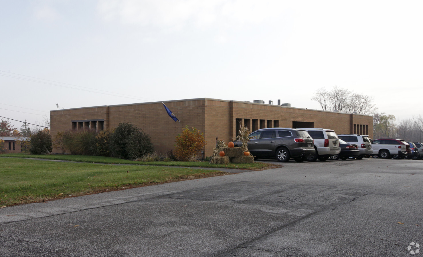
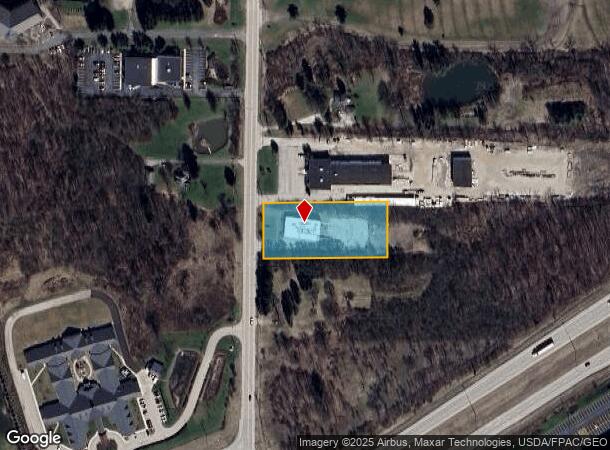
Property Record
3333 Brecksville Rd, Richfield, OH 44286
Current Lease Availabilities
NEARBY LISTINGS FOR SALE OR LEASE
Property Detail
3333 Brecksville Rd
Akron, OH
TR 3 LOT 1 E OF CLEVE MASS RD 1.310A AUD#10842
50-00049
Summit
Officebuilding
Ohio
2023
1
2024
1.16 AC
532502
Akron
9,180 SF
Cleveland
DEMOGRAPHICS near 3333 Brecksville Rd
1 Mile
3 Mile
5 Mile
2024 Total Population
776
6,934
21,467
2029 Population
765
6,815
21,063
Pop Growth 2024-2029
(1.42%)
(1.72%)
(1.88%)
Average Age
46
46
44
2024 Total Households
307
2,624
8,132
HH Growth 2024-2029
(1.30%)
(1.75%)
(2.02%)
Median Household Inc
$112,053
$128,328
$130,070
Avg Household Size
2.50
2.60
2.60
2024 Avg HH Vehicles
2.00
2.00
2.00
Median Home Value
$377,940
$422,933
$386,210
Median Year Built
1969
1976
1982
Nearby Places
- Restaurants
- Banks
- Shops
- Fitness
- Groceries
PUBLIC TRANSPORTATION
COMMUTER RAIL
Indigo Lake (National Park Scenic Railway - Cuyahoga Valley Scenic Railroad)
DRIVE
WALK
Distance
Indigo Lake (National Park Scenic Railway - Cuyahoga Valley Scenic Railroad)
11 min
5.3 mi
Boston Mill (National Park Scenic Railway - Cuyahoga Valley Scenic Railroad)
DRIVE
WALK
Distance
Boston Mill (National Park Scenic Railway - Cuyahoga Valley Scenic Railroad)
12 min
6.9 mi
AIRPORT
Cleveland-Hopkins International
DRIVE
WALK
Distance
Cleveland-Hopkins International
36 min
24.4 mi
Akron-Canton Regional
DRIVE
WALK
Distance
Akron-Canton Regional
39 min
30.2 mi
Freight Ports
Port of Toledo
DRIVE
WALK
Distance
Port of Toledo
140 min
118.8 mi
Nearby Properties
Address
Land Use
TOTAL SIZE
Lot Size
Zoning
Address
Land Use
TOTAL SIZE
Lot Size
Zoning
254,133 SF
38.60 AC
Address
Land Use
TOTAL SIZE
Lot Size
Zoning
Address
Land Use
TOTAL SIZE
Lot Size
Zoning
216,612 SF
16.89 AC
Address
Land Use
TOTAL SIZE
Lot Size
Zoning
72,796 SF
11.49 AC
Address
Land Use
TOTAL SIZE
Lot Size
Zoning
Address
Land Use
TOTAL SIZE
Lot Size
Zoning
87,704 SF
10.02 AC
Address
Land Use
TOTAL SIZE
Lot Size
Zoning
49,530 SF
8.28 AC
Address
Land Use
TOTAL SIZE
Lot Size
Zoning
54,750 SF
8.88 AC
Address
Land Use
TOTAL SIZE
Lot Size
Zoning
111,679 SF
30.05 AC
Address
Land Use
TOTAL SIZE
Lot Size
Zoning
99,468 SF
10.04 AC
Address
Land Use
TOTAL SIZE
Lot Size
Zoning
Address
Land Use
TOTAL SIZE
Lot Size
Zoning
48,928 SF
5.33 AC
Address
Land Use
TOTAL SIZE
Lot Size
Zoning
Address
Land Use
TOTAL SIZE
Lot Size
Zoning
Address
Land Use
TOTAL SIZE
Lot Size
Zoning
Address
Land Use
TOTAL SIZE
Lot Size
Zoning
58,977 SF
2.19 AC
Address
Land Use
TOTAL SIZE
Lot Size
Zoning
Address
Land Use
TOTAL SIZE
Lot Size
Zoning
105,120 SF
8.34 AC
Address
Land Use
TOTAL SIZE
Lot Size
Zoning
42,306 SF
2.82 AC
Address
Land Use
TOTAL SIZE
Lot Size
Zoning
55,070 SF
7 AC
Address
Land Use
TOTAL SIZE
Lot Size
Zoning
Address
Land Use
TOTAL SIZE
Lot Size
Zoning
Address
Land Use
TOTAL SIZE
Lot Size
Zoning
2,016 SF
156 AC
Address
Land Use
TOTAL SIZE
Lot Size
Zoning
59,852 SF
7 AC
Address
Land Use
TOTAL SIZE
Lot Size
Zoning
28,087 SF
184.46 AC
Address
Land Use
TOTAL SIZE
Lot Size
Zoning
81,134 SF
61.23 AC
Address
Land Use
TOTAL SIZE
Lot Size
Zoning
45,231 SF
11.92 AC
Address
Land Use
TOTAL SIZE
Lot Size
Zoning
Address
Land Use
TOTAL SIZE
Lot Size
Zoning
24,919 SF
26.34 AC
Address
Land Use
TOTAL SIZE
Lot Size
Zoning
100,659 SF
8.63 AC
The World's #1 Commercial Real Estate Marketplace
Connect with us
© 2025 CoStar Group
The information above has been obtained from sources believed reliable. While we do not doubt its accuracy we have not verified it and make no guarantee, warranty or representation about it. It is your responsibility to independently confirm its accuracy and completeness. Any projections, opinions, assumptions, or estimates used are for example only and do not represent the current or future performance of the property. The value of this transaction to you depends on tax and other factors which should be evaluated by your tax, financial, and legal advisors. You and your advisors should conduct a careful, independent investigation of the property to determine to your satisfaction the suitability of the property for your needs.