Property Record
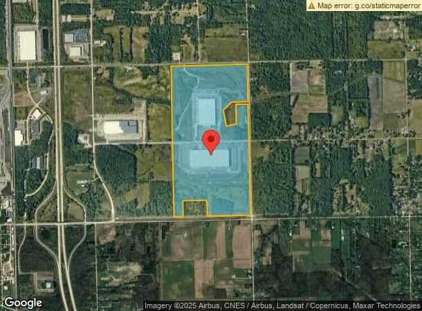
33701 Prescott St, Romulus, MI 48174
NEARBY LISTINGS FOR SALE OR LEASE
Property Detail
33701 Prescott St
75-013-99-0001-711
*04K2B*PT OF NW 1/4 SEC 4 T4S R9E DESC AS BEG S 87D 08M 00S E 977.23 FT FROM W 1/4 COR SEC 4--TH N 02D 42M 00S E 1314.25
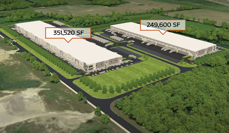
Industrialgeneral
Wayne
X
Michigan
26163C0370F
72.97 AC
2024
Airport District
2024
Detroit
590500
Detroit-Warren-Dearborn, MI
DEMOGRAPHICS near 33701 Prescott St
1 Mile
3 Mile
5 Mile
2024 Total Population
90
10,469
43,891
2029 Population
86
10,041
42,156
Pop Growth 2024-2029
(4.44%)
(4.09%)
(3.95%)
Average Age
44
40
40
2024 Total Households
34
3,950
16,862
HH Growth 2024-2029
(2.94%)
(4.10%)
(3.96%)
Median Household Inc
$120,833
$79,018
$67,125
Avg Household Size
2.60
2.60
2.50
2024 Avg HH Vehicles
3.00
2.00
2.00
Median Home Value
$282,142
$189,264
$213,938
Median Year Built
1964
1973
1975
Nearby Places
- Restaurants
- Banks
- Shops
- Fitness
- Groceries
PUBLIC TRANSPORTATION
AIRPORT
Detroit Metro Wayne County
DRIVE
WALK
Distance
Detroit Metro Wayne County
8 min
4.4 mi
Windsor International
DRIVE
WALK
Distance
Windsor International
53 min
31.8 mi
Freight Ports
Port of Toledo
DRIVE
WALK
Distance
Port of Toledo
58 min
45.0 mi
SALE & LEASE HISTORY
LISTING DATE
SALE/LEASE

Jun 15, 2020
For Lease
Nearby Properties
Address
Land Use
TOTAL SIZE
Lot Size
Zoning
Address
Land Use
TOTAL SIZE
Lot Size
Zoning
516,762 SF
51.63 AC
Address
Land Use
TOTAL SIZE
Lot Size
Zoning
Address
Land Use
TOTAL SIZE
Lot Size
Zoning
500,240 SF
55.95 AC
M2-GEN
Address
Land Use
TOTAL SIZE
Lot Size
Zoning
600,000 SF
M1-LIG
Address
Land Use
TOTAL SIZE
Lot Size
Zoning
323,057 SF
Address
Land Use
TOTAL SIZE
Lot Size
Zoning
500,240 SF
M1-LIG
Address
Land Use
TOTAL SIZE
Lot Size
Zoning
199,722 SF
30.86 AC
M2-GEN
Address
Land Use
TOTAL SIZE
Lot Size
Zoning
462,840 SF
45.66 AC
Address
Land Use
TOTAL SIZE
Lot Size
Zoning
163,792 SF
22.86 AC
RM-MLTI
Address
Land Use
TOTAL SIZE
Lot Size
Zoning
87,000 SF
18.02 AC
Address
Land Use
TOTAL SIZE
Lot Size
Zoning
284,662 SF
17.27 AC
I3 PLAN
Address
Land Use
TOTAL SIZE
Lot Size
Zoning
Address
Land Use
TOTAL SIZE
Lot Size
Zoning
45.66 AC
Address
Land Use
TOTAL SIZE
Lot Size
Zoning
576,545 SF
30.90 AC
I3 PLAN
Address
Land Use
TOTAL SIZE
Lot Size
Zoning
105,000 SF
15.26 AC
Address
Land Use
TOTAL SIZE
Lot Size
Zoning
17.20 AC
B1 LOCA
Address
Land Use
TOTAL SIZE
Lot Size
Zoning
117,695 SF
21.72 AC
M2-GEN
Address
Land Use
TOTAL SIZE
Lot Size
Zoning
89,391 SF
M2-GEN
Address
Land Use
TOTAL SIZE
Lot Size
Zoning
47.09 AC
I2 HEAV
Address
Land Use
TOTAL SIZE
Lot Size
Zoning
15.26 AC
Address
Land Use
TOTAL SIZE
Lot Size
Zoning
M1-LIG
Address
Land Use
TOTAL SIZE
Lot Size
Zoning
Address
Land Use
TOTAL SIZE
Lot Size
Zoning
97,040 SF
10.02 AC
I3 PLAN
Address
Land Use
TOTAL SIZE
Lot Size
Zoning
105,728 SF
18.41 AC
M2-GEN
Address
Land Use
TOTAL SIZE
Lot Size
Zoning
47,806 SF
19.70 AC
I2 HEAV
Address
Land Use
TOTAL SIZE
Lot Size
Zoning
106,704 SF
16.89 AC
M2-GEN
Address
Land Use
TOTAL SIZE
Lot Size
Zoning
88,740 SF
13.36 AC
M2-GEN
Address
Land Use
TOTAL SIZE
Lot Size
Zoning
82,615 SF
8.61 AC
M2-GEN
Address
Land Use
TOTAL SIZE
Lot Size
Zoning
76.32 AC
The World's #1 Commercial Real Estate Marketplace
Connect with us
© 2025 CoStar Group
The information above has been obtained from sources believed reliable. While we do not doubt its accuracy we have not verified it and make no guarantee, warranty or representation about it. It is your responsibility to independently confirm its accuracy and completeness. Any projections, opinions, assumptions, or estimates used are for example only and do not represent the current or future performance of the property. The value of this transaction to you depends on tax and other factors which should be evaluated by your tax, financial, and legal advisors. You and your advisors should conduct a careful, independent investigation of the property to determine to your satisfaction the suitability of the property for your needs.