Property Record
3390 W Linco Rd, Stevensville, MI 49127
NEARBY LISTINGS FOR SALE OR LEASE
-
-
View all Stevensville listings for sale on LoopNet.com
Property Detail
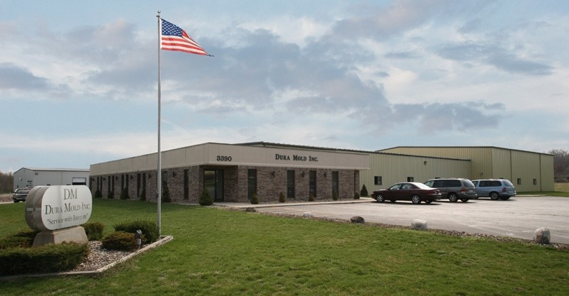
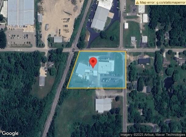
3390 W Linco Rd
11-11-0005-0022-01-7
COM AT NE COR FRL SEC 5 T6S R19W TH S 348'TH W 558.41'TO ELY LN OF RR TH NELY ON SD LN TO N LN SEC 5 TH E TO POB
Manufacturinglight
Berrien
X
Michigan
26021C0210D
4.10 AC
2024
Michigan Southwest Area
2024
Other Market Areas
011101
Niles-Benton Harbor, MI
36,136 SF
DEMOGRAPHICS near 3390 W Linco Rd
1 Mile
3 Mile
5 Mile
2024 Total Population
382
7,659
20,839
2029 Population
379
7,562
20,447
Pop Growth 2024-2029
(0.79%)
(1.27%)
(1.88%)
Average Age
44
43
43
2024 Total Households
165
3,142
8,662
HH Growth 2024-2029
(0.61%)
(1.34%)
(1.96%)
Median Household Inc
$92,934
$92,586
$85,908
Avg Household Size
2.30
2.40
2.30
2024 Avg HH Vehicles
2.00
2.00
2.00
Median Home Value
$289,999
$272,416
$260,605
Median Year Built
1978
1976
1975
Nearby Places
- Restaurants
- Banks
- Shops
- Fitness
- Groceries
PUBLIC TRANSPORTATION
AIRPORT
South Bend International
DRIVE
WALK
Distance
South Bend International
56 min
31.8 mi
Freight Ports
Port Milwaukee
DRIVE
WALK
Distance
Port Milwaukee
211 min
172.3 mi
Nearby Properties
Address
Land Use
TOTAL SIZE
Lot Size
Zoning
Address
Land Use
TOTAL SIZE
Lot Size
Zoning
555.28 AC
I
Address
Land Use
TOTAL SIZE
Lot Size
Zoning
89.27 AC
LD
Address
Land Use
TOTAL SIZE
Lot Size
Zoning
28.55 AC
AG
Address
Land Use
TOTAL SIZE
Lot Size
Zoning
195,253 SF
25.72 AC
HC
Address
Land Use
TOTAL SIZE
Lot Size
Zoning
21,824 SF
21.15 AC
CR
Address
Land Use
TOTAL SIZE
Lot Size
Zoning
65,934 SF
12.33 AC
R-1
Address
Land Use
TOTAL SIZE
Lot Size
Zoning
307.20 AC
AG
Address
Land Use
TOTAL SIZE
Lot Size
Zoning
20,827 SF
2.72 AC
I
Address
Land Use
TOTAL SIZE
Lot Size
Zoning
19,110 SF
2.97 AC
CMU
Address
Land Use
TOTAL SIZE
Lot Size
Zoning
33,460 SF
4 AC
C-1
Address
Land Use
TOTAL SIZE
Lot Size
Zoning
48,972 SF
5.36 AC
C-1
Address
Land Use
TOTAL SIZE
Lot Size
Zoning
7.48 AC
R-1
Address
Land Use
TOTAL SIZE
Lot Size
Zoning
486.73 AC
AG
Address
Land Use
TOTAL SIZE
Lot Size
Zoning
59,000 SF
4.21 AC
LI
Address
Land Use
TOTAL SIZE
Lot Size
Zoning
1.99 AC
HC
Address
Land Use
TOTAL SIZE
Lot Size
Zoning
10 AC
AG
Address
Land Use
TOTAL SIZE
Lot Size
Zoning
35,868 SF
2.15 AC
HC
Address
Land Use
TOTAL SIZE
Lot Size
Zoning
25,000 SF
LD
Address
Land Use
TOTAL SIZE
Lot Size
Zoning
14,737 SF
2.06 AC
CMU
Address
Land Use
TOTAL SIZE
Lot Size
Zoning
40,500 SF
6 AC
LI
Address
Land Use
TOTAL SIZE
Lot Size
Zoning
16,000 SF
2.10 AC
COM &
Address
Land Use
TOTAL SIZE
Lot Size
Zoning
4,248 SF
18.42 AC
VIL-R-4 MH
Address
Land Use
TOTAL SIZE
Lot Size
Zoning
18,966 SF
3.09 AC
CMU
Address
Land Use
TOTAL SIZE
Lot Size
Zoning
12 AC
LD
Address
Land Use
TOTAL SIZE
Lot Size
Zoning
44,884 SF
4.30 AC
LI
Address
Land Use
TOTAL SIZE
Lot Size
Zoning
52,320 SF
7.86 AC
TI
Address
Land Use
TOTAL SIZE
Lot Size
Zoning
69,656 SF
4.33 AC
HI
Address
Land Use
TOTAL SIZE
Lot Size
Zoning
26.62 AC
R4 MOBI
Address
Land Use
TOTAL SIZE
Lot Size
Zoning
14,582 SF
4.40 AC
C-1
Address
Land Use
TOTAL SIZE
Lot Size
Zoning
23,633 SF
3.27 AC
I
The World's #1 Commercial Real Estate Marketplace
Connect with us
© 2025 CoStar Group
The information above has been obtained from sources believed reliable. While we do not doubt its accuracy we have not verified it and make no guarantee, warranty or representation about it. It is your responsibility to independently confirm its accuracy and completeness. Any projections, opinions, assumptions, or estimates used are for example only and do not represent the current or future performance of the property. The value of this transaction to you depends on tax and other factors which should be evaluated by your tax, financial, and legal advisors. You and your advisors should conduct a careful, independent investigation of the property to determine to your satisfaction the suitability of the property for your needs.