Property Record
3400 Data Dr, Rancho Cordova, CA 95670
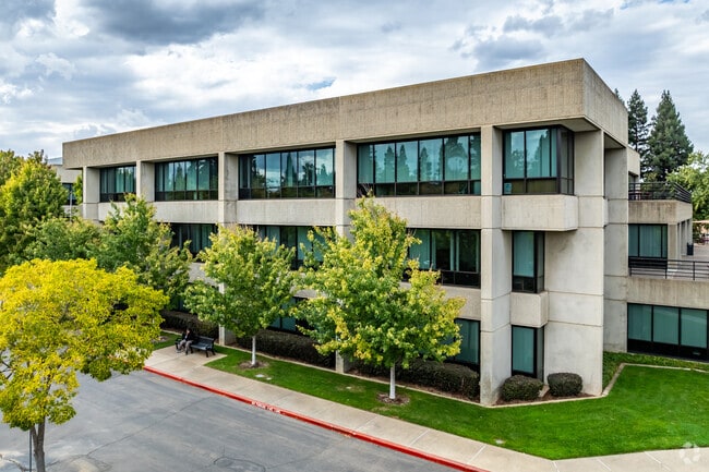

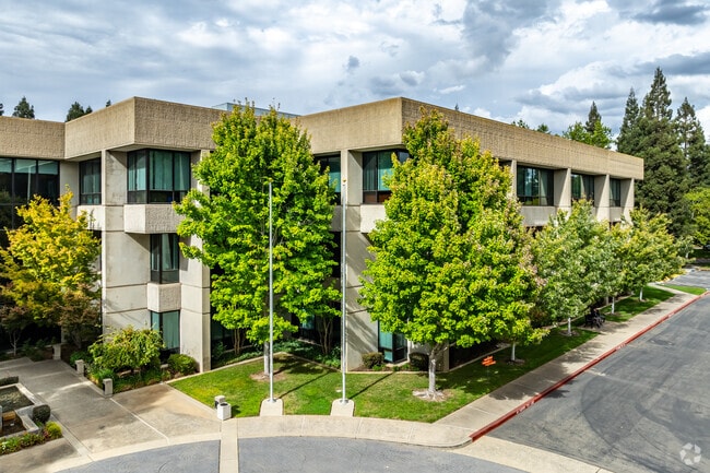

Property Detail
3400 Data Dr
072-0690-061
LOT 5 AND THE NLY 362.16 FT OF LOT 4 RECORDED IN PARCEL MAP BOOK 93 PG 7
Officebuilding
Sacramento
OPMU
California
B and X Area of moderate flood hazard, usually the area between the limits of the 100-year and 500-year floods.
5,4
2024
9.31 AC
2025
Highway 50 Corridor
009010
Sacramento
156,032 SF
Sacramento-Roseville-Folsom, CA
NEARBY LISTINGS FOR SALE OR LEASE
DEMOGRAPHICS near 3400 Data Dr
1 mile
3 mile
5 mile
2025 Total Population
22,237
83,800
220,897
2030 Population
22,517
84,800
223,836
Pop Growth 2025-2030
+ 1.26%
+ 1.19%
+ 1.33%
Average Age
37
40
41
2025 Total Households
8,189
31,016
84,490
HH Growth 2025-2030
+ 1.26%
+ 1.21%
+ 1.25%
Median Household Inc
$84,567
$87,185
$96,346
Avg Household Size
2.70
2.60
2.50
2025 Avg HH Vehicles
2.00
2.00
2.00
Median Home Value
$439,757
$471,343
$576,831
Median Year Built
1978
1975
1974
Nearby Places
Map Layers
Map Styles
 Street
 Aerial
Layers
 Traffic
 Biking
Places
Listings with unknown addresses are not visible on the map
- Restaurants
- Banks
- Shops
- Fitness
- Groceries
PUBLIC TRANSPORTATION
AIRPORT
Sacramento International
Drive
Walk
Distance
Sacramento International
35 min
25.1 mi
Freight Ports
Port of Stockton
Drive
Walk
Distance
Port of Stockton
70 min
58.7 mi
Nearby Properties
Address
Land Use
TOTAL SIZE
Lot Size
Zoning
Address
Land Use
TOTAL SIZE
Lot Size
Zoning
251,024 SF
5.19 AC
SPA (CVSPA
Address
Land Use
TOTAL SIZE
Lot Size
Zoning
83.57 AC
MP (RDOSP)
Address
Land Use
TOTAL SIZE
Lot Size
Zoning
223,046 SF
10.99 AC
RD 20
Address
Land Use
TOTAL SIZE
Lot Size
Zoning
109,805 SF
20.04 AC
OPMU
Address
Land Use
TOTAL SIZE
Lot Size
Zoning
181,573 SF
12.10 AC
SPA (MFSPA
Address
Land Use
TOTAL SIZE
Lot Size
Zoning
192,500 SF
11.78 AC
OPMU
Address
Land Use
TOTAL SIZE
Lot Size
Zoning
323,088 SF
19.69 AC
OPMU
Address
Land Use
TOTAL SIZE
Lot Size
Zoning
139,500 SF
5.21 AC
MP
Address
Land Use
TOTAL SIZE
Lot Size
Zoning
162,023 SF
8.96 AC
OIMU
Address
Land Use
TOTAL SIZE
Lot Size
Zoning
166,216 SF
10.77 AC
M-2
Address
Land Use
TOTAL SIZE
Lot Size
Zoning
0.21 AC
RD-5
Address
Land Use
TOTAL SIZE
Lot Size
Zoning
6.31 AC
RC (ZSPA)
Address
Land Use
TOTAL SIZE
Lot Size
Zoning
221,337 SF
12.19 AC
RD 25
Address
Land Use
TOTAL SIZE
Lot Size
Zoning
132,149 SF
8.29 AC
OPMU
Address
Land Use
TOTAL SIZE
Lot Size
Zoning
95,174 SF
5.29 AC
SPA (MFSPA
Address
Land Use
TOTAL SIZE
Lot Size
Zoning
218,216 SF
14.22 AC
OPMU
Address
Land Use
TOTAL SIZE
Lot Size
Zoning
198,413 SF
9.24 AC
RD 30
Address
Land Use
TOTAL SIZE
Lot Size
Zoning
104,042 SF
7.40 AC
OIMU
Address
Land Use
TOTAL SIZE
Lot Size
Zoning
135,197 SF
11.38 AC
SPA (CVSPA
Address
Land Use
TOTAL SIZE
Lot Size
Zoning
137,306 SF
15.91 AC
GC
Address
Land Use
TOTAL SIZE
Lot Size
Zoning
12.47 AC
RD 30
Address
Land Use
TOTAL SIZE
Lot Size
Zoning
457,088 SF
12.50 AC
RD 30
Address
Land Use
TOTAL SIZE
Lot Size
Zoning
98,767 SF
6.43 AC
BP (ZSPA)
Address
Land Use
TOTAL SIZE
Lot Size
Zoning
89,098 SF
4.93 AC
RD-40
Address
Land Use
TOTAL SIZE
Lot Size
Zoning
302,966 SF
15.94 AC
RD 30
Address
Land Use
TOTAL SIZE
Lot Size
Zoning
258,819 SF
13.47 AC
RD 30
Address
Land Use
TOTAL SIZE
Lot Size
Zoning
164,149 SF
9.31 AC
LI (ZSPA)
Address
Land Use
TOTAL SIZE
Lot Size
Zoning
12,988 SF
3.98 AC
M-2
Address
Land Use
TOTAL SIZE
Lot Size
Zoning
112,244 SF
3.55 AC
GC
The World's #1 Commercial Real Estate Marketplace
Connect with us
© 2026 CoStar Group
The information above has been obtained from sources believed reliable. While we do not doubt its accuracy we have not verified it and make no guarantee, warranty or representation about it. It is your responsibility to independently confirm its accuracy and completeness. Any projections, opinions, assumptions, or estimates used are for example only and do not represent the current or future performance of the property. The value of this transaction to you depends on tax and other factors which should be evaluated by your tax, financial, and legal advisors. You and your advisors should conduct a careful, independent investigation of the property to determine to your satisfaction the suitability of the property for your needs.