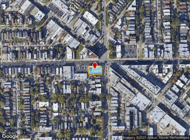
Property Record
2758 N Kimball Ave, Chicago, IL 60647

Current Lease Availabilities
NEARBY LISTINGS FOR SALE OR LEASE
Property Detail
2758 N Kimball Ave
13-26-402-031-0000
Storeys Milwaukee Ave Sub
Storebuilding
Cook
X
Illinois
17031C0415J
0.19 AC
2022
Northwest City
2024
Chicago
221300
Chicago-Naperville-Elgin, IL-IN-WI
16,198 SF
DEMOGRAPHICS near 2758 N Kimball Ave
1 Mile
3 Mile
5 Mile
2024 Total Population
55,779
466,690
1,197,874
2029 Population
51,920
439,009
1,145,338
Pop Growth 2024-2029
(6.92%)
(5.93%)
(4.39%)
Average Age
36
36
37
2024 Total Households
23,160
186,256
528,841
HH Growth 2024-2029
(7.21%)
(6.11%)
(4.29%)
Median Household Inc
$79,342
$87,635
$82,201
Avg Household Size
2.30
2.40
2.20
2024 Avg HH Vehicles
1.00
1.00
1.00
Median Home Value
$438,792
$445,970
$398,219
Median Year Built
1946
1947
1949
Nearby Places
- Restaurants
- Banks
- Shops
- Fitness
- Groceries
PUBLIC TRANSPORTATION
TRANSIT/SUBWAY
Logan Square Station (Blue Line - Chicago Transit Authority "L" Trains (The "L"))
DRIVE
WALK
Distance
Logan Square Station (Blue Line - Chicago Transit Authority "L" Trains (The "L"))
0 min
6 min
0.3 mi
Belmont Station (Blue Line) (Blue Line - Chicago Transit Authority "L" Trains (The "L"))
DRIVE
WALK
Distance
Belmont Station (Blue Line) (Blue Line - Chicago Transit Authority "L" Trains (The "L"))
2 min
10 min
0.5 mi
California Station (Blue Line - O'hare Branch) (Blue Line - Chicago Transit Authority "L" Trains (The "L"))
DRIVE
WALK
Distance
California Station (Blue Line - O'hare Branch) (Blue Line - Chicago Transit Authority "L" Trains (The "L"))
2 min
20 min
1.1 mi
COMMUTER RAIL
Healy Station (Milwaukee District North Line - Northeast Illinois Regional Commuter Railroad (Metra))
DRIVE
WALK
Distance
Healy Station (Milwaukee District North Line - Northeast Illinois Regional Commuter Railroad (Metra))
3 min
1.3 mi
Irving Park Station (Union Pacific Northwest Line - Northeast Illinois Regional Commuter Railroad (Metra))
DRIVE
WALK
Distance
Irving Park Station (Union Pacific Northwest Line - Northeast Illinois Regional Commuter Railroad (Metra))
4 min
2.1 mi
AIRPORT
Chicago Midway International
DRIVE
WALK
Distance
Chicago Midway International
22 min
11.8 mi
Chicago O'Hare International
DRIVE
WALK
Distance
Chicago O'Hare International
20 min
12.1 mi
Freight Ports
Port Milwaukee
DRIVE
WALK
Distance
Port Milwaukee
98 min
80.4 mi
Nearby Properties
Address
Land Use
TOTAL SIZE
Lot Size
Zoning
Address
Land Use
TOTAL SIZE
Lot Size
Zoning
222,240 SF
2.45 AC
PD 1439
Address
Land Use
TOTAL SIZE
Lot Size
Zoning
16.93 AC
POS-1,PD 1
Address
Land Use
TOTAL SIZE
Lot Size
Zoning
19,500 SF
12.06 AC
PD 367
Address
Land Use
TOTAL SIZE
Lot Size
Zoning
0.66 AC
RS-3
Address
Land Use
TOTAL SIZE
Lot Size
Zoning
237,832 SF
14.04 AC
PD 418
Address
Land Use
TOTAL SIZE
Lot Size
Zoning
82,000 SF
9.68 AC
PD 437
Address
Land Use
TOTAL SIZE
Lot Size
Zoning
170,538 SF
0.76 AC
PD 112
Address
Land Use
TOTAL SIZE
Lot Size
Zoning
331,294 SF
13.03 AC
PD 439
Address
Land Use
TOTAL SIZE
Lot Size
Zoning
277,195 SF
1.78 AC
PD 1094
Address
Land Use
TOTAL SIZE
Lot Size
Zoning
190,011 SF
5.90 AC
PD 353
Address
Land Use
TOTAL SIZE
Lot Size
Zoning
140,451 SF
9.48 AC
PD 213
Address
Land Use
TOTAL SIZE
Lot Size
Zoning
311,556 SF
PD 1420
Address
Land Use
TOTAL SIZE
Lot Size
Zoning
2.25 AC
PD 612
Address
Land Use
TOTAL SIZE
Lot Size
Zoning
382,635 SF
5.90 AC
M1-1
Address
Land Use
TOTAL SIZE
Lot Size
Zoning
55,476 SF
6.16 AC
PD 619
Address
Land Use
TOTAL SIZE
Lot Size
Zoning
194,582 SF
12.68 AC
PD 699
Address
Land Use
TOTAL SIZE
Lot Size
Zoning
85,214 SF
1.25 AC
PD 940
Address
Land Use
TOTAL SIZE
Lot Size
Zoning
32,500 SF
0.56 AC
RT-4
Address
Land Use
TOTAL SIZE
Lot Size
Zoning
15,600 SF
0.77 AC
M1-1
Address
Land Use
TOTAL SIZE
Lot Size
Zoning
340,838 SF
31 AC
PD 1411
Address
Land Use
TOTAL SIZE
Lot Size
Zoning
522,886 SF
5.72 AC
POS-1,M2-2
Address
Land Use
TOTAL SIZE
Lot Size
Zoning
171,800 SF
5.09 AC
M2-3
Address
Land Use
TOTAL SIZE
Lot Size
Zoning
7.20 AC
PD 728
Address
Land Use
TOTAL SIZE
Lot Size
Zoning
211,025 SF
6.90 AC
PD 437
Address
Land Use
TOTAL SIZE
Lot Size
Zoning
78,410 SF
4.87 AC
PD 171
Address
Land Use
TOTAL SIZE
Lot Size
Zoning
109,176 SF
6.54 AC
B1-1
Address
Land Use
TOTAL SIZE
Lot Size
Zoning
389,400 SF
28.83 AC
PMD 9
Address
Land Use
TOTAL SIZE
Lot Size
Zoning
1.57 AC
PD 1052
Address
Land Use
TOTAL SIZE
Lot Size
Zoning
123,185 SF
7.98 AC
PD 752
Address
Land Use
TOTAL SIZE
Lot Size
Zoning
179,150 SF
15.56 AC
PD 903
The World's #1 Commercial Real Estate Marketplace
Connect with us
© 2025 CoStar Group
The information above has been obtained from sources believed reliable. While we do not doubt its accuracy we have not verified it and make no guarantee, warranty or representation about it. It is your responsibility to independently confirm its accuracy and completeness. Any projections, opinions, assumptions, or estimates used are for example only and do not represent the current or future performance of the property. The value of this transaction to you depends on tax and other factors which should be evaluated by your tax, financial, and legal advisors. You and your advisors should conduct a careful, independent investigation of the property to determine to your satisfaction the suitability of the property for your needs.