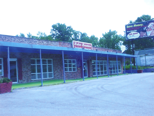
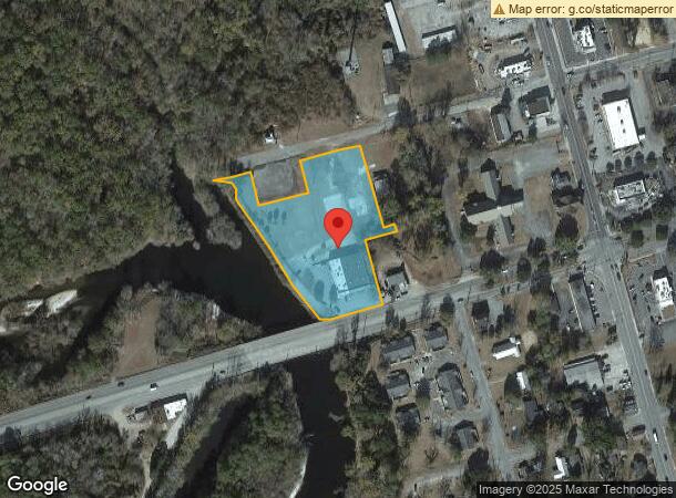
Property Record
342 W Main St, Kingstree, SC 29556
NEARBY LISTINGS FOR SALE OR LEASE
Property Detail
342 W Main St
Commercialnec
N HWY 52
AE
Williamsburg
45089C0262E
South Carolina
2024
0.90 AC
2024
Other Market Areas
970601
11-014-020
930 SF
DEMOGRAPHICS near 342 W Main St
1 Mile
3 Mile
5 Mile
2024 Total Population
2,057
6,753
9,594
2029 Population
1,989
6,548
9,304
Pop Growth 2024-2029
(3.31%)
(3.04%)
(3.02%)
Average Age
42
42
42
2024 Total Households
881
2,835
4,049
HH Growth 2024-2029
(2.95%)
(2.79%)
(2.79%)
Median Household Inc
$32,672
$38,692
$41,327
Avg Household Size
2.20
2.30
2.30
2024 Avg HH Vehicles
1.00
1.00
2.00
Median Home Value
$109,352
$85,239
$79,035
Median Year Built
1974
1980
1981
Nearby Places
- Restaurants
- Banks
- Shops
- Fitness
- Groceries
PUBLIC TRANSPORTATION
COMMUTER RAIL
Kingstree Amtrak Station (Palmetto - Amtrak, Silver Meteor - Amtrak)
DRIVE
WALK
Distance
Kingstree Amtrak Station (Palmetto - Amtrak, Silver Meteor - Amtrak)
0 min
10 min
0.4 mi
Freight Ports
North Charleston Terminal
DRIVE
WALK
Distance
North Charleston Terminal
83 min
63.8 mi
Nearby Properties
Address
Land Use
TOTAL SIZE
Lot Size
Zoning
Address
Land Use
TOTAL SIZE
Lot Size
Zoning
Address
Land Use
TOTAL SIZE
Lot Size
Zoning
Address
Land Use
TOTAL SIZE
Lot Size
Zoning
Address
Land Use
TOTAL SIZE
Lot Size
Zoning
Address
Land Use
TOTAL SIZE
Lot Size
Zoning
7,056 SF
Address
Land Use
TOTAL SIZE
Lot Size
Zoning
43.50 AC
Address
Land Use
TOTAL SIZE
Lot Size
Zoning
54.66 AC
Address
Land Use
TOTAL SIZE
Lot Size
Zoning
Address
Land Use
TOTAL SIZE
Lot Size
Zoning
6,216 SF
Address
Land Use
TOTAL SIZE
Lot Size
Zoning
19,016 SF
Address
Land Use
TOTAL SIZE
Lot Size
Zoning
2,368 SF
0.06 AC
Address
Land Use
TOTAL SIZE
Lot Size
Zoning
Address
Land Use
TOTAL SIZE
Lot Size
Zoning
Address
Land Use
TOTAL SIZE
Lot Size
Zoning
Address
Land Use
TOTAL SIZE
Lot Size
Zoning
3.60 AC
Address
Land Use
TOTAL SIZE
Lot Size
Zoning
Address
Land Use
TOTAL SIZE
Lot Size
Zoning
15.74 AC
Address
Land Use
TOTAL SIZE
Lot Size
Zoning
20,670 SF
Address
Land Use
TOTAL SIZE
Lot Size
Zoning
Address
Land Use
TOTAL SIZE
Lot Size
Zoning
Address
Land Use
TOTAL SIZE
Lot Size
Zoning
Address
Land Use
TOTAL SIZE
Lot Size
Zoning
4,004 SF
3.90 AC
Address
Land Use
TOTAL SIZE
Lot Size
Zoning
Address
Land Use
TOTAL SIZE
Lot Size
Zoning
Address
Land Use
TOTAL SIZE
Lot Size
Zoning
18,780 SF
1.21 AC
Address
Land Use
TOTAL SIZE
Lot Size
Zoning
2.10 AC
Address
Land Use
TOTAL SIZE
Lot Size
Zoning
Address
Land Use
TOTAL SIZE
Lot Size
Zoning
3,900 SF
4.20 AC
Address
Land Use
TOTAL SIZE
Lot Size
Zoning
Address
Land Use
TOTAL SIZE
Lot Size
Zoning
11,518 SF
1.50 AC
The World's #1 Commercial Real Estate Marketplace
Connect with us
© 2025 CoStar Group
The information above has been obtained from sources believed reliable. While we do not doubt its accuracy we have not verified it and make no guarantee, warranty or representation about it. It is your responsibility to independently confirm its accuracy and completeness. Any projections, opinions, assumptions, or estimates used are for example only and do not represent the current or future performance of the property. The value of this transaction to you depends on tax and other factors which should be evaluated by your tax, financial, and legal advisors. You and your advisors should conduct a careful, independent investigation of the property to determine to your satisfaction the suitability of the property for your needs.