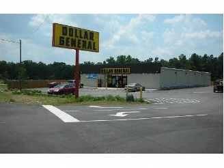
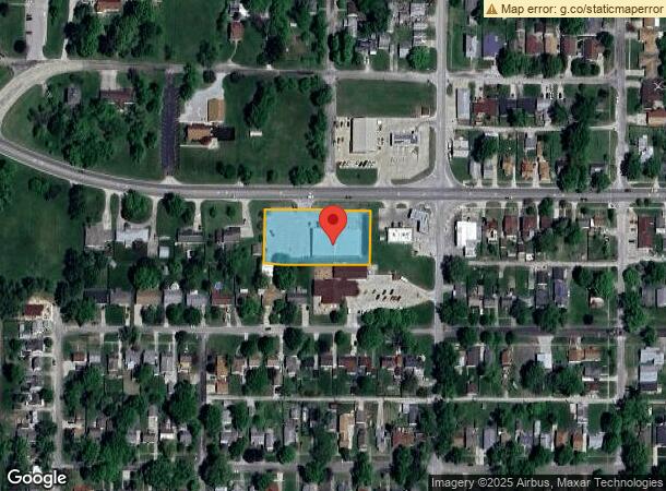
Property Record
3425 Dewitt Ave, Mattoon, IL 61938
NEARBY LISTINGS FOR SALE OR LEASE
Property Detail
3425 Dewitt Ave
07-2-13625-000
Podeschis Addition
Commercialnec
PODESCHIS ADDITION E1/2 OF LOT 2 & ALL OF LOT 3 NE 1/4 SEC 15 T12N R07E
X
Coles
17029C0260D
Illinois
2022
2-3
2023
1.01 AC
001100
Other Market Areas
9,230 SF
Charleston-Mattoon, IL
DEMOGRAPHICS near 3425 Dewitt Ave
1 Mile
3 Mile
5 Mile
2024 Total Population
5,430
16,208
18,679
2029 Population
5,328
15,897
18,311
Pop Growth 2024-2029
(1.88%)
(1.92%)
(1.97%)
Average Age
41
42
42
2024 Total Households
2,353
7,262
8,284
HH Growth 2024-2029
(2.08%)
(2.12%)
(2.15%)
Median Household Inc
$49,701
$43,992
$45,710
Avg Household Size
2.20
2.10
2.20
2024 Avg HH Vehicles
2.00
2.00
2.00
Median Home Value
$84,903
$81,551
$89,282
Median Year Built
1951
1956
1958
Nearby Places
- Restaurants
- Banks
- Shops
- Fitness
- Groceries
PUBLIC TRANSPORTATION
COMMUTER RAIL
Mattoon Amtrak Station (City of New Orleans - Amtrak, Illini - Amtrak, Saluki - Amtrak)
DRIVE
WALK
Distance
Mattoon Amtrak Station (City of New Orleans - Amtrak, Illini - Amtrak, Saluki - Amtrak)
2 min
1.6 mi
Freight Ports
Port Milwaukee
DRIVE
WALK
Distance
Port Milwaukee
312 min
270.6 mi
Nearby Properties
Address
Land Use
TOTAL SIZE
Lot Size
Zoning
Address
Land Use
TOTAL SIZE
Lot Size
Zoning
290,500 SF
30.27 AC
Address
Land Use
TOTAL SIZE
Lot Size
Zoning
7,500 SF
26.72 AC
Address
Land Use
TOTAL SIZE
Lot Size
Zoning
0.92 AC
Address
Land Use
TOTAL SIZE
Lot Size
Zoning
4,500 SF
13.35 AC
Address
Land Use
TOTAL SIZE
Lot Size
Zoning
208,184 SF
30.37 AC
Address
Land Use
TOTAL SIZE
Lot Size
Zoning
43,613 SF
1.03 AC
Address
Land Use
TOTAL SIZE
Lot Size
Zoning
Address
Land Use
TOTAL SIZE
Lot Size
Zoning
3,360 SF
5.96 AC
Address
Land Use
TOTAL SIZE
Lot Size
Zoning
9,888 SF
1.17 AC
Address
Land Use
TOTAL SIZE
Lot Size
Zoning
31,026 SF
34.80 AC
Address
Land Use
TOTAL SIZE
Lot Size
Zoning
149,715 SF
56.72 AC
Address
Land Use
TOTAL SIZE
Lot Size
Zoning
41,673 SF
5.40 AC
Address
Land Use
TOTAL SIZE
Lot Size
Zoning
2,580 SF
13.07 AC
Address
Land Use
TOTAL SIZE
Lot Size
Zoning
19,320 SF
1.44 AC
Address
Land Use
TOTAL SIZE
Lot Size
Zoning
38,486 SF
4.99 AC
Address
Land Use
TOTAL SIZE
Lot Size
Zoning
68,424 SF
5 AC
Address
Land Use
TOTAL SIZE
Lot Size
Zoning
25,576 SF
6.60 AC
Address
Land Use
TOTAL SIZE
Lot Size
Zoning
38,414 SF
5.21 AC
Address
Land Use
TOTAL SIZE
Lot Size
Zoning
62,944 SF
0.80 AC
Address
Land Use
TOTAL SIZE
Lot Size
Zoning
27,534 SF
0.32 AC
Address
Land Use
TOTAL SIZE
Lot Size
Zoning
38,463 SF
0.32 AC
Address
Land Use
TOTAL SIZE
Lot Size
Zoning
3.50 AC
Address
Land Use
TOTAL SIZE
Lot Size
Zoning
Address
Land Use
TOTAL SIZE
Lot Size
Zoning
21.27 AC
Address
Land Use
TOTAL SIZE
Lot Size
Zoning
20,610 SF
3.28 AC
Address
Land Use
TOTAL SIZE
Lot Size
Zoning
11,268 SF
6 AC
Address
Land Use
TOTAL SIZE
Lot Size
Zoning
22,310 SF
1.27 AC
Address
Land Use
TOTAL SIZE
Lot Size
Zoning
2,544 SF
23.59 AC
Address
Land Use
TOTAL SIZE
Lot Size
Zoning
54,394 SF
4.40 AC
Address
Land Use
TOTAL SIZE
Lot Size
Zoning
23,562 SF
1.03 AC
The World's #1 Commercial Real Estate Marketplace
Connect with us
© 2025 CoStar Group
The information above has been obtained from sources believed reliable. While we do not doubt its accuracy we have not verified it and make no guarantee, warranty or representation about it. It is your responsibility to independently confirm its accuracy and completeness. Any projections, opinions, assumptions, or estimates used are for example only and do not represent the current or future performance of the property. The value of this transaction to you depends on tax and other factors which should be evaluated by your tax, financial, and legal advisors. You and your advisors should conduct a careful, independent investigation of the property to determine to your satisfaction the suitability of the property for your needs.