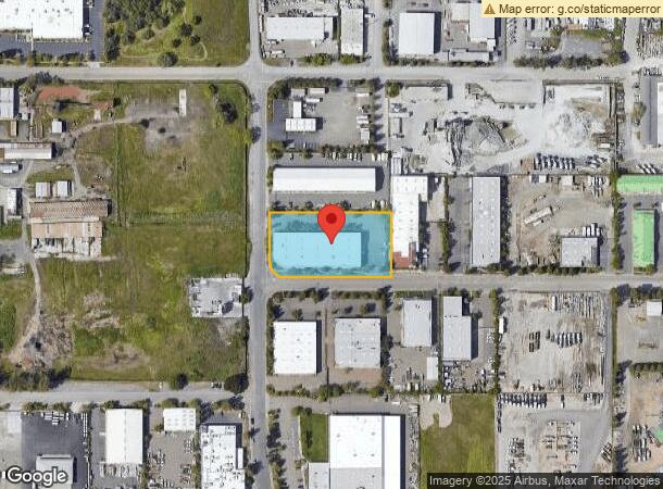
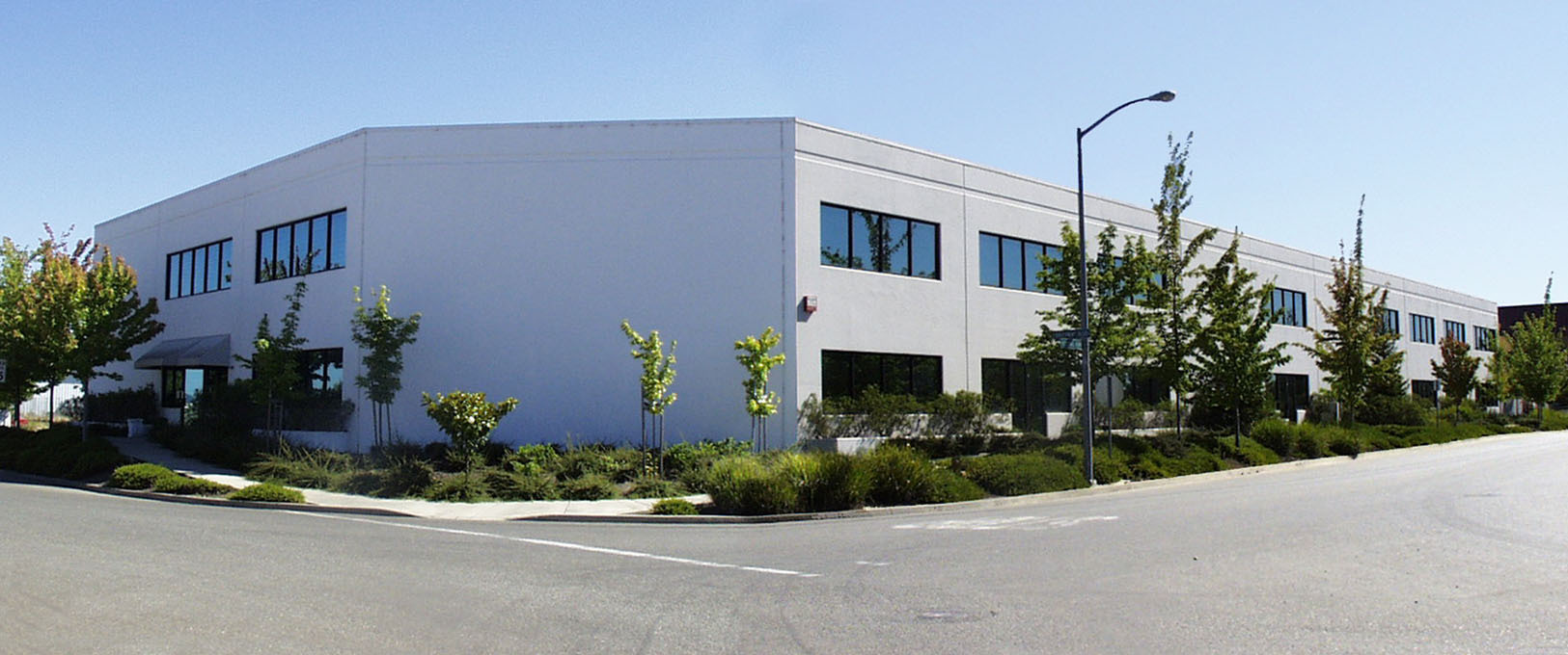
Property Record
3430 Brickway Blvd, Santa Rosa, CA 95403

Current Lease Availabilities
NEARBY LISTINGS FOR SALE OR LEASE
Property Detail
3430 Brickway Blvd
Santa Rosa, CA
Northwest Regional Industrial Park
059-210-021
NORTHWEST REGIONAL INDUSTRIAL PARK U3 PH 2 LOT 12
Warehouse
Sonoma
X
California
06097C0568F
12
2023
1.43 AC
2023
Healdsburg/Cloverdale
1527021020
North Bay/Santa Rosa
23,047 SF
DEMOGRAPHICS near 3430 Brickway Blvd
1 Mile
3 Mile
5 Mile
2024 Total Population
1,017
30,698
92,693
2029 Population
976
30,323
91,992
Pop Growth 2024-2029
(4.03%)
(1.22%)
(0.76%)
Average Age
41
42
42
2024 Total Households
395
11,132
33,810
HH Growth 2024-2029
(4.30%)
(1.33%)
(0.66%)
Median Household Inc
$90,163
$114,389
$106,760
Avg Household Size
2.30
2.70
2.60
2024 Avg HH Vehicles
2.00
2.00
2.00
Median Home Value
$747,916
$741,294
$739,671
Median Year Built
1980
1989
1986
Nearby Places
- Restaurants
- Banks
- Shops
- Fitness
- Groceries
PUBLIC TRANSPORTATION
COMMUTER RAIL
Sonoma County Airport Smart (Main Line - Sonoma Marin Area Rail Transit)
DRIVE
WALK
Distance
Sonoma County Airport Smart (Main Line - Sonoma Marin Area Rail Transit)
2 min
15 min
0.6 mi
Santa Rosa North Smart (Main Line - Sonoma Marin Area Rail Transit)
DRIVE
WALK
Distance
Santa Rosa North Smart (Main Line - Sonoma Marin Area Rail Transit)
10 min
6.6 mi
AIRPORT
Charles M Schulz - Sonoma County
DRIVE
WALK
Distance
Charles M Schulz - Sonoma County
3 min
1.2 mi
Freight Ports
Port of Richmond
DRIVE
WALK
Distance
Port of Richmond
71 min
55.7 mi
Nearby Properties
Address
Land Use
TOTAL SIZE
Lot Size
Zoning
Address
Land Use
TOTAL SIZE
Lot Size
Zoning
Address
Land Use
TOTAL SIZE
Lot Size
Zoning
46,737 SF
80 AC
DA60
Address
Land Use
TOTAL SIZE
Lot Size
Zoning
285,710 SF
10.38 AC
Address
Land Use
TOTAL SIZE
Lot Size
Zoning
14.56 AC
Address
Land Use
TOTAL SIZE
Lot Size
Zoning
249,088 SF
10.75 AC
Address
Land Use
TOTAL SIZE
Lot Size
Zoning
126,123 SF
7.66 AC
Address
Land Use
TOTAL SIZE
Lot Size
Zoning
80,017 SF
0.78 AC
Address
Land Use
TOTAL SIZE
Lot Size
Zoning
75,540 SF
9.98 AC
Address
Land Use
TOTAL SIZE
Lot Size
Zoning
93,886 SF
5.40 AC
MP2
Address
Land Use
TOTAL SIZE
Lot Size
Zoning
14.29 AC
Address
Land Use
TOTAL SIZE
Lot Size
Zoning
232,262 SF
30.69 AC
Address
Land Use
TOTAL SIZE
Lot Size
Zoning
163,194 SF
15.09 AC
Address
Land Use
TOTAL SIZE
Lot Size
Zoning
129,726 SF
12.47 AC
Address
Land Use
TOTAL SIZE
Lot Size
Zoning
94,768 SF
5.44 AC
R211UA
Address
Land Use
TOTAL SIZE
Lot Size
Zoning
70,358 SF
4.51 AC
M1
Address
Land Use
TOTAL SIZE
Lot Size
Zoning
146,448 SF
84.59 AC
Address
Land Use
TOTAL SIZE
Lot Size
Zoning
282,600 SF
6.89 AC
Address
Land Use
TOTAL SIZE
Lot Size
Zoning
35,648 SF
2.26 AC
M1
Address
Land Use
TOTAL SIZE
Lot Size
Zoning
195,243 SF
12.31 AC
Address
Land Use
TOTAL SIZE
Lot Size
Zoning
134,209 SF
11.02 AC
Address
Land Use
TOTAL SIZE
Lot Size
Zoning
69,962 SF
4.49 AC
Address
Land Use
TOTAL SIZE
Lot Size
Zoning
63,890 SF
3.72 AC
Address
Land Use
TOTAL SIZE
Lot Size
Zoning
63,890 SF
4.05 AC
Address
Land Use
TOTAL SIZE
Lot Size
Zoning
98,033 SF
1.39 AC
Address
Land Use
TOTAL SIZE
Lot Size
Zoning
80,808 SF
6.92 AC
Address
Land Use
TOTAL SIZE
Lot Size
Zoning
109,845 SF
6.05 AC
Address
Land Use
TOTAL SIZE
Lot Size
Zoning
59,504 SF
3.41 AC
Address
Land Use
TOTAL SIZE
Lot Size
Zoning
134,241 SF
7.23 AC
Address
Land Use
TOTAL SIZE
Lot Size
Zoning
74,665 SF
4.90 AC
M1
Address
Land Use
TOTAL SIZE
Lot Size
Zoning
152,580 SF
6.53 AC
The World's #1 Commercial Real Estate Marketplace
Connect with us
© 2025 CoStar Group
The information above has been obtained from sources believed reliable. While we do not doubt its accuracy we have not verified it and make no guarantee, warranty or representation about it. It is your responsibility to independently confirm its accuracy and completeness. Any projections, opinions, assumptions, or estimates used are for example only and do not represent the current or future performance of the property. The value of this transaction to you depends on tax and other factors which should be evaluated by your tax, financial, and legal advisors. You and your advisors should conduct a careful, independent investigation of the property to determine to your satisfaction the suitability of the property for your needs.