Property Record
3450 Kaiser Ave, Saint Cloud, FL 34772
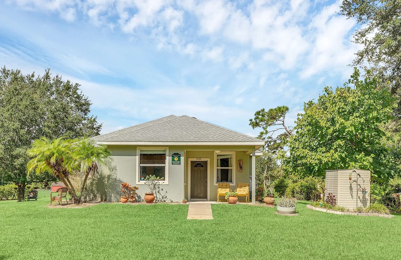
This Property Is For Sale
NEARBY LISTINGS FOR SALE OR LEASE
-
-
View all Saint Cloud listings for sale on LoopNet.com
Property Detail
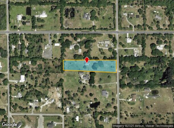
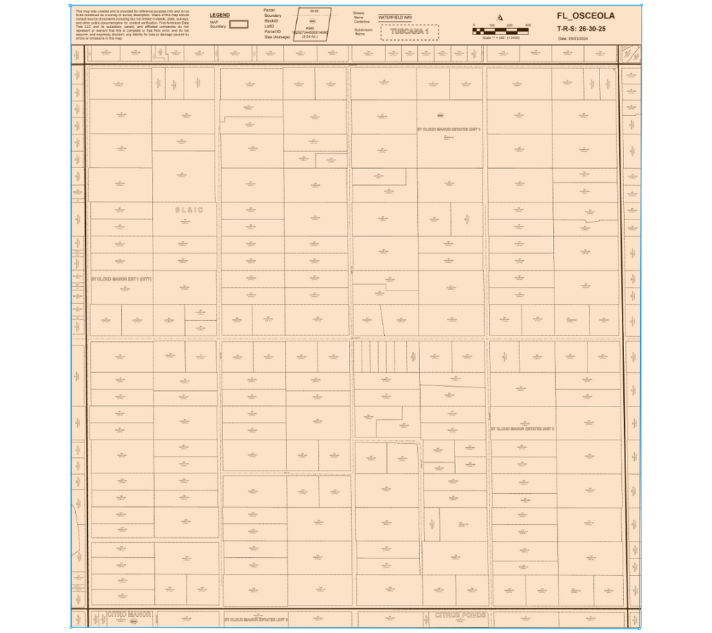
3450 Kaiser Ave
Orlando-Kissimmee-Sanford, FL
St Cloud Manor Estates Unit 2
25-26-30-5080-0001-0785
ST CLOUD MANOR EST UNIT 2 PB 1 PG 365 BEG AT NE COR LOT 78, W 644.17 FT TO NW COR, S 120.45 FT, S 87 DEG E 644.66 FT, N 150 FT TO POB LESS E 5 FT & SUBJ TO RD R/W OVER E 10 FT
Hospitalprivate
Osceola
X
Florida
12097C0260G
78
2023
1.98 AC
2024
Osceola Outlying
043304
Orlando
1,316 SF
DEMOGRAPHICS near 3450 Kaiser Ave
1 Mile
3 Mile
5 Mile
2024 Total Population
2,187
37,087
71,150
2029 Population
2,630
44,697
84,951
Pop Growth 2024-2029
+ 20.26%
+ 20.52%
+ 19.40%
Average Age
37
38
39
2024 Total Households
694
11,948
24,397
HH Growth 2024-2029
+ 20.03%
+ 20.74%
+ 19.26%
Median Household Inc
$72,935
$75,851
$69,242
Avg Household Size
3.10
3.10
2.90
2024 Avg HH Vehicles
2.00
2.00
2.00
Median Home Value
$282,706
$302,683
$299,038
Median Year Built
2009
2009
2003
Nearby Places
- Restaurants
- Banks
- Shops
- Fitness
- Groceries
PUBLIC TRANSPORTATION
AIRPORT
Orlando International
DRIVE
WALK
Distance
Orlando International
38 min
25.8 mi
Freight Ports
Port Canaveral
DRIVE
WALK
Distance
Port Canaveral
82 min
59.1 mi
Nearby Properties
Address
Land Use
TOTAL SIZE
Lot Size
Zoning
Address
Land Use
TOTAL SIZE
Lot Size
Zoning
102,869 SF
1.71 AC
Address
Land Use
TOTAL SIZE
Lot Size
Zoning
68,306 SF
9.59 AC
SPUD
Address
Land Use
TOTAL SIZE
Lot Size
Zoning
71,784 SF
7.87 AC
SPUD
Address
Land Use
TOTAL SIZE
Lot Size
Zoning
59,852 SF
8.13 AC
SHB
Address
Land Use
TOTAL SIZE
Lot Size
Zoning
103.75 AC
Address
Land Use
TOTAL SIZE
Lot Size
Zoning
70,375 SF
4.58 AC
OAR2
Address
Land Use
TOTAL SIZE
Lot Size
Zoning
50,725 SF
29.07 AC
SR1B
Address
Land Use
TOTAL SIZE
Lot Size
Zoning
14,761 SF
1.86 AC
SHB
Address
Land Use
TOTAL SIZE
Lot Size
Zoning
75.78 AC
Address
Land Use
TOTAL SIZE
Lot Size
Zoning
16.98 AC
Address
Land Use
TOTAL SIZE
Lot Size
Zoning
46,404 SF
29.13 AC
SP
Address
Land Use
TOTAL SIZE
Lot Size
Zoning
50,442 SF
13.86 AC
E-1
Address
Land Use
TOTAL SIZE
Lot Size
Zoning
49.53 AC
Address
Land Use
TOTAL SIZE
Lot Size
Zoning
1,148 SF
56.79 AC
OAC
Address
Land Use
TOTAL SIZE
Lot Size
Zoning
25,232 SF
254.03 AC
SAC
Address
Land Use
TOTAL SIZE
Lot Size
Zoning
42,412 SF
6.30 AC
Address
Land Use
TOTAL SIZE
Lot Size
Zoning
16,740 SF
1.73 AC
SHB
Address
Land Use
TOTAL SIZE
Lot Size
Zoning
38.63 AC
AC
Address
Land Use
TOTAL SIZE
Lot Size
Zoning
28,712 SF
8.78 AC
OARM
Address
Land Use
TOTAL SIZE
Lot Size
Zoning
335.88 AC
OAC
Address
Land Use
TOTAL SIZE
Lot Size
Zoning
50.07 AC
Address
Land Use
TOTAL SIZE
Lot Size
Zoning
4,080 SF
1.47 AC
SHB
Address
Land Use
TOTAL SIZE
Lot Size
Zoning
12,618 SF
9.66 AC
OPUD
Address
Land Use
TOTAL SIZE
Lot Size
Zoning
227.80 AC
Address
Land Use
TOTAL SIZE
Lot Size
Zoning
17,816 SF
14.64 AC
SP
Address
Land Use
TOTAL SIZE
Lot Size
Zoning
3,124 SF
1.76 AC
OCN
Address
Land Use
TOTAL SIZE
Lot Size
Zoning
8,352 SF
2.03 AC
SPUD
Address
Land Use
TOTAL SIZE
Lot Size
Zoning
10,560 SF
0.89 AC
The World's #1 Commercial Real Estate Marketplace
Connect with us
© 2025 CoStar Group
The information above has been obtained from sources believed reliable. While we do not doubt its accuracy we have not verified it and make no guarantee, warranty or representation about it. It is your responsibility to independently confirm its accuracy and completeness. Any projections, opinions, assumptions, or estimates used are for example only and do not represent the current or future performance of the property. The value of this transaction to you depends on tax and other factors which should be evaluated by your tax, financial, and legal advisors. You and your advisors should conduct a careful, independent investigation of the property to determine to your satisfaction the suitability of the property for your needs.