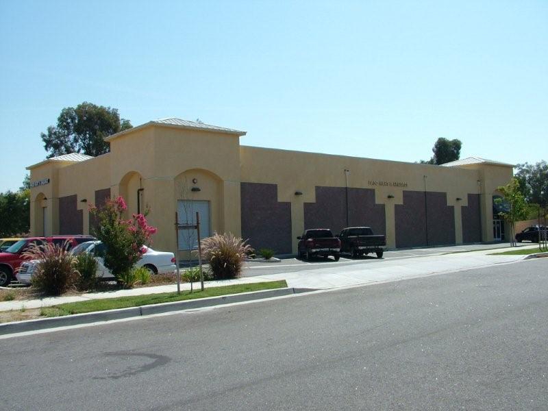
Property Record
3450 Riverside Ave, Paso Robles, CA 93446
NEARBY LISTINGS FOR SALE OR LEASE
Property Detail
3450 Riverside Ave
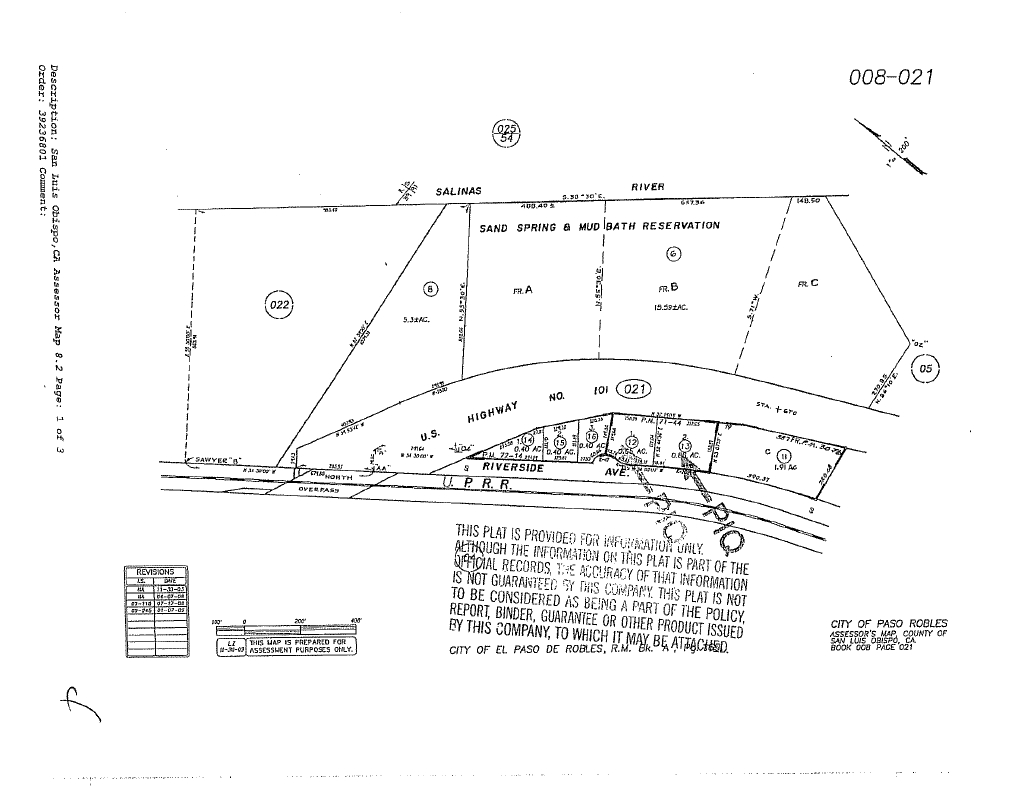
008-021-013
Parcel Map Pr 7-0065
Commercialnec
CY PR PM 71/44-45 PAR 2
X
San Luis Obispo
06079C0389H
California
2023
0.86 AC
2024
North 101 Corridor
010104
San Luis Obispo/Paso Robles
10,336 SF
San Luis Obispo-Paso Robles-Arroyo Grande, CA
DEMOGRAPHICS near 3450 Riverside Ave
1 Mile
3 Mile
5 Mile
2024 Total Population
5,444
23,014
34,753
2029 Population
5,389
22,875
34,438
Pop Growth 2024-2029
(1.01%)
(0.60%)
(0.91%)
Average Age
37
40
40
2024 Total Households
1,992
8,588
12,816
HH Growth 2024-2029
(1.26%)
(0.75%)
(1.07%)
Median Household Inc
$64,836
$79,242
$78,891
Avg Household Size
2.70
2.60
2.70
2024 Avg HH Vehicles
2.00
2.00
2.00
Median Home Value
$679,411
$650,310
$630,874
Median Year Built
1988
1985
1986
Nearby Places
- Restaurants
- Banks
- Shops
- Fitness
- Groceries
PUBLIC TRANSPORTATION
COMMUTER RAIL
Paso Robles Amtrak Station (Coast Starlight - Amtrak)
DRIVE
WALK
Distance
Paso Robles Amtrak Station (Coast Starlight - Amtrak)
4 min
2.1 mi
AIRPORT
San Luis County Regional
DRIVE
WALK
Distance
San Luis County Regional
47 min
35.7 mi
Freight Ports
The Port of Hueneme
DRIVE
WALK
Distance
The Port of Hueneme
204 min
162.7 mi
Nearby Properties
Address
Land Use
TOTAL SIZE
Lot Size
Zoning
Address
Land Use
TOTAL SIZE
Lot Size
Zoning
197,140 SF
11.87 AC
R3
Address
Land Use
TOTAL SIZE
Lot Size
Zoning
115,054 SF
18.24 AC
PM
Address
Land Use
TOTAL SIZE
Lot Size
Zoning
282,906 SF
10 AC
R4
Address
Land Use
TOTAL SIZE
Lot Size
Zoning
129,241 SF
18.91 AC
POS
Address
Land Use
TOTAL SIZE
Lot Size
Zoning
72,406 SF
4.87 AC
OP
Address
Land Use
TOTAL SIZE
Lot Size
Zoning
63.59 AC
POS
Address
Land Use
TOTAL SIZE
Lot Size
Zoning
42,617 SF
4.79 AC
PM
Address
Land Use
TOTAL SIZE
Lot Size
Zoning
91,903 SF
5.10 AC
POS
Address
Land Use
TOTAL SIZE
Lot Size
Zoning
4.57 AC
PM
Address
Land Use
TOTAL SIZE
Lot Size
Zoning
48.88 AC
R1
Address
Land Use
TOTAL SIZE
Lot Size
Zoning
92,102 SF
2.79 AC
R4
Address
Land Use
TOTAL SIZE
Lot Size
Zoning
11.53 AC
C3
Address
Land Use
TOTAL SIZE
Lot Size
Zoning
73,236 SF
2.45 AC
TC2
Address
Land Use
TOTAL SIZE
Lot Size
Zoning
82,249 SF
6.67 AC
Address
Land Use
TOTAL SIZE
Lot Size
Zoning
58,884 SF
2.34 AC
T4N
Address
Land Use
TOTAL SIZE
Lot Size
Zoning
4.25 AC
Address
Land Use
TOTAL SIZE
Lot Size
Zoning
65,931 SF
3.16 AC
PM
Address
Land Use
TOTAL SIZE
Lot Size
Zoning
89,417 SF
3.13 AC
T4N
Address
Land Use
TOTAL SIZE
Lot Size
Zoning
12.56 AC
CR
Address
Land Use
TOTAL SIZE
Lot Size
Zoning
1.59 AC
C3
Address
Land Use
TOTAL SIZE
Lot Size
Zoning
5.94 AC
R2
Address
Land Use
TOTAL SIZE
Lot Size
Zoning
18,400 SF
2.42 AC
TC1
Address
Land Use
TOTAL SIZE
Lot Size
Zoning
89,400 SF
7.97 AC
RC
Address
Land Use
TOTAL SIZE
Lot Size
Zoning
64,323 SF
2.56 AC
T4N
Address
Land Use
TOTAL SIZE
Lot Size
Zoning
4.60 AC
CP
Address
Land Use
TOTAL SIZE
Lot Size
Zoning
28,050 SF
2.01 AC
PM
Address
Land Use
TOTAL SIZE
Lot Size
Zoning
44,636 SF
2.81 AC
TC2
Address
Land Use
TOTAL SIZE
Lot Size
Zoning
32,698 SF
3.45 AC
R1
Address
Land Use
TOTAL SIZE
Lot Size
Zoning
54,961 SF
2.93 AC
T4N
Address
Land Use
TOTAL SIZE
Lot Size
Zoning
5.90 AC
R2
The World's #1 Commercial Real Estate Marketplace
Connect with us
© 2025 CoStar Group
The information above has been obtained from sources believed reliable. While we do not doubt its accuracy we have not verified it and make no guarantee, warranty or representation about it. It is your responsibility to independently confirm its accuracy and completeness. Any projections, opinions, assumptions, or estimates used are for example only and do not represent the current or future performance of the property. The value of this transaction to you depends on tax and other factors which should be evaluated by your tax, financial, and legal advisors. You and your advisors should conduct a careful, independent investigation of the property to determine to your satisfaction the suitability of the property for your needs.