Property Record
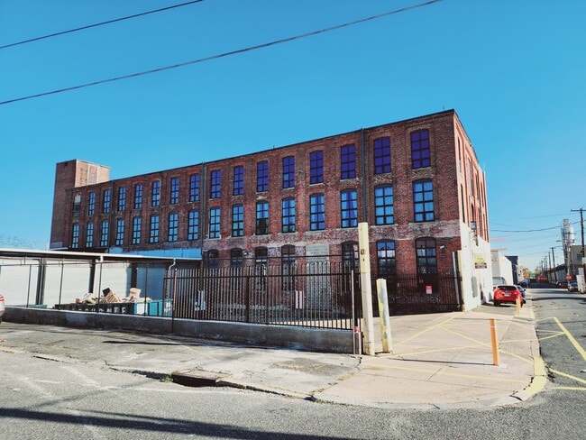
3451 Edgemont St, Philadelphia, PA 19134


Current Lease Availabilities
NEARBY LISTINGS FOR SALE OR LEASE
Property Detail
3451 Edgemont St
884199700
NEC SCHILLER TO SEC
Industrialgeneral
Philadelphia
X
Pennsylvania
34007C0026F
10
2024
1.69 AC
2026
Kensington
017800
Philadelphia
100,126 SF
Philadelphia-Camden-Wilmington, PA-NJ-DE-MD
DEMOGRAPHICS near 3451 Edgemont St
1 Mile
3 Mile
5 Mile
2024 Total Population
26,013
276,732
886,085
2029 Population
25,121
269,948
864,897
Pop Growth 2024-2029
(3.43%)
(2.45%)
(2.39%)
Average Age
37
36
37
2024 Total Households
10,152
101,969
351,748
HH Growth 2024-2029
(3.65%)
(2.54%)
(2.52%)
Median Household Inc
$47,318
$42,761
$52,535
Avg Household Size
2.50
2.60
2.40
2024 Avg HH Vehicles
1.00
1.00
1.00
Median Home Value
$175,347
$166,606
$191,244
Median Year Built
1946
1947
1949
Nearby Places
Map Layers
Map Styles
 Street
 Aerial
- Restaurants
- Banks
- Shops
- Fitness
- Groceries
PUBLIC TRANSPORTATION
TRANSIT/SUBWAY
Richmond And Westmoreland (Route 15 - Southeastern Pennsylvania Transportation Authority Rapid Transit (SEPTA Subway & Trolley))
DRIVE
WALK
Distance
Richmond And Westmoreland (Route 15 - Southeastern Pennsylvania Transportation Authority Rapid Transit (SEPTA Subway & Trolley))
2 min
7 min
0.4 mi
Richmond St & Allegheny Av (63rd-Girard to Richmond-Westmorelnd - SEPTA)
DRIVE
WALK
Distance
Richmond St & Allegheny Av (63rd-Girard to Richmond-Westmorelnd - SEPTA)
1 min
10 min
0.5 mi
Richmond St & Clearfield St (63rd-Girard to Richmond-Westmorelnd - SEPTA)
DRIVE
WALK
Distance
Richmond St & Clearfield St (63rd-Girard to Richmond-Westmorelnd - SEPTA)
2 min
13 min
0.7 mi
Richmond St & Ann St (63rd-Girard to Richmond-Westmorelnd - SEPTA)
DRIVE
WALK
Distance
Richmond St & Ann St (63rd-Girard to Richmond-Westmorelnd - SEPTA)
3 min
17 min
0.9 mi
Richmond St & Cambria St (63rd-Girard to Richmond-Westmorelnd - SEPTA)
DRIVE
WALK
Distance
Richmond St & Cambria St (63rd-Girard to Richmond-Westmorelnd - SEPTA)
6 min
19 min
1.0 mi
COMMUTER RAIL
Bridesburg (R7 - Southeastern Pennsylvania Transportation Authority Regional Rail (SEPTA Regional Rail))
DRIVE
WALK
Distance
Bridesburg (R7 - Southeastern Pennsylvania Transportation Authority Regional Rail (SEPTA Regional Rail))
6 min
2.9 mi
Pennsauken Transit Center (Atlantic City Rail Line - NJ TRANSIT RAIL)
DRIVE
WALK
Distance
Pennsauken Transit Center (Atlantic City Rail Line - NJ TRANSIT RAIL)
13 min
6.7 mi
AIRPORT
Philadelphia International
DRIVE
WALK
Distance
Philadelphia International
25 min
15.0 mi
Trenton Mercer
DRIVE
WALK
Distance
Trenton Mercer
43 min
29.3 mi
Freight Ports
Port of Philadelphia
DRIVE
WALK
Distance
Port of Philadelphia
3 min
0.9 mi
Nearby Properties
Address
Land Use
TOTAL SIZE
Lot Size
Zoning
Address
Land Use
TOTAL SIZE
Lot Size
Zoning
880,950 SF
27.71 AC
SPENT
Address
Land Use
TOTAL SIZE
Lot Size
Zoning
804,000 SF
4.29 AC
CMX3
Address
Land Use
TOTAL SIZE
Lot Size
Zoning
322,000 SF
7.44 AC
CMX3
Address
Land Use
TOTAL SIZE
Lot Size
Zoning
740,701 SF
47.70 AC
I2
Address
Land Use
TOTAL SIZE
Lot Size
Zoning
458,556 SF
1.57 AC
CMX3
Address
Land Use
TOTAL SIZE
Lot Size
Zoning
8.50 AC
Address
Land Use
TOTAL SIZE
Lot Size
Zoning
390,773 SF
2.86 AC
CMX3
Address
Land Use
TOTAL SIZE
Lot Size
Zoning
458,556 SF
1.39 AC
CMX3
Address
Land Use
TOTAL SIZE
Lot Size
Zoning
470,871 SF
41.87 AC
I3
Address
Land Use
TOTAL SIZE
Lot Size
Zoning
163,400 SF
1.20 AC
CMX3
Address
Land Use
TOTAL SIZE
Lot Size
Zoning
265,000 SF
1.83 AC
CMX3
Address
Land Use
TOTAL SIZE
Lot Size
Zoning
561,600 SF
11.28 AC
CMX3
Address
Land Use
TOTAL SIZE
Lot Size
Zoning
184,842 SF
0.76 AC
CMX3
Address
Land Use
TOTAL SIZE
Lot Size
Zoning
75,358 SF
24.98 AC
I2
Address
Land Use
TOTAL SIZE
Lot Size
Zoning
172,844 SF
1.04 AC
CMX2.5
Address
Land Use
TOTAL SIZE
Lot Size
Zoning
1,316,610 SF
46.73 AC
I2
Address
Land Use
TOTAL SIZE
Lot Size
Zoning
208,620 SF
19.71 AC
I2
Address
Land Use
TOTAL SIZE
Lot Size
Zoning
404,025 SF
1.21 AC
RM4
Address
Land Use
TOTAL SIZE
Lot Size
Zoning
227,844 SF
19.82 AC
I2
Address
Land Use
TOTAL SIZE
Lot Size
Zoning
123,750 SF
0.54 AC
CMX2.5
Address
Land Use
TOTAL SIZE
Lot Size
Zoning
190,276 SF
0.52 AC
CMX3
Address
Land Use
TOTAL SIZE
Lot Size
Zoning
5.37 AC
I2
Address
Land Use
TOTAL SIZE
Lot Size
Zoning
251,657 SF
0.99 AC
ICMX
Address
Land Use
TOTAL SIZE
Lot Size
Zoning
253,800 SF
0.61 AC
RM1
Address
Land Use
TOTAL SIZE
Lot Size
Zoning
1,488 SF
0.02 AC
ICMX
Address
Land Use
TOTAL SIZE
Lot Size
Zoning
Address
Land Use
TOTAL SIZE
Lot Size
Zoning
105,994 SF
0.74 AC
CMX3
Address
Land Use
TOTAL SIZE
Lot Size
Zoning
217,800 SF
0.31 AC
ICMX
Address
Land Use
TOTAL SIZE
Lot Size
Zoning
5,406 SF
0.76 AC
CMX3
Address
Land Use
TOTAL SIZE
Lot Size
Zoning
9,300 SF
1.30 AC
I3
The World's #1 Commercial Real Estate Marketplace
Connect with us
© 2025 CoStar Group
The information above has been obtained from sources believed reliable. While we do not doubt its accuracy we have not verified it and make no guarantee, warranty or representation about it. It is your responsibility to independently confirm its accuracy and completeness. Any projections, opinions, assumptions, or estimates used are for example only and do not represent the current or future performance of the property. The value of this transaction to you depends on tax and other factors which should be evaluated by your tax, financial, and legal advisors. You and your advisors should conduct a careful, independent investigation of the property to determine to your satisfaction the suitability of the property for your needs.