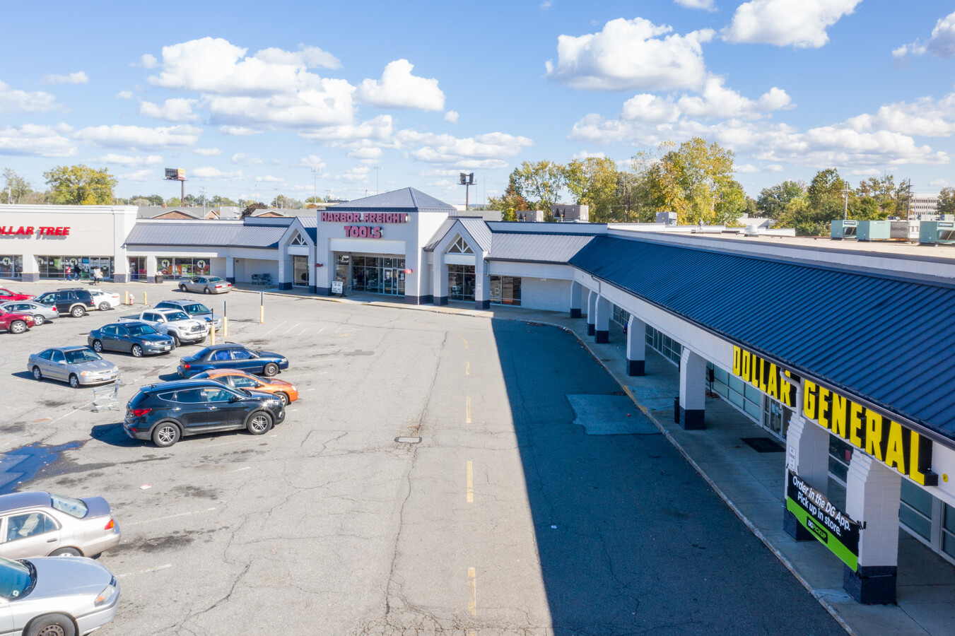
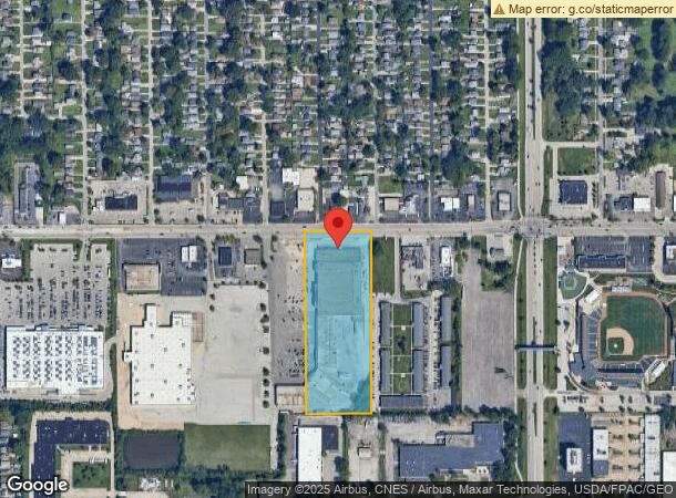
Property Record
34714 Vine St, Willowick, OH 44095


NEARBY LISTINGS FOR SALE OR LEASE
Property Detail
34714 Vine St
Cleveland-Elyria, OH
Card
34-A-007-0-00-028
LOT 10 CARD TRACT & LOT 5 TRACT 14
Regionalshoppingcenterormallwithanchorstore
Lake
X
Ohio
39085C0089G
10,5
2024
8 AC
2023
Northeast
202100
Cleveland
145,899 SF
DEMOGRAPHICS near 34714 Vine St
1 Mile
3 Mile
5 Mile
2024 Total Population
8,899
59,889
119,684
2029 Population
8,853
59,753
119,374
Pop Growth 2024-2029
(0.52%)
(0.23%)
(0.26%)
Average Age
42
44
43
2024 Total Households
4,037
27,914
55,641
HH Growth 2024-2029
(0.52%)
(0.18%)
(0.25%)
Median Household Inc
$62,473
$67,981
$60,362
Avg Household Size
2.20
2.10
2.10
2024 Avg HH Vehicles
2.00
2.00
2.00
Median Home Value
$142,846
$158,607
$160,417
Median Year Built
1958
1962
1964
Nearby Places
- Restaurants
- Banks
- Shops
- Fitness
- Groceries
PUBLIC TRANSPORTATION
AIRPORT
Cleveland-Hopkins International
DRIVE
WALK
Distance
Cleveland-Hopkins International
44 min
30.7 mi
Freight Ports
Port of Toledo
DRIVE
WALK
Distance
Port of Toledo
158 min
131.1 mi
SALE & LEASE HISTORY
LISTING DATE
SALE/LEASE

Sep 26, 2016
For Lease
Sep 25, 2016
For Lease
Oct 29, 2020
For Sale
Oct 17, 2022
For Lease
Jan 31, 2018
For Lease
Apr 19, 2017
For Lease
Nearby Properties
Address
Land Use
TOTAL SIZE
Lot Size
Zoning
Address
Land Use
TOTAL SIZE
Lot Size
Zoning
120.34 AC
Address
Land Use
TOTAL SIZE
Lot Size
Zoning
488,790 SF
11.54 AC
R-MFL
Address
Land Use
TOTAL SIZE
Lot Size
Zoning
327,593 SF
103.27 AC
Address
Land Use
TOTAL SIZE
Lot Size
Zoning
307,867 SF
31.16 AC
S-CMF
Address
Land Use
TOTAL SIZE
Lot Size
Zoning
241,441 SF
17.18 AC
I
Address
Land Use
TOTAL SIZE
Lot Size
Zoning
308,298 SF
15.93 AC
Address
Land Use
TOTAL SIZE
Lot Size
Zoning
45,768 SF
13.53 AC
Address
Land Use
TOTAL SIZE
Lot Size
Zoning
120,352 SF
15.05 AC
1FM60
Address
Land Use
TOTAL SIZE
Lot Size
Zoning
416,506 SF
28.90 AC
Address
Land Use
TOTAL SIZE
Lot Size
Zoning
75,843 SF
10.23 AC
B
Address
Land Use
TOTAL SIZE
Lot Size
Zoning
214,881 SF
47.98 AC
S-5
Address
Land Use
TOTAL SIZE
Lot Size
Zoning
53,637 SF
13.44 AC
G-BUS
Address
Land Use
TOTAL SIZE
Lot Size
Zoning
272,400 SF
1.07 AC
U2D
Address
Land Use
TOTAL SIZE
Lot Size
Zoning
65,102 SF
8.80 AC
M
Address
Land Use
TOTAL SIZE
Lot Size
Zoning
226,141 SF
6.50 AC
M
Address
Land Use
TOTAL SIZE
Lot Size
Zoning
81,965 SF
10.65 AC
R
Address
Land Use
TOTAL SIZE
Lot Size
Zoning
64,113 SF
5.74 AC
M
Address
Land Use
TOTAL SIZE
Lot Size
Zoning
174,098 SF
20.51 AC
U-1
Address
Land Use
TOTAL SIZE
Lot Size
Zoning
187,332 SF
10 AC
R-100
Address
Land Use
TOTAL SIZE
Lot Size
Zoning
136,722 SF
10.25 AC
GB
Address
Land Use
TOTAL SIZE
Lot Size
Zoning
164,666 SF
8 AC
R-100
Address
Land Use
TOTAL SIZE
Lot Size
Zoning
159,188 SF
12.43 AC
R-BUS
Address
Land Use
TOTAL SIZE
Lot Size
Zoning
427,687 SF
6.15 AC
I
Address
Land Use
TOTAL SIZE
Lot Size
Zoning
133,526 SF
4 AC
Address
Land Use
TOTAL SIZE
Lot Size
Zoning
124,170 SF
35.77 AC
1FM60
Address
Land Use
TOTAL SIZE
Lot Size
Zoning
120,676 SF
9.07 AC
R-MFL
Address
Land Use
TOTAL SIZE
Lot Size
Zoning
70,325 SF
9.16 AC
Address
Land Use
TOTAL SIZE
Lot Size
Zoning
122,130 SF
9.51 AC
Address
Land Use
TOTAL SIZE
Lot Size
Zoning
142,504 SF
15.41 AC
R-MFL
Address
Land Use
TOTAL SIZE
Lot Size
Zoning
109,803 SF
9.77 AC
The World's #1 Commercial Real Estate Marketplace
Connect with us
© 2025 CoStar Group
The information above has been obtained from sources believed reliable. While we do not doubt its accuracy we have not verified it and make no guarantee, warranty or representation about it. It is your responsibility to independently confirm its accuracy and completeness. Any projections, opinions, assumptions, or estimates used are for example only and do not represent the current or future performance of the property. The value of this transaction to you depends on tax and other factors which should be evaluated by your tax, financial, and legal advisors. You and your advisors should conduct a careful, independent investigation of the property to determine to your satisfaction the suitability of the property for your needs.