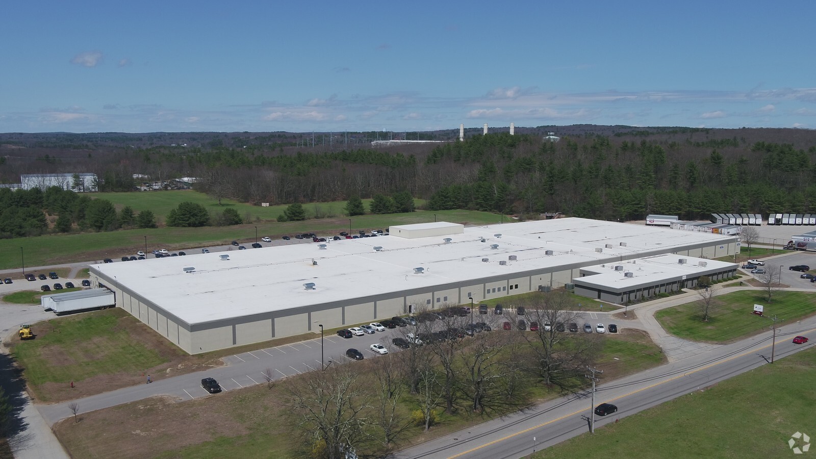
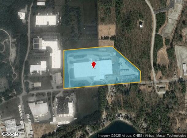
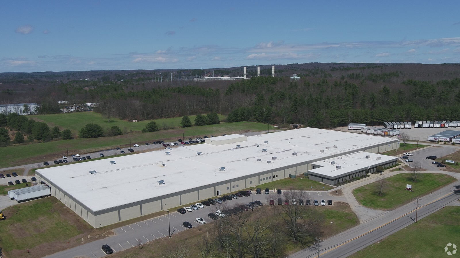
Property Record
349 Lake Rd, Dayville, CT 06241
NEARBY LISTINGS FOR SALE OR LEASE
Property Detail
349 Lake Rd
KILL-000061-000000-000007
Windham
Manufacturinglight
Connecticut
2024
20.74 AC
2024
Windham County
904400
Hartford
219,244 SF
Worcester, MA-CT
DEMOGRAPHICS near 349 Lake Rd
1 Mile
3 Mile
5 Mile
2024 Total Population
647
7,535
29,318
2029 Population
648
7,452
29,285
Pop Growth 2024-2029
+ 0.15%
(1.10%)
(0.11%)
Average Age
43
41
42
2024 Total Households
268
2,960
12,080
HH Growth 2024-2029
+ 0.37%
(1.08%)
(0.04%)
Median Household Inc
$73,071
$79,185
$72,345
Avg Household Size
2.30
2.40
2.30
2024 Avg HH Vehicles
2.00
2.00
2.00
Median Home Value
$328,161
$273,934
$234,390
Median Year Built
1952
1970
1964
Nearby Places
- Restaurants
- Banks
- Shops
- Fitness
- Groceries
PUBLIC TRANSPORTATION
AIRPORT
Worcester Regional
DRIVE
WALK
Distance
Worcester Regional
46 min
32.2 mi
Rhode Island Tf Green International
DRIVE
WALK
Distance
Rhode Island Tf Green International
50 min
37.3 mi
Freight Ports
Port of Davisville, RI
DRIVE
WALK
Distance
Port of Davisville, RI
61 min
46.5 mi
SALE & LEASE HISTORY
LISTING DATE
SALE/LEASE

Jan 20, 2017
For Lease
Apr 10, 2017
For Lease
Nearby Properties
Address
Land Use
TOTAL SIZE
Lot Size
Zoning
Address
Land Use
TOTAL SIZE
Lot Size
Zoning
141.59 AC
RD
Address
Land Use
TOTAL SIZE
Lot Size
Zoning
13.76 AC
Address
Land Use
TOTAL SIZE
Lot Size
Zoning
86 AC
LD
Address
Land Use
TOTAL SIZE
Lot Size
Zoning
Address
Land Use
TOTAL SIZE
Lot Size
Zoning
47 AC
MUI
Address
Land Use
TOTAL SIZE
Lot Size
Zoning
460,362 SF
32.08 AC
I
Address
Land Use
TOTAL SIZE
Lot Size
Zoning
139,490 SF
16.75 AC
MUI
Address
Land Use
TOTAL SIZE
Lot Size
Zoning
307,955 SF
52 AC
I
Address
Land Use
TOTAL SIZE
Lot Size
Zoning
29.78 AC
I
Address
Land Use
TOTAL SIZE
Lot Size
Zoning
169.79 AC
ALZ.L
Address
Land Use
TOTAL SIZE
Lot Size
Zoning
126,601 SF
13.40 AC
MUI
Address
Land Use
TOTAL SIZE
Lot Size
Zoning
62 AC
LD
Address
Land Use
TOTAL SIZE
Lot Size
Zoning
864 SF
50 AC
VC/LD
Address
Land Use
TOTAL SIZE
Lot Size
Zoning
6.61 AC
MUI
Address
Land Use
TOTAL SIZE
Lot Size
Zoning
20,644 SF
80.30 AC
Address
Land Use
TOTAL SIZE
Lot Size
Zoning
7.07 AC
GC
Address
Land Use
TOTAL SIZE
Lot Size
Zoning
30,036 SF
5.82 AC
RD
Address
Land Use
TOTAL SIZE
Lot Size
Zoning
9.09 AC
I
Address
Land Use
TOTAL SIZE
Lot Size
Zoning
112,693 SF
6.71 AC
LD
Address
Land Use
TOTAL SIZE
Lot Size
Zoning
10.50 AC
GC
Address
Land Use
TOTAL SIZE
Lot Size
Zoning
40,240 SF
1.84 AC
GC
Address
Land Use
TOTAL SIZE
Lot Size
Zoning
131,792 SF
18.69 AC
Address
Land Use
TOTAL SIZE
Lot Size
Zoning
85,301 SF
47.97 AC
I
Address
Land Use
TOTAL SIZE
Lot Size
Zoning
12,982 SF
1.54 AC
GC
Address
Land Use
TOTAL SIZE
Lot Size
Zoning
48,032 SF
9.40 AC
LD
Address
Land Use
TOTAL SIZE
Lot Size
Zoning
49,445 SF
8.57 AC
Address
Land Use
TOTAL SIZE
Lot Size
Zoning
15 AC
I
Address
Land Use
TOTAL SIZE
Lot Size
Zoning
74,072 SF
8 AC
I
Address
Land Use
TOTAL SIZE
Lot Size
Zoning
173,650 SF
26.63 AC
The World's #1 Commercial Real Estate Marketplace
Connect with us
© 2025 CoStar Group
The information above has been obtained from sources believed reliable. While we do not doubt its accuracy we have not verified it and make no guarantee, warranty or representation about it. It is your responsibility to independently confirm its accuracy and completeness. Any projections, opinions, assumptions, or estimates used are for example only and do not represent the current or future performance of the property. The value of this transaction to you depends on tax and other factors which should be evaluated by your tax, financial, and legal advisors. You and your advisors should conduct a careful, independent investigation of the property to determine to your satisfaction the suitability of the property for your needs.