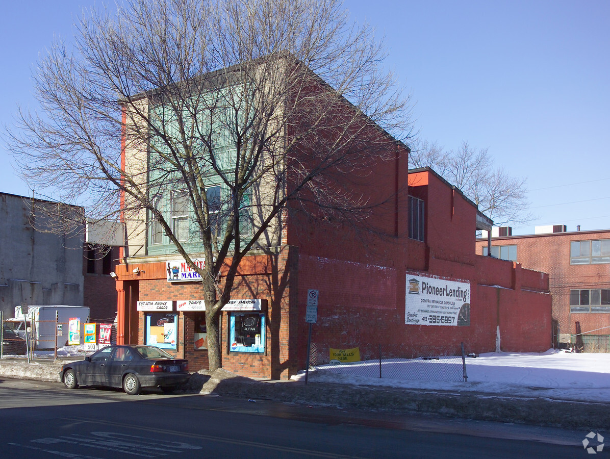
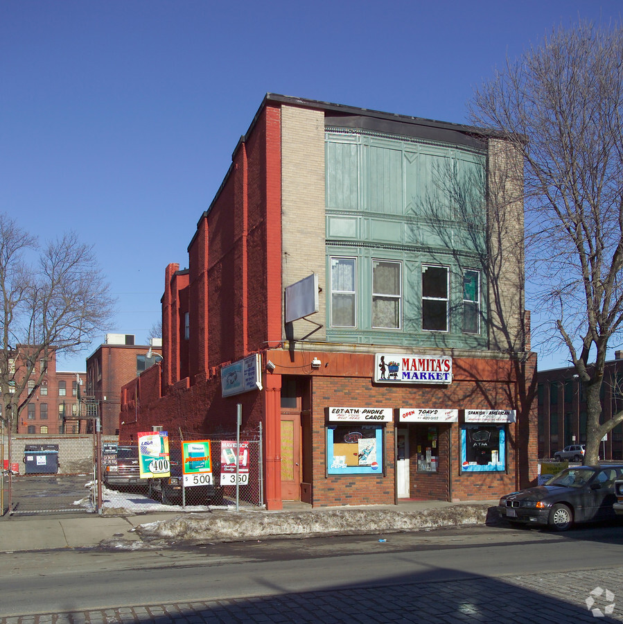
Property Record
349 Main St, Holyoke, MA 01040
NEARBY LISTINGS FOR SALE OR LEASE
Property Detail
349 Main St
HOLY-000028-000006-000004
Hampden
Commercialofficeresidentialmixeduse
Massachusetts
X
4
25013C0203E
0.05 AC
0
Hampden County
2024
Hartford
811500
Springfield, MA
4,620 SF
DEMOGRAPHICS near 349 Main St
1 Mile
3 Mile
5 Mile
2024 Total Population
19,712
78,062
132,075
2029 Population
19,573
75,221
125,715
Pop Growth 2024-2029
(0.71%)
(3.64%)
(4.82%)
Average Age
36
41
41
2024 Total Households
7,876
33,073
54,989
HH Growth 2024-2029
(0.72%)
(3.90%)
(5.07%)
Median Household Inc
$27,122
$52,561
$58,329
Avg Household Size
2.40
2.30
2.30
2024 Avg HH Vehicles
1.00
1.00
2.00
Median Home Value
$195,532
$241,176
$247,978
Median Year Built
1948
1955
1956
Nearby Places
- Restaurants
- Banks
- Shops
- Fitness
- Groceries
PUBLIC TRANSPORTATION
COMMUTER RAIL
Holyoke Amtrak (Valley Flyer - Amtrak, Vermonter - Amtrak)
DRIVE
WALK
Distance
Holyoke Amtrak (Valley Flyer - Amtrak, Vermonter - Amtrak)
1 min
8 min
0.4 mi
Springfield (Amtrak Hartford Line - Hartford Line, Hartford Line - Hartford Line, Lake Shore Limited - Hartford Line, Northeast Regional - Hartford Line, Valley Flyer - Hartford Line, Vermonter - Hartford Line)
DRIVE
WALK
Distance
Springfield (Amtrak Hartford Line - Hartford Line, Hartford Line - Hartford Line, Lake Shore Limited - Hartford Line, Northeast Regional - Hartford Line, Valley Flyer - Hartford Line, Vermonter - Hartford Line)
11 min
7.6 mi
AIRPORT
Bradley International
DRIVE
WALK
Distance
Bradley International
41 min
20.2 mi
Freight Ports
Port of New Haven
DRIVE
WALK
Distance
Port of New Haven
92 min
71.9 mi
Nearby Properties
Address
Land Use
TOTAL SIZE
Lot Size
Zoning
Address
Land Use
TOTAL SIZE
Lot Size
Zoning
50.96 AC
BH
Address
Land Use
TOTAL SIZE
Lot Size
Zoning
22.15 AC
R-1A
Address
Land Use
TOTAL SIZE
Lot Size
Zoning
21.80 AC
106
Address
Land Use
TOTAL SIZE
Lot Size
Zoning
29.88 AC
105
Address
Land Use
TOTAL SIZE
Lot Size
Zoning
22.77 AC
111A
Address
Land Use
TOTAL SIZE
Lot Size
Zoning
171,241 SF
18.94 AC
106
Address
Land Use
TOTAL SIZE
Lot Size
Zoning
189,022 SF
10.62 AC
RA
Address
Land Use
TOTAL SIZE
Lot Size
Zoning
17.72 AC
R-2
Address
Land Use
TOTAL SIZE
Lot Size
Zoning
30.45 AC
106
Address
Land Use
TOTAL SIZE
Lot Size
Zoning
223,390 SF
13.83 AC
111A
Address
Land Use
TOTAL SIZE
Lot Size
Zoning
26.68 AC
110
Address
Land Use
TOTAL SIZE
Lot Size
Zoning
17.64 AC
105
Address
Land Use
TOTAL SIZE
Lot Size
Zoning
4.04 AC
107
Address
Land Use
TOTAL SIZE
Lot Size
Zoning
257,179 SF
22.84 AC
110
Address
Land Use
TOTAL SIZE
Lot Size
Zoning
12.90 AC
IP
Address
Land Use
TOTAL SIZE
Lot Size
Zoning
136,654 SF
11.71 AC
BG
Address
Land Use
TOTAL SIZE
Lot Size
Zoning
8.16 AC
RM40
Address
Land Use
TOTAL SIZE
Lot Size
Zoning
16.38 AC
RA
Address
Land Use
TOTAL SIZE
Lot Size
Zoning
320,639 SF
14.16 AC
110
Address
Land Use
TOTAL SIZE
Lot Size
Zoning
2.41 AC
DR
Address
Land Use
TOTAL SIZE
Lot Size
Zoning
23,111 SF
1.43 AC
IA
Address
Land Use
TOTAL SIZE
Lot Size
Zoning
201,953 SF
5.64 AC
BH
Address
Land Use
TOTAL SIZE
Lot Size
Zoning
4.66 AC
105
Address
Land Use
TOTAL SIZE
Lot Size
Zoning
138,289 SF
22.79 AC
IG
Address
Land Use
TOTAL SIZE
Lot Size
Zoning
196,705 SF
21.45 AC
RM20
Address
Land Use
TOTAL SIZE
Lot Size
Zoning
30 AC
104
Address
Land Use
TOTAL SIZE
Lot Size
Zoning
135,552 SF
13.18 AC
RO
Address
Land Use
TOTAL SIZE
Lot Size
Zoning
26.98 AC
BG
Address
Land Use
TOTAL SIZE
Lot Size
Zoning
19.80 AC
105
Address
Land Use
TOTAL SIZE
Lot Size
Zoning
201,410 SF
13.16 AC
RM20
The World's #1 Commercial Real Estate Marketplace
Connect with us
© 2025 CoStar Group
The information above has been obtained from sources believed reliable. While we do not doubt its accuracy we have not verified it and make no guarantee, warranty or representation about it. It is your responsibility to independently confirm its accuracy and completeness. Any projections, opinions, assumptions, or estimates used are for example only and do not represent the current or future performance of the property. The value of this transaction to you depends on tax and other factors which should be evaluated by your tax, financial, and legal advisors. You and your advisors should conduct a careful, independent investigation of the property to determine to your satisfaction the suitability of the property for your needs.