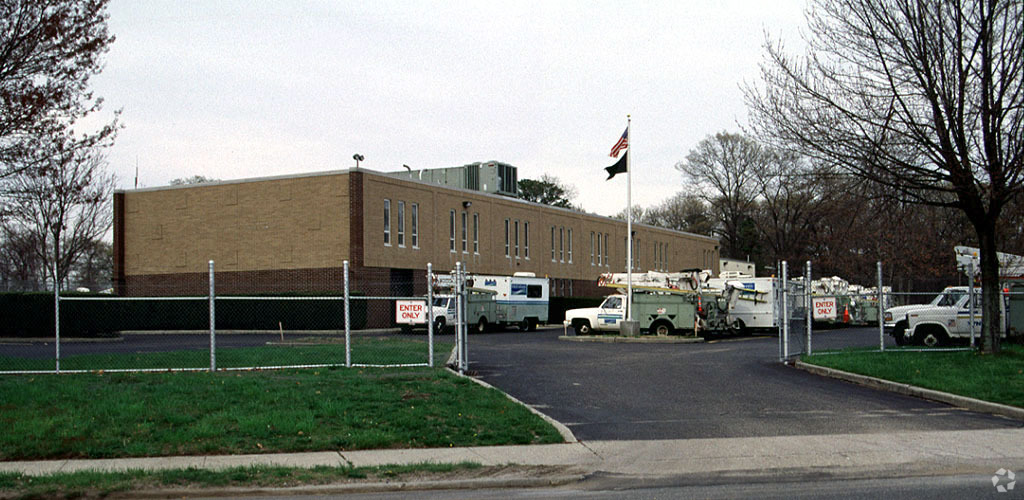
Property Record
35 Horseblock Rd, Centereach, NY 11720

NEARBY LISTINGS FOR SALE OR LEASE
-
-
View all Centereach listings for sale on LoopNet.com
Property Detail
35 Horseblock Rd
Nassau County-Suffolk County, NY
Tredwell Daniel P
0200-516-00-07-00-010-000
D P TREADWELL 6 492 S E 205X434 OF
Telephonefacility
Suffolk
X
New York
36103C0680H
10
2023
2.67 AC
2023
North Central Suffolk
158119
Long Island (New York)
DEMOGRAPHICS near 35 Horseblock Rd
1 Mile
3 Mile
5 Mile
2024 Total Population
9,371
99,782
246,194
2029 Population
9,170
97,852
242,370
Pop Growth 2024-2029
(2.14%)
(1.93%)
(1.55%)
Average Age
40
41
41
2024 Total Households
2,864
32,572
81,341
HH Growth 2024-2029
(2.41%)
(2.16%)
(1.78%)
Median Household Inc
$119,392
$114,778
$115,110
Avg Household Size
3.10
3.00
2.80
2024 Avg HH Vehicles
2.00
2.00
2.00
Median Home Value
$433,226
$436,741
$450,072
Median Year Built
1968
1969
1972
Nearby Places
- Restaurants
- Banks
- Shops
- Fitness
- Groceries
PUBLIC TRANSPORTATION
COMMUTER RAIL
Ronkonkoma Station (Greenport Branch - Long Island Rail Road, Ronkonkoma Branch - Long Island Rail Road)
DRIVE
WALK
Distance
Ronkonkoma Station (Greenport Branch - Long Island Rail Road, Ronkonkoma Branch - Long Island Rail Road)
13 min
6.5 mi
Medford Station (Greenport Branch - Long Island Rail Road)
DRIVE
WALK
Distance
Medford Station (Greenport Branch - Long Island Rail Road)
12 min
6.7 mi
AIRPORT
Long Island MacArthur
DRIVE
WALK
Distance
Long Island MacArthur
17 min
10.0 mi
Tweed/New Haven
DRIVE
WALK
Distance
Tweed/New Haven
128 min
48.0 mi
Freight Ports
Port of New Haven
DRIVE
WALK
Distance
Port of New Haven
123 min
45.2 mi
Nearby Properties
Address
Land Use
TOTAL SIZE
Lot Size
Zoning
Address
Land Use
TOTAL SIZE
Lot Size
Zoning
95.19 AC
Address
Land Use
TOTAL SIZE
Lot Size
Zoning
25.90 AC
Address
Land Use
TOTAL SIZE
Lot Size
Zoning
140.10 AC
Address
Land Use
TOTAL SIZE
Lot Size
Zoning
Address
Land Use
TOTAL SIZE
Lot Size
Zoning
16.30 AC
Address
Land Use
TOTAL SIZE
Lot Size
Zoning
Address
Land Use
TOTAL SIZE
Lot Size
Zoning
2,515 SF
0.13 AC
B1
Address
Land Use
TOTAL SIZE
Lot Size
Zoning
44.94 AC
Address
Land Use
TOTAL SIZE
Lot Size
Zoning
31.33 AC
Address
Land Use
TOTAL SIZE
Lot Size
Zoning
21.04 AC
Address
Land Use
TOTAL SIZE
Lot Size
Zoning
Address
Land Use
TOTAL SIZE
Lot Size
Zoning
Address
Land Use
TOTAL SIZE
Lot Size
Zoning
Address
Land Use
TOTAL SIZE
Lot Size
Zoning
27.38 AC
Address
Land Use
TOTAL SIZE
Lot Size
Zoning
34.53 AC
Address
Land Use
TOTAL SIZE
Lot Size
Zoning
42.27 AC
Address
Land Use
TOTAL SIZE
Lot Size
Zoning
Address
Land Use
TOTAL SIZE
Lot Size
Zoning
49.83 AC
Address
Land Use
TOTAL SIZE
Lot Size
Zoning
0.63 AC
R20
Address
Land Use
TOTAL SIZE
Lot Size
Zoning
0.61 AC
R20
Address
Land Use
TOTAL SIZE
Lot Size
Zoning
0.47 AC
R20
Address
Land Use
TOTAL SIZE
Lot Size
Zoning
0.42 AC
R20
Address
Land Use
TOTAL SIZE
Lot Size
Zoning
0.40 AC
R20
Address
Land Use
TOTAL SIZE
Lot Size
Zoning
0.63 AC
R20
Address
Land Use
TOTAL SIZE
Lot Size
Zoning
0.42 AC
R20
Address
Land Use
TOTAL SIZE
Lot Size
Zoning
0.37 AC
R20
Address
Land Use
TOTAL SIZE
Lot Size
Zoning
0.53 AC
R20
Address
Land Use
TOTAL SIZE
Lot Size
Zoning
0.41 AC
R20
Address
Land Use
TOTAL SIZE
Lot Size
Zoning
0.36 AC
R20
Address
Land Use
TOTAL SIZE
Lot Size
Zoning
18.57 AC
The World's #1 Commercial Real Estate Marketplace
Connect with us
© 2025 CoStar Group
The information above has been obtained from sources believed reliable. While we do not doubt its accuracy we have not verified it and make no guarantee, warranty or representation about it. It is your responsibility to independently confirm its accuracy and completeness. Any projections, opinions, assumptions, or estimates used are for example only and do not represent the current or future performance of the property. The value of this transaction to you depends on tax and other factors which should be evaluated by your tax, financial, and legal advisors. You and your advisors should conduct a careful, independent investigation of the property to determine to your satisfaction the suitability of the property for your needs.