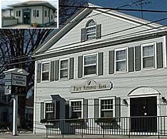
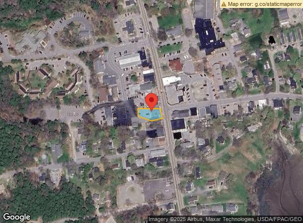
Property Record
350 Main St, Southwest Harbor, ME 04679
NEARBY LISTINGS FOR SALE OR LEASE
-
-
View all Southwest Harbor listings for sale on LoopNet.com
Property Detail
350 Main St
Financialbuilding
Hancock
X
Maine
23009C1214D
30
2024
0.16 AC
2024
Other Market Areas
966100
SOUR-000006-000000-000030
DEMOGRAPHICS near 350 Main St
1 Mile
3 Mile
5 Mile
2024 Total Population
774
1,905
3,246
2029 Population
758
1,891
3,238
Pop Growth 2024-2029
(2.07%)
(0.73%)
(0.25%)
Average Age
47
47
47
2024 Total Households
375
900
1,519
HH Growth 2024-2029
(2.40%)
(0.89%)
(0.33%)
Median Household Inc
$45,179
$55,245
$65,028
Avg Household Size
2.00
2.10
2.10
2024 Avg HH Vehicles
1.00
2.00
2.00
Median Home Value
$395,762
$368,787
$380,395
Median Year Built
1977
1976
1979
Nearby Places
- Restaurants
- Banks
- Shops
- Fitness
- Groceries
Nearby Properties
Address
Land Use
TOTAL SIZE
Lot Size
Zoning
Address
Land Use
TOTAL SIZE
Lot Size
Zoning
1,392 SF
4.60 AC
SR2
Address
Land Use
TOTAL SIZE
Lot Size
Zoning
12,515 SF
19.30 AC
SR3
Address
Land Use
TOTAL SIZE
Lot Size
Zoning
12,289 SF
8.70 AC
SR2
Address
Land Use
TOTAL SIZE
Lot Size
Zoning
6,797 SF
3 AC
SR3
Address
Land Use
TOTAL SIZE
Lot Size
Zoning
270 SF
0.24 AC
C
Address
Land Use
TOTAL SIZE
Lot Size
Zoning
10,991 SF
3.30 AC
SR2
Address
Land Use
TOTAL SIZE
Lot Size
Zoning
8,999 SF
3.66 AC
SR2
Address
Land Use
TOTAL SIZE
Lot Size
Zoning
6,618 SF
6.42 AC
SR2
Address
Land Use
TOTAL SIZE
Lot Size
Zoning
652 AC
C
Address
Land Use
TOTAL SIZE
Lot Size
Zoning
7,202 SF
5 AC
SR2
Address
Land Use
TOTAL SIZE
Lot Size
Zoning
7,093 SF
2.19 AC
SC
Address
Land Use
TOTAL SIZE
Lot Size
Zoning
Address
Land Use
TOTAL SIZE
Lot Size
Zoning
32,170 SF
9 AC
VR1
Address
Land Use
TOTAL SIZE
Lot Size
Zoning
Address
Land Use
TOTAL SIZE
Lot Size
Zoning
5,634 SF
3.50 AC
SR3
Address
Land Use
TOTAL SIZE
Lot Size
Zoning
5,163 SF
5.30 AC
SR2/RP
Address
Land Use
TOTAL SIZE
Lot Size
Zoning
Address
Land Use
TOTAL SIZE
Lot Size
Zoning
6,440 SF
2.50 AC
SR2
Address
Land Use
TOTAL SIZE
Lot Size
Zoning
4,857 SF
1.20 AC
SR2
Address
Land Use
TOTAL SIZE
Lot Size
Zoning
36,114 SF
2.58 AC
VC
Address
Land Use
TOTAL SIZE
Lot Size
Zoning
1,947 SF
2.41 AC
SR2
Address
Land Use
TOTAL SIZE
Lot Size
Zoning
Address
Land Use
TOTAL SIZE
Lot Size
Zoning
4,746 SF
3.34 AC
SR2
Address
Land Use
TOTAL SIZE
Lot Size
Zoning
3,985 SF
0.95 AC
SR2
Address
Land Use
TOTAL SIZE
Lot Size
Zoning
Address
Land Use
TOTAL SIZE
Lot Size
Zoning
5,411 SF
2.82 AC
SR2
Address
Land Use
TOTAL SIZE
Lot Size
Zoning
7,751 SF
2.18 AC
SR1
Address
Land Use
TOTAL SIZE
Lot Size
Zoning
15,129 SF
0.65 AC
VR1
Address
Land Use
TOTAL SIZE
Lot Size
Zoning
2,529 SF
1.20 AC
SR1
Address
Land Use
TOTAL SIZE
Lot Size
Zoning
127.60 AC
The World's #1 Commercial Real Estate Marketplace
Connect with us
© 2025 CoStar Group
The information above has been obtained from sources believed reliable. While we do not doubt its accuracy we have not verified it and make no guarantee, warranty or representation about it. It is your responsibility to independently confirm its accuracy and completeness. Any projections, opinions, assumptions, or estimates used are for example only and do not represent the current or future performance of the property. The value of this transaction to you depends on tax and other factors which should be evaluated by your tax, financial, and legal advisors. You and your advisors should conduct a careful, independent investigation of the property to determine to your satisfaction the suitability of the property for your needs.