Property Record
3500 E Historic Highway 66, Gallup, NM 87301


NEARBY LISTINGS FOR SALE OR LEASE
-
-
View all Gallup listings for sale on LoopNet.com
Property Detail
3500 E Historic Highway 66
Gallup, NM
Indian Hills Sub
2102088202244
LOT 5, EAST TOWN SUB. UNIT 1, REPLAT NO. 1 OF BOYD SUB. UNIT 1 INCLUDING THE UNPLATTED TRACT THAT LIES IN THE SW1/4 OF SEC. 18 T15N R17W & TRACT 2, INDIAN HILLS SUB. UNIT 4, CONT. 1.1147 ACRES M/L BK 22 PG 4911 4/16/04 PLAT DOC 36724505/12/14 DOC 367
Commercialnec
Mckinley
X
New Mexico
35031C1545E
5
2024
1.12 AC
2024
Gallup/Grants
945601
Other Market Areas
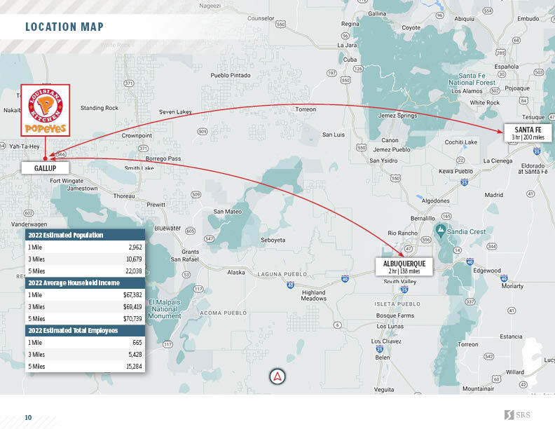
DEMOGRAPHICS near 3500 E Historic Highway 66
1 Mile
3 Mile
5 Mile
2024 Total Population
2,665
11,441
23,506
2029 Population
2,558
10,981
22,571
Pop Growth 2024-2029
(4.02%)
(4.02%)
(3.98%)
Average Age
36
37
37
2024 Total Households
834
3,762
7,994
HH Growth 2024-2029
(3.96%)
(3.80%)
(3.70%)
Median Household Inc
$88,552
$54,483
$52,878
Avg Household Size
3.00
2.90
2.80
2024 Avg HH Vehicles
2.00
2.00
2.00
Median Home Value
$122,340
$105,534
$111,841
Median Year Built
1985
1982
1976
Nearby Places
- Restaurants
- Banks
- Shops
- Fitness
- Groceries
PUBLIC TRANSPORTATION
COMMUTER RAIL
Gallup Amtrak Station (Southwest Chief - Amtrak)
DRIVE
WALK
Distance
Gallup Amtrak Station (Southwest Chief - Amtrak)
6 min
3.6 mi
Freight Ports
Port of San Diego
DRIVE
WALK
Distance
Port of San Diego
725 min
677.0 mi
SALE & LEASE HISTORY
LISTING DATE
SALE/LEASE

Jan 10, 2024
For Sale
Dec 05, 2022
For Sale
Nearby Properties
Address
Land Use
TOTAL SIZE
Lot Size
Zoning
Address
Land Use
TOTAL SIZE
Lot Size
Zoning
Address
Land Use
TOTAL SIZE
Lot Size
Zoning
Address
Land Use
TOTAL SIZE
Lot Size
Zoning
1.43 AC
Address
Land Use
TOTAL SIZE
Lot Size
Zoning
5.57 AC
Address
Land Use
TOTAL SIZE
Lot Size
Zoning
Address
Land Use
TOTAL SIZE
Lot Size
Zoning
Address
Land Use
TOTAL SIZE
Lot Size
Zoning
Address
Land Use
TOTAL SIZE
Lot Size
Zoning
Address
Land Use
TOTAL SIZE
Lot Size
Zoning
Address
Land Use
TOTAL SIZE
Lot Size
Zoning
Address
Land Use
TOTAL SIZE
Lot Size
Zoning
Address
Land Use
TOTAL SIZE
Lot Size
Zoning
Address
Land Use
TOTAL SIZE
Lot Size
Zoning
Address
Land Use
TOTAL SIZE
Lot Size
Zoning
Address
Land Use
TOTAL SIZE
Lot Size
Zoning
Address
Land Use
TOTAL SIZE
Lot Size
Zoning
0.75 AC
Address
Land Use
TOTAL SIZE
Lot Size
Zoning
2.72 AC
Address
Land Use
TOTAL SIZE
Lot Size
Zoning
3.09 AC
Address
Land Use
TOTAL SIZE
Lot Size
Zoning
Address
Land Use
TOTAL SIZE
Lot Size
Zoning
Address
Land Use
TOTAL SIZE
Lot Size
Zoning
Address
Land Use
TOTAL SIZE
Lot Size
Zoning
Address
Land Use
TOTAL SIZE
Lot Size
Zoning
Address
Land Use
TOTAL SIZE
Lot Size
Zoning
Address
Land Use
TOTAL SIZE
Lot Size
Zoning
1.01 AC
Address
Land Use
TOTAL SIZE
Lot Size
Zoning
Address
Land Use
TOTAL SIZE
Lot Size
Zoning
Address
Land Use
TOTAL SIZE
Lot Size
Zoning
Address
Land Use
TOTAL SIZE
Lot Size
Zoning
The World's #1 Commercial Real Estate Marketplace
Connect with us
© 2025 CoStar Group
The information above has been obtained from sources believed reliable. While we do not doubt its accuracy we have not verified it and make no guarantee, warranty or representation about it. It is your responsibility to independently confirm its accuracy and completeness. Any projections, opinions, assumptions, or estimates used are for example only and do not represent the current or future performance of the property. The value of this transaction to you depends on tax and other factors which should be evaluated by your tax, financial, and legal advisors. You and your advisors should conduct a careful, independent investigation of the property to determine to your satisfaction the suitability of the property for your needs.