Property Record
3500 Moores Spring Rd, Westfield, NC 27053
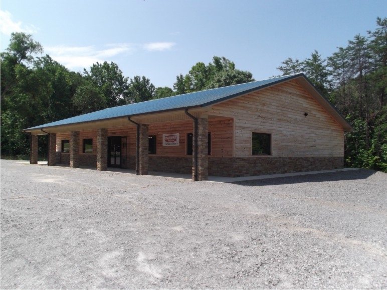
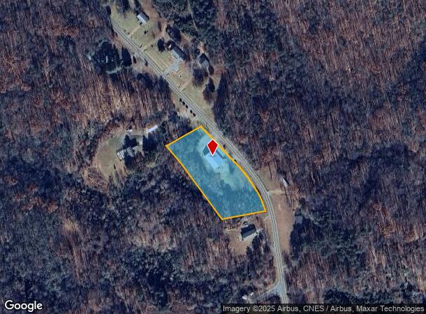
This Property Is For Sale
NEARBY LISTINGS FOR SALE OR LEASE
-
-
View all Westfield listings for sale on LoopNet.com
Property Detail
3500 Moores Spring Rd
692704934022
TR3 PL11-135
Conveniencestore
Stokes
X
North Carolina
3710692700J
1.94 AC
2024
Stokes County
2024
Greensboro/Winston-Salem
070200
Winston-Salem, NC
3,168 SF
DEMOGRAPHICS near 3500 Moores Spring Rd
1 Mile
3 Mile
5 Mile
2024 Total Population
190
1,017
3,959
2029 Population
199
1,068
4,146
Pop Growth 2024-2029
+ 4.74%
+ 5.01%
+ 4.72%
Average Age
46
46
46
2024 Total Households
80
435
1,695
HH Growth 2024-2029
+ 5.00%
+ 5.06%
+ 4.90%
Median Household Inc
$46,718
$46,250
$48,018
Avg Household Size
2.20
2.20
2.20
2024 Avg HH Vehicles
3.00
3.00
3.00
Median Home Value
$166,071
$158,333
$167,336
Median Year Built
1982
1981
1981
Nearby Places
- Restaurants
- Banks
- Shops
- Fitness
- Groceries
PUBLIC TRANSPORTATION
AIRPORT
Piedmont Triad International
DRIVE
WALK
Distance
Piedmont Triad International
65 min
38.7 mi
Freight Ports
Virginia Port Authority - Richmond
DRIVE
WALK
Distance
Virginia Port Authority - Richmond
275 min
210.5 mi
Nearby Properties
Address
Land Use
TOTAL SIZE
Lot Size
Zoning
Address
Land Use
TOTAL SIZE
Lot Size
Zoning
13,885 SF
6,341.36 AC
PARK
Address
Land Use
TOTAL SIZE
Lot Size
Zoning
50,876 SF
79.21 AC
I-1
Address
Land Use
TOTAL SIZE
Lot Size
Zoning
70,433 SF
15.91 AC
I-1
Address
Land Use
TOTAL SIZE
Lot Size
Zoning
20,251 SF
334.98 AC
R-A
Address
Land Use
TOTAL SIZE
Lot Size
Zoning
27,954 SF
0.84 AC
I-1
Address
Land Use
TOTAL SIZE
Lot Size
Zoning
7,888 SF
1.12 AC
B-1
Address
Land Use
TOTAL SIZE
Lot Size
Zoning
9,051 SF
382 AC
R-A
Address
Land Use
TOTAL SIZE
Lot Size
Zoning
412.96 AC
R-A
Address
Land Use
TOTAL SIZE
Lot Size
Zoning
4,979 SF
3.13 AC
B-3
Address
Land Use
TOTAL SIZE
Lot Size
Zoning
4,957 SF
74.35 AC
R-A
Address
Land Use
TOTAL SIZE
Lot Size
Zoning
236.63 AC
R-A
Address
Land Use
TOTAL SIZE
Lot Size
Zoning
7,318 SF
12 AC
R-A
Address
Land Use
TOTAL SIZE
Lot Size
Zoning
166.38 AC
R-A
Address
Land Use
TOTAL SIZE
Lot Size
Zoning
2,185 SF
1.17 AC
R-2
Address
Land Use
TOTAL SIZE
Lot Size
Zoning
95.28 AC
R-A
Address
Land Use
TOTAL SIZE
Lot Size
Zoning
12,774 SF
4.27 AC
I-1
Address
Land Use
TOTAL SIZE
Lot Size
Zoning
90.85 AC
R-A
Address
Land Use
TOTAL SIZE
Lot Size
Zoning
43.61 AC
R-A
Address
Land Use
TOTAL SIZE
Lot Size
Zoning
2,138 SF
5.67 AC
R-3
Address
Land Use
TOTAL SIZE
Lot Size
Zoning
47.99 AC
R-A
Address
Land Use
TOTAL SIZE
Lot Size
Zoning
96.93 AC
R-A
Address
Land Use
TOTAL SIZE
Lot Size
Zoning
3,186 SF
1.90 AC
I-1
Address
Land Use
TOTAL SIZE
Lot Size
Zoning
108.52 AC
R-A
Address
Land Use
TOTAL SIZE
Lot Size
Zoning
4,484 SF
0.86 AC
R-1
Address
Land Use
TOTAL SIZE
Lot Size
Zoning
1,887 SF
I-1
Address
Land Use
TOTAL SIZE
Lot Size
Zoning
75.37 AC
R-A
Address
Land Use
TOTAL SIZE
Lot Size
Zoning
73 AC
R-A
Address
Land Use
TOTAL SIZE
Lot Size
Zoning
50.81 AC
R-3
Address
Land Use
TOTAL SIZE
Lot Size
Zoning
44.51 AC
R-A
The World's #1 Commercial Real Estate Marketplace
Connect with us
© 2025 CoStar Group
The information above has been obtained from sources believed reliable. While we do not doubt its accuracy we have not verified it and make no guarantee, warranty or representation about it. It is your responsibility to independently confirm its accuracy and completeness. Any projections, opinions, assumptions, or estimates used are for example only and do not represent the current or future performance of the property. The value of this transaction to you depends on tax and other factors which should be evaluated by your tax, financial, and legal advisors. You and your advisors should conduct a careful, independent investigation of the property to determine to your satisfaction the suitability of the property for your needs.