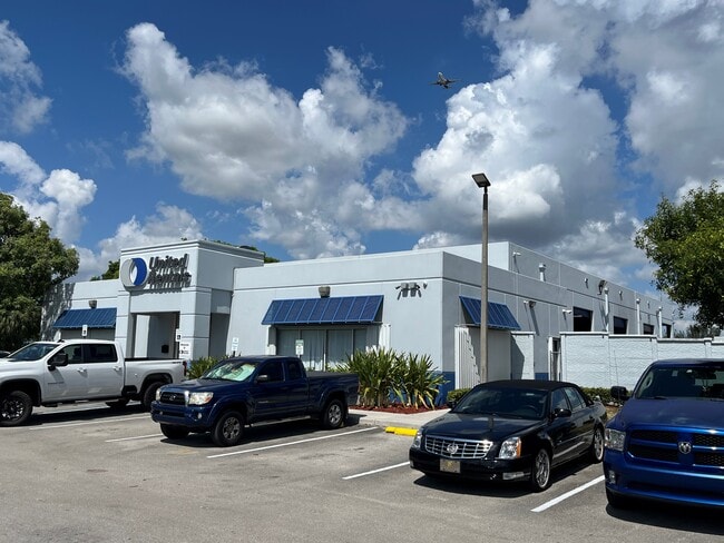
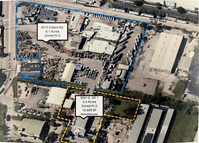
Property Record
3501 S State Road 7, Davie, FL 33314


NEARBY LISTINGS FOR SALE OR LEASE
-
-
-
-
No Photo
-
-
-
-
View all Davie listings for lease on LoopNet.com
Property Detail
3501 S State Road 7
50-41-24-12-0020
Y A F Plat 125-26 B
Warehouse
Y A F PLAT 125-26 B PARCEL B LESS PT DESCD AS,BEG AT NE COR OF PARCEL B,SLY ALG E/L OF PARCEL B FOR 150.00WLY 300.00,NELY 150.00,ELY ALG N/L 300.00 TO POB
AH
Broward
12011C0554J
Florida
2024
3.40 AC
2025
Southeast Broward
070104
South Florida
10,386 SF
Fort Lauderdale-Pompano Beach-Deerfield Beach, FL
DEMOGRAPHICS near 3501 S State Road 7
1 Mile
3 Mile
5 Mile
2024 Total Population
3,966
98,171
351,662
2029 Population
3,912
96,817
349,648
Pop Growth 2024-2029
(1.36%)
(1.38%)
(0.57%)
Average Age
38
38
39
2024 Total Households
1,575
35,081
131,250
HH Growth 2024-2029
(2.03%)
(1.98%)
(0.85%)
Median Household Inc
$58,333
$67,485
$65,296
Avg Household Size
2.50
2.60
2.50
2024 Avg HH Vehicles
2.00
2.00
2.00
Median Home Value
$344,117
$356,275
$349,688
Median Year Built
1980
1974
1974
Nearby Places
Map Layers
Map Styles
 Street
 Aerial
- Restaurants
- Banks
- Shops
- Fitness
- Groceries
PUBLIC TRANSPORTATION
COMMUTER RAIL
Fort Lauderdale/Hollywood International Airport (Mangonia Park - Miami Airport - Tri-Rail, Tri-County Commuter - Tri-Rail, West Palm Beach - MiamiCentral - Tri-Rail)
DRIVE
WALK
Distance
Fort Lauderdale/Hollywood International Airport (Mangonia Park - Miami Airport - Tri-Rail, Tri-County Commuter - Tri-Rail, West Palm Beach - MiamiCentral - Tri-Rail)
9 min
4.1 mi
Fort Lauderdale (Tri-County Commuter - South Florida Regional Transportation Authority (Tri-Rail))
DRIVE
WALK
Distance
Fort Lauderdale (Tri-County Commuter - South Florida Regional Transportation Authority (Tri-Rail))
13 min
5.7 mi
AIRPORT
Fort Lauderdale/Hollywood International
DRIVE
WALK
Distance
Fort Lauderdale/Hollywood International
11 min
5.0 mi
Miami International
DRIVE
WALK
Distance
Miami International
44 min
30.6 mi
Freight Ports
Port Everglades
DRIVE
WALK
Distance
Port Everglades
11 min
6.9 mi
SALE & LEASE HISTORY
LISTING DATE
SALE/LEASE

Jun 03, 2024
For Lease
Nearby Properties
Address
Land Use
TOTAL SIZE
Lot Size
Zoning
Address
Land Use
TOTAL SIZE
Lot Size
Zoning
4,212,940 SF
69.36 AC
N/A
Address
Land Use
TOTAL SIZE
Lot Size
Zoning
4,069,966 SF
161.58 AC
RAC-AV
Address
Land Use
TOTAL SIZE
Lot Size
Zoning
589,748 SF
27.34 AC
RAC-RTE
Address
Land Use
TOTAL SIZE
Lot Size
Zoning
1,357,572 SF
126.23 AC
RAC-ED
Address
Land Use
TOTAL SIZE
Lot Size
Zoning
550,907 SF
26.92 AC
RAC-RTE
Address
Land Use
TOTAL SIZE
Lot Size
Zoning
475,897 SF
14.91 AC
RAC-RTE
Address
Land Use
TOTAL SIZE
Lot Size
Zoning
413,123 SF
63.50 AC
B-3
Address
Land Use
TOTAL SIZE
Lot Size
Zoning
438,123 SF
47.44 AC
RM-22
Address
Land Use
TOTAL SIZE
Lot Size
Zoning
409,340 SF
15.49 AC
RAC-RTE
Address
Land Use
TOTAL SIZE
Lot Size
Zoning
635,706 SF
9.58 AC
GRIFFIN CO
Address
Land Use
TOTAL SIZE
Lot Size
Zoning
456,384 SF
81.33 AC
RAC-ED
Address
Land Use
TOTAL SIZE
Lot Size
Zoning
576,167 SF
27 AC
RAC-RTE
Address
Land Use
TOTAL SIZE
Lot Size
Zoning
334,723 SF
7.47 AC
RAC-AV
Address
Land Use
TOTAL SIZE
Lot Size
Zoning
416,469 SF
2.28 AC
M-PM
Address
Land Use
TOTAL SIZE
Lot Size
Zoning
339,273 SF
20.48 AC
RM-16
Address
Land Use
TOTAL SIZE
Lot Size
Zoning
350,663 SF
16.86 AC
RAC-RTE
Address
Land Use
TOTAL SIZE
Lot Size
Zoning
356,053 SF
8.12 AC
RAC-RTE
Address
Land Use
TOTAL SIZE
Lot Size
Zoning
326,240 SF
45.28 AC
N/A
Address
Land Use
TOTAL SIZE
Lot Size
Zoning
218,137 SF
7.13 AC
RM-2
Address
Land Use
TOTAL SIZE
Lot Size
Zoning
505,730 SF
18.07 AC
RAC-AV
Address
Land Use
TOTAL SIZE
Lot Size
Zoning
161,298 SF
31.25 AC
B-3
Address
Land Use
TOTAL SIZE
Lot Size
Zoning
379,906 SF
39.73 AC
N/A
Address
Land Use
TOTAL SIZE
Lot Size
Zoning
262,844 SF
10.85 AC
B-FCC
Address
Land Use
TOTAL SIZE
Lot Size
Zoning
337,994 SF
3.03 AC
RAC-ND4
Address
Land Use
TOTAL SIZE
Lot Size
Zoning
312,636 SF
24.06 AC
I-G
Address
Land Use
TOTAL SIZE
Lot Size
Zoning
327,948 SF
30.42 AC
CF-P
Address
Land Use
TOTAL SIZE
Lot Size
Zoning
217,019 SF
10.62 AC
B-2
Address
Land Use
TOTAL SIZE
Lot Size
Zoning
247,577 SF
39.47 AC
RAC-ED
Address
Land Use
TOTAL SIZE
Lot Size
Zoning
175,332 SF
4.05 AC
RAC-RTE
Address
Land Use
TOTAL SIZE
Lot Size
Zoning
108,908 SF
19.89 AC
CF-P
The World's #1 Commercial Real Estate Marketplace
Connect with us
© 2025 CoStar Group
The information above has been obtained from sources believed reliable. While we do not doubt its accuracy we have not verified it and make no guarantee, warranty or representation about it. It is your responsibility to independently confirm its accuracy and completeness. Any projections, opinions, assumptions, or estimates used are for example only and do not represent the current or future performance of the property. The value of this transaction to you depends on tax and other factors which should be evaluated by your tax, financial, and legal advisors. You and your advisors should conduct a careful, independent investigation of the property to determine to your satisfaction the suitability of the property for your needs.