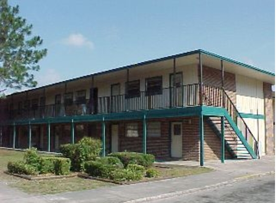
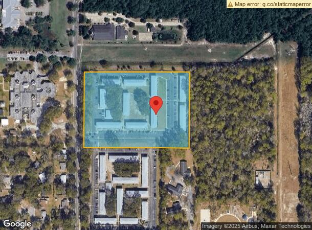
Property Record
3501 Ne 15Th St, Gainesville, FL 32609
NEARBY LISTINGS FOR SALE OR LEASE
Property Detail
3501 Ne 15Th St
08197-002-006
Haile Lt 65 A Condo
Multifamilydwelling
COM NW COR SEC S 1323.32 FT E 50 FT TO E R/W LINE OF SR-329A AND POB CONT E 701 FT SOUTH 503.13 FT W 701 FT TO E R/W N ALONG R/W 501.84 FT POB OR 4780/1083
A
Alachua
12001C0316D
Florida
2023
8.08 AC
2024
Northwest Gainesville
000400
Other Market Areas
82,852 SF
Gainesville, FL
DEMOGRAPHICS near 3501 Ne 15Th St
1 Mile
3 Mile
5 Mile
2024 Total Population
4,613
39,388
102,862
2029 Population
4,859
41,738
108,136
Pop Growth 2024-2029
+ 5.33%
+ 5.97%
+ 5.13%
Average Age
36
37
35
2024 Total Households
1,824
16,864
40,350
HH Growth 2024-2029
+ 5.43%
+ 5.85%
+ 5.45%
Median Household Inc
$42,697
$39,051
$43,398
Avg Household Size
2.50
2.20
2.20
2024 Avg HH Vehicles
1.00
1.00
2.00
Median Home Value
$124,401
$161,014
$186,453
Median Year Built
1973
1974
1977
Nearby Places
- Restaurants
- Banks
- Shops
- Fitness
- Groceries
PUBLIC TRANSPORTATION
AIRPORT
Gainesville Regional
DRIVE
WALK
Distance
Gainesville Regional
9 min
3.0 mi
Freight Ports
Jacksonville Port
DRIVE
WALK
Distance
Jacksonville Port
95 min
72.9 mi
Nearby Properties
Address
Land Use
TOTAL SIZE
Lot Size
Zoning
Address
Land Use
TOTAL SIZE
Lot Size
Zoning
25.64 AC
PS
Address
Land Use
TOTAL SIZE
Lot Size
Zoning
594,946 SF
4.47 AC
DT
Address
Land Use
TOTAL SIZE
Lot Size
Zoning
279,647 SF
1.66 AC
PD
Address
Land Use
TOTAL SIZE
Lot Size
Zoning
362,539 SF
2.11 AC
U8
Address
Land Use
TOTAL SIZE
Lot Size
Zoning
404,722 SF
2.82 AC
U6
Address
Land Use
TOTAL SIZE
Lot Size
Zoning
1,331,605 SF
32.61 AC
ED
Address
Land Use
TOTAL SIZE
Lot Size
Zoning
60,480 SF
117.68 AC
PS
Address
Land Use
TOTAL SIZE
Lot Size
Zoning
444,350 SF
4.38 AC
DT
Address
Land Use
TOTAL SIZE
Lot Size
Zoning
389,624 SF
7.21 AC
PD
Address
Land Use
TOTAL SIZE
Lot Size
Zoning
346,154 SF
22.02 AC
U6
Address
Land Use
TOTAL SIZE
Lot Size
Zoning
308,599 SF
639 AC
A
Address
Land Use
TOTAL SIZE
Lot Size
Zoning
199,720 SF
1.10 AC
U9
Address
Land Use
TOTAL SIZE
Lot Size
Zoning
254,026 SF
24.75 AC
RMF6
Address
Land Use
TOTAL SIZE
Lot Size
Zoning
341,625 SF
1,093.63 AC
AF
Address
Land Use
TOTAL SIZE
Lot Size
Zoning
125,495 SF
19.11 AC
ED
Address
Land Use
TOTAL SIZE
Lot Size
Zoning
233,458 SF
16.30 AC
PD
Address
Land Use
TOTAL SIZE
Lot Size
Zoning
420,913 SF
42.82 AC
PS
Address
Land Use
TOTAL SIZE
Lot Size
Zoning
70,788 SF
1.13 AC
DT
Address
Land Use
TOTAL SIZE
Lot Size
Zoning
3 SF
14.81 AC
ED
Address
Land Use
TOTAL SIZE
Lot Size
Zoning
93,004 SF
37.39 AC
ED
Address
Land Use
TOTAL SIZE
Lot Size
Zoning
85,476 SF
17.92 AC
MP
Address
Land Use
TOTAL SIZE
Lot Size
Zoning
41,000 SF
155.49 AC
PS
Address
Land Use
TOTAL SIZE
Lot Size
Zoning
134,018 SF
1.21 AC
PD
Address
Land Use
TOTAL SIZE
Lot Size
Zoning
90,488 SF
14.67 AC
ED
Address
Land Use
TOTAL SIZE
Lot Size
Zoning
174,781 SF
16.83 AC
U8
Address
Land Use
TOTAL SIZE
Lot Size
Zoning
34,713 SF
3.49 AC
DT
Address
Land Use
TOTAL SIZE
Lot Size
Zoning
169,796 SF
15.61 AC
U8
Address
Land Use
TOTAL SIZE
Lot Size
Zoning
84,469 SF
13.37 AC
ED
Address
Land Use
TOTAL SIZE
Lot Size
Zoning
118,896 SF
7.16 AC
PS
Address
Land Use
TOTAL SIZE
Lot Size
Zoning
89,603 SF
0.06 AC
DT
The World's #1 Commercial Real Estate Marketplace
Connect with us
© 2025 CoStar Group
The information above has been obtained from sources believed reliable. While we do not doubt its accuracy we have not verified it and make no guarantee, warranty or representation about it. It is your responsibility to independently confirm its accuracy and completeness. Any projections, opinions, assumptions, or estimates used are for example only and do not represent the current or future performance of the property. The value of this transaction to you depends on tax and other factors which should be evaluated by your tax, financial, and legal advisors. You and your advisors should conduct a careful, independent investigation of the property to determine to your satisfaction the suitability of the property for your needs.