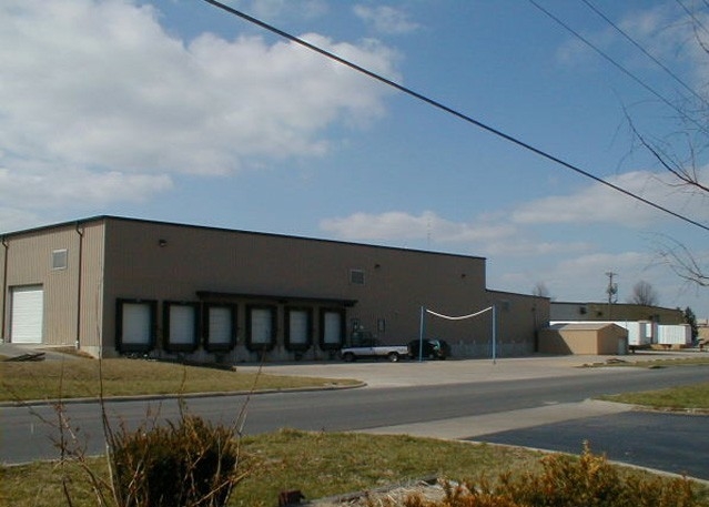
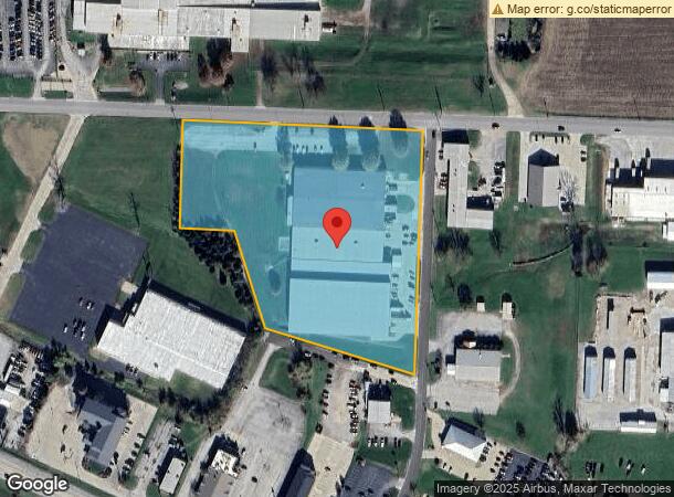
Property Record
3509 W Main St, Sedalia, MO 65301

NEARBY LISTINGS FOR SALE OR LEASE
Property Detail
3509 W Main St
Sedalia, MO
BEG S LI W MAIN ST 464.61' E OF W LI LOT2 NE, E 1126' S 1081' NWLY 468.03' NWLY 298.78' W 150' N 300' 6 45 21
153006102004000
Pettis
Commercialnec
Missouri
2023
8.90 AC
2023
Missouri North Area
480700
Other Market Areas
121,058 SF
DEMOGRAPHICS near 3509 W Main St
1 Mile
3 Mile
5 Mile
2024 Total Population
2,015
18,498
30,123
2029 Population
2,044
18,948
30,857
Pop Growth 2024-2029
+ 1.44%
+ 2.43%
+ 2.44%
Average Age
46
39
39
2024 Total Households
939
7,544
12,019
HH Growth 2024-2029
+ 1.81%
+ 2.52%
+ 2.48%
Median Household Inc
$48,863
$53,095
$51,743
Avg Household Size
2.00
2.30
2.40
2024 Avg HH Vehicles
1.00
2.00
2.00
Median Home Value
$242,405
$144,480
$141,442
Median Year Built
1997
1966
1969
Nearby Places
- Restaurants
- Banks
- Shops
- Fitness
- Groceries
PUBLIC TRANSPORTATION
COMMUTER RAIL
Sedalia Amtrak Station (Lincoln Service Missouri River Runner - Amtrak, Missouri River Runner - Amtrak)
DRIVE
WALK
Distance
Sedalia Amtrak Station (Lincoln Service Missouri River Runner - Amtrak, Missouri River Runner - Amtrak)
6 min
2.5 mi
Freight Ports
Tulsa Port Of Catoosa
DRIVE
WALK
Distance
Tulsa Port Of Catoosa
315 min
273.1 mi
SALE & LEASE HISTORY
LISTING DATE
SALE/LEASE

Sep 24, 2016
For Sale
May 11, 2018
For Lease
May 11, 2017
For Sale
May 09, 2017
For Lease
Nearby Properties
Address
Land Use
TOTAL SIZE
Lot Size
Zoning
Address
Land Use
TOTAL SIZE
Lot Size
Zoning
202,974 SF
15.87 AC
Address
Land Use
TOTAL SIZE
Lot Size
Zoning
Address
Land Use
TOTAL SIZE
Lot Size
Zoning
52,605 SF
26.56 AC
Address
Land Use
TOTAL SIZE
Lot Size
Zoning
201,452 SF
15 AC
Address
Land Use
TOTAL SIZE
Lot Size
Zoning
494,190 SF
45.23 AC
Address
Land Use
TOTAL SIZE
Lot Size
Zoning
121,591 SF
15.30 AC
Address
Land Use
TOTAL SIZE
Lot Size
Zoning
69,763 SF
9.96 AC
Address
Land Use
TOTAL SIZE
Lot Size
Zoning
440,184 SF
26 AC
Address
Land Use
TOTAL SIZE
Lot Size
Zoning
49,341 SF
3.37 AC
Address
Land Use
TOTAL SIZE
Lot Size
Zoning
303,444 SF
40.75 AC
Address
Land Use
TOTAL SIZE
Lot Size
Zoning
55,464 SF
5.60 AC
Address
Land Use
TOTAL SIZE
Lot Size
Zoning
223,284 SF
38.25 AC
Address
Land Use
TOTAL SIZE
Lot Size
Zoning
13,158 SF
9.20 AC
Address
Land Use
TOTAL SIZE
Lot Size
Zoning
60,173 SF
3.85 AC
Address
Land Use
TOTAL SIZE
Lot Size
Zoning
11,149 SF
3.81 AC
Address
Land Use
TOTAL SIZE
Lot Size
Zoning
41,130 SF
2 AC
Address
Land Use
TOTAL SIZE
Lot Size
Zoning
8,699 SF
0.70 AC
Address
Land Use
TOTAL SIZE
Lot Size
Zoning
108,294 SF
12.31 AC
Address
Land Use
TOTAL SIZE
Lot Size
Zoning
8,700 SF
6.62 AC
Address
Land Use
TOTAL SIZE
Lot Size
Zoning
91,564 SF
4.58 AC
Address
Land Use
TOTAL SIZE
Lot Size
Zoning
22,950 SF
3.34 AC
Address
Land Use
TOTAL SIZE
Lot Size
Zoning
12,060 SF
13.94 AC
Address
Land Use
TOTAL SIZE
Lot Size
Zoning
66,046 SF
2.25 AC
Address
Land Use
TOTAL SIZE
Lot Size
Zoning
48,410 SF
1.84 AC
Address
Land Use
TOTAL SIZE
Lot Size
Zoning
53,209 SF
3.29 AC
Address
Land Use
TOTAL SIZE
Lot Size
Zoning
52,400 SF
4.74 AC
Address
Land Use
TOTAL SIZE
Lot Size
Zoning
2,800 SF
171.52 AC
Address
Land Use
TOTAL SIZE
Lot Size
Zoning
14,190 SF
1.58 AC
Address
Land Use
TOTAL SIZE
Lot Size
Zoning
41,054 SF
10.74 AC
Address
Land Use
TOTAL SIZE
Lot Size
Zoning
32,640 SF
2.17 AC
The World's #1 Commercial Real Estate Marketplace
Connect with us
© 2025 CoStar Group
The information above has been obtained from sources believed reliable. While we do not doubt its accuracy we have not verified it and make no guarantee, warranty or representation about it. It is your responsibility to independently confirm its accuracy and completeness. Any projections, opinions, assumptions, or estimates used are for example only and do not represent the current or future performance of the property. The value of this transaction to you depends on tax and other factors which should be evaluated by your tax, financial, and legal advisors. You and your advisors should conduct a careful, independent investigation of the property to determine to your satisfaction the suitability of the property for your needs.