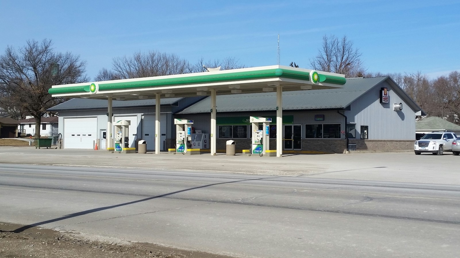
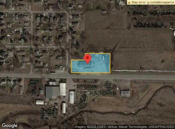
Property Record
351 6Th St, Manning, IA 51455
NEARBY LISTINGS FOR SALE OR LEASE
-
-
View all Manning listings for lease on LoopNet.com
Property Detail
351 6Th St
Carroll, IA
Pt Of Irr Sur Se Se & Gardner's Addition
13-17-481-008
17-82-36 PT OF IRR SUR SE SE & GARDNER'S ADDITION BLK 7, S 27' OF LOT 1 & LOT 2 EXC S 17' BEG 50 FT N OF SW COR OF SE SE, N 200 FT, E 260 FT, S 200 F T, WW 260 FT TO BEG
Commercialnec
Carroll
A
Iowa
19047C0450D
1,2
2024
1.60 AC
2024
Iowa West Area
960600
Other Market Areas
4,093 SF
DEMOGRAPHICS near 351 6Th St
1 Mile
3 Mile
5 Mile
2024 Total Population
1,623
1,754
2,024
2029 Population
1,639
1,765
2,021
Pop Growth 2024-2029
+ 0.99%
+ 0.63%
(0.15%)
Average Age
43
43
43
2024 Total Households
730
787
897
HH Growth 2024-2029
+ 0.96%
+ 0.64%
(0.11%)
Median Household Inc
$62,301
$63,515
$66,371
Avg Household Size
2.20
2.20
2.20
2024 Avg HH Vehicles
2.00
2.00
2.00
Median Home Value
$115,051
$119,286
$128,333
Median Year Built
1953
1952
1951
Nearby Places
- Restaurants
- Banks
- Shops
- Fitness
- Groceries
SALE & LEASE HISTORY
LISTING DATE
SALE/LEASE

Sep 25, 2016
For Lease
Nearby Properties
Address
Land Use
TOTAL SIZE
Lot Size
Zoning
Address
Land Use
TOTAL SIZE
Lot Size
Zoning
4,000 SF
38.10 AC
Address
Land Use
TOTAL SIZE
Lot Size
Zoning
28,668 SF
2.10 AC
Address
Land Use
TOTAL SIZE
Lot Size
Zoning
18,820 SF
1.20 AC
Address
Land Use
TOTAL SIZE
Lot Size
Zoning
1,624 SF
2 AC
Address
Land Use
TOTAL SIZE
Lot Size
Zoning
1,939 SF
6.60 AC
Address
Land Use
TOTAL SIZE
Lot Size
Zoning
15,450 SF
3.50 AC
Address
Land Use
TOTAL SIZE
Lot Size
Zoning
9,224 SF
1.50 AC
Address
Land Use
TOTAL SIZE
Lot Size
Zoning
14,460 SF
2.50 AC
Address
Land Use
TOTAL SIZE
Lot Size
Zoning
14,285 SF
0.20 AC
Address
Land Use
TOTAL SIZE
Lot Size
Zoning
10,261 SF
1 AC
Address
Land Use
TOTAL SIZE
Lot Size
Zoning
1,102 SF
3.10 AC
Address
Land Use
TOTAL SIZE
Lot Size
Zoning
4,500 SF
2.20 AC
Address
Land Use
TOTAL SIZE
Lot Size
Zoning
5,392 SF
0.30 AC
Address
Land Use
TOTAL SIZE
Lot Size
Zoning
8,400 SF
2.60 AC
Address
Land Use
TOTAL SIZE
Lot Size
Zoning
576 SF
2.30 AC
Address
Land Use
TOTAL SIZE
Lot Size
Zoning
7,500 SF
3.20 AC
Address
Land Use
TOTAL SIZE
Lot Size
Zoning
5,900 SF
4.10 AC
Address
Land Use
TOTAL SIZE
Lot Size
Zoning
6,865 SF
0.40 AC
Address
Land Use
TOTAL SIZE
Lot Size
Zoning
2,618 SF
0.20 AC
Address
Land Use
TOTAL SIZE
Lot Size
Zoning
6,900 SF
1.10 AC
Address
Land Use
TOTAL SIZE
Lot Size
Zoning
32,200 SF
5.90 AC
Address
Land Use
TOTAL SIZE
Lot Size
Zoning
5,568 SF
0.50 AC
Address
Land Use
TOTAL SIZE
Lot Size
Zoning
16.10 AC
Address
Land Use
TOTAL SIZE
Lot Size
Zoning
400 SF
37.20 AC
Address
Land Use
TOTAL SIZE
Lot Size
Zoning
6,480 SF
2.80 AC
Address
Land Use
TOTAL SIZE
Lot Size
Zoning
432 SF
2.80 AC
Address
Land Use
TOTAL SIZE
Lot Size
Zoning
3,600 SF
0.30 AC
Address
Land Use
TOTAL SIZE
Lot Size
Zoning
10,464 SF
1.50 AC
Address
Land Use
TOTAL SIZE
Lot Size
Zoning
4,037 SF
0.10 AC
The World's #1 Commercial Real Estate Marketplace
Connect with us
© 2025 CoStar Group
The information above has been obtained from sources believed reliable. While we do not doubt its accuracy we have not verified it and make no guarantee, warranty or representation about it. It is your responsibility to independently confirm its accuracy and completeness. Any projections, opinions, assumptions, or estimates used are for example only and do not represent the current or future performance of the property. The value of this transaction to you depends on tax and other factors which should be evaluated by your tax, financial, and legal advisors. You and your advisors should conduct a careful, independent investigation of the property to determine to your satisfaction the suitability of the property for your needs.