Property Record
3422 S 84Th St S, Lakewood, WA 98499

NEARBY LISTINGS FOR SALE OR LEASE
Property Detail
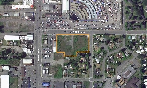
3422 S 84Th St S
032031-2075
SECTION 31 TOWNSHIP 20 RANGE 03 QUARTER 23 : COM ON W LI OF SEC 1056 FT N OF SW COR OF LOT 2 TH E PAR TO S LI OF SD LOT 235 FT TO POB TH CONT E ALG SAME COURSE 95 FT TH S 55 FT TH E 165 FT TH N 55 FT TH E 165 FT TH N PAR TO W LI OF SD LOT 237.34 FT M
Commercialacreage
Pierce
X
Washington
53053C0311E
2
2024
2.51 AC
2025
Univ. Place/Lakewood
071807
Seattle/Puget Sound
1 SF
Seattle-Tacoma-Bellevue, WA
DEMOGRAPHICS near 3422 S 84Th St S
1 Mile
3 Mile
5 Mile
2024 Total Population
11,768
128,477
296,093
2029 Population
12,170
132,865
306,308
Pop Growth 2024-2029
+ 3.42%
+ 3.42%
+ 3.45%
Average Age
35
37
38
2024 Total Households
4,395
48,971
112,684
HH Growth 2024-2029
+ 3.55%
+ 3.50%
+ 3.55%
Median Household Inc
$58,760
$63,334
$69,162
Avg Household Size
2.60
2.50
2.50
2024 Avg HH Vehicles
2.00
2.00
2.00
Median Home Value
$290,467
$367,838
$402,674
Median Year Built
1976
1976
1975
Nearby Places
Map Layers
Map Styles
 Street
 Aerial
- Restaurants
- Banks
- Shops
- Fitness
- Groceries
PUBLIC TRANSPORTATION
COMMUTER RAIL
DRIVE
WALK
Distance
4 min
1.8 mi
DRIVE
WALK
Distance
6 min
2.4 mi
AIRPORT
Seattle-Tacoma International
DRIVE
WALK
Distance
Seattle-Tacoma International
41 min
26.6 mi
Freight Ports
Port of Tacoma
DRIVE
WALK
Distance
Port of Tacoma
14 min
8.1 mi
Nearby Properties
Address
Land Use
TOTAL SIZE
Lot Size
Zoning
Address
Land Use
TOTAL SIZE
Lot Size
Zoning
515,971 SF
42.45 AC
Address
Land Use
TOTAL SIZE
Lot Size
Zoning
566,355 SF
69.03 AC
Address
Land Use
TOTAL SIZE
Lot Size
Zoning
1,056,518 SF
65.31 AC
LKWD
Address
Land Use
TOTAL SIZE
Lot Size
Zoning
309,156 SF
33.79 AC
M2
Address
Land Use
TOTAL SIZE
Lot Size
Zoning
296,154 SF
46.83 AC
R2
Address
Land Use
TOTAL SIZE
Lot Size
Zoning
238,852 SF
15.34 AC
OSR1
Address
Land Use
TOTAL SIZE
Lot Size
Zoning
211,786 SF
16.84 AC
MF2
Address
Land Use
TOTAL SIZE
Lot Size
Zoning
199,208 SF
6.82 AC
MF3
Address
Land Use
TOTAL SIZE
Lot Size
Zoning
254,934 SF
5.02 AC
MF
Address
Land Use
TOTAL SIZE
Lot Size
Zoning
140,287 SF
12.95 AC
MF2
Address
Land Use
TOTAL SIZE
Lot Size
Zoning
162,000 SF
9.93 AC
Address
Land Use
TOTAL SIZE
Lot Size
Zoning
378,996 SF
34.43 AC
MHR
Address
Land Use
TOTAL SIZE
Lot Size
Zoning
125,725 SF
9.17 AC
MF2
Address
Land Use
TOTAL SIZE
Lot Size
Zoning
393,488 SF
15.58 AC
MHR
Address
Land Use
TOTAL SIZE
Lot Size
Zoning
149,364 SF
35.69 AC
PI
Address
Land Use
TOTAL SIZE
Lot Size
Zoning
124,308 SF
9.38 AC
PI
Address
Land Use
TOTAL SIZE
Lot Size
Zoning
128,914 SF
16.03 AC
Address
Land Use
TOTAL SIZE
Lot Size
Zoning
267,056 SF
39.14 AC
PI
Address
Land Use
TOTAL SIZE
Lot Size
Zoning
61.20 AC
M2
Address
Land Use
TOTAL SIZE
Lot Size
Zoning
190,976 SF
6.49 AC
R4L
Address
Land Use
TOTAL SIZE
Lot Size
Zoning
160,514 SF
15.61 AC
MF2
Address
Land Use
TOTAL SIZE
Lot Size
Zoning
273,816 SF
12.03 AC
Address
Land Use
TOTAL SIZE
Lot Size
Zoning
293,624 SF
21.16 AC
IBP
Address
Land Use
TOTAL SIZE
Lot Size
Zoning
169,397 SF
18.65 AC
CBD
Address
Land Use
TOTAL SIZE
Lot Size
Zoning
133,660 SF
6.79 AC
MF
Address
Land Use
TOTAL SIZE
Lot Size
Zoning
245,958 SF
12.29 AC
Address
Land Use
TOTAL SIZE
Lot Size
Zoning
35,532 SF
1.51 AC
UCX
Address
Land Use
TOTAL SIZE
Lot Size
Zoning
266,208 SF
12.32 AC
LKWD
Address
Land Use
TOTAL SIZE
Lot Size
Zoning
187,937 SF
25 AC
C3
Address
Land Use
TOTAL SIZE
Lot Size
Zoning
121,400 SF
8.45 AC
R2
The World's #1 Commercial Real Estate Marketplace
Connect with us
© 2026 CoStar Group
The information above has been obtained from sources believed reliable. While we do not doubt its accuracy we have not verified it and make no guarantee, warranty or representation about it. It is your responsibility to independently confirm its accuracy and completeness. Any projections, opinions, assumptions, or estimates used are for example only and do not represent the current or future performance of the property. The value of this transaction to you depends on tax and other factors which should be evaluated by your tax, financial, and legal advisors. You and your advisors should conduct a careful, independent investigation of the property to determine to your satisfaction the suitability of the property for your needs.