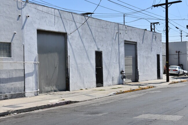
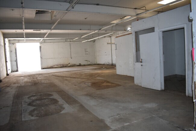
Property Record
3517 Union Pacific Ave, Los Angeles, CA 90023
NEARBY LISTINGS FOR SALE OR LEASE
Property Detail
3517 Union Pacific Ave
Los Angeles-Long Beach-Glendale, CA
5030
5191-022-021
TRACT # 5030 LOT 145
Lightindustrial
Los Angeles
X
California
06037C1639F
145
2024
0.10 AC
2025
Vernon
204920
Los Angeles
3,200 SF
DEMOGRAPHICS near 3517 Union Pacific Ave
1 Mile
3 Mile
5 Mile
2024 Total Population
22,399
263,772
890,868
2029 Population
21,374
250,416
851,448
Pop Growth 2024-2029
(4.58%)
(5.06%)
(4.42%)
Average Age
35
36
37
2024 Total Households
5,738
71,048
263,979
HH Growth 2024-2029
(4.98%)
(5.32%)
(4.25%)
Median Household Inc
$48,782
$53,192
$53,408
Avg Household Size
3.70
3.50
3.10
2024 Avg HH Vehicles
2.00
2.00
2.00
Median Home Value
$651,133
$605,944
$647,417
Median Year Built
1948
1951
1956
Nearby Places
Map Layers
Map Styles
 Street
 Aerial
- Restaurants
- Banks
- Shops
- Fitness
- Groceries
PUBLIC TRANSPORTATION
COMMUTER RAIL
DRIVE
WALK
Distance
9 min
4.2 mi
Union Station (91 Line - Southern California Regional Rail Authority (Metrolink), Antelope Valley Line - Southern California Regional Rail Authority (Metrolink), Orange County Line - Southern California Regional Rail Authority (Metrolink), Riverside Line - Southern California Regional Rail Authority (Metrolink), San Bernardino Line - Southern California Regional Rail Authority (Metrolink), Ventura County Line - Southern California Regional Rail Authority (Metrolink))
DRIVE
WALK
Distance
Union Station (91 Line - Southern California Regional Rail Authority (Metrolink), Antelope Valley Line - Southern California Regional Rail Authority (Metrolink), Orange County Line - Southern California Regional Rail Authority (Metrolink), Riverside Line - Southern California Regional Rail Authority (Metrolink), San Bernardino Line - Southern California Regional Rail Authority (Metrolink), Ventura County Line - Southern California Regional Rail Authority (Metrolink))
11 min
4.4 mi
AIRPORT
Los Angeles International
DRIVE
WALK
Distance
Los Angeles International
31 min
18.6 mi
Long Beach (Daugherty Field)
DRIVE
WALK
Distance
Long Beach (Daugherty Field)
28 min
19.1 mi
Bob Hope
DRIVE
WALK
Distance
Bob Hope
30 min
19.9 mi
Freight Ports
Port of Long Beach
DRIVE
WALK
Distance
Port of Long Beach
30 min
21.0 mi
SALE & LEASE HISTORY
LISTING DATE
SALE/LEASE

Jul 07, 2022
For Lease
Feb 10, 2017
For Lease
Apr 09, 2020
For Lease
Nearby Properties
Address
Land Use
TOTAL SIZE
Lot Size
Zoning
Address
Land Use
TOTAL SIZE
Lot Size
Zoning
2,697,158 SF
20.18 AC
LAM2
Address
Land Use
TOTAL SIZE
Lot Size
Zoning
635,233 SF
12.02 AC
LAR5
Address
Land Use
TOTAL SIZE
Lot Size
Zoning
444,139 SF
3.63 AC
LAM3
Address
Land Use
TOTAL SIZE
Lot Size
Zoning
479,272 SF
16.14 AC
LAM3
Address
Land Use
TOTAL SIZE
Lot Size
Zoning
1,088,170 SF
15.98 AC
LAM3
Address
Land Use
TOTAL SIZE
Lot Size
Zoning
535,949 SF
5.85 AC
LAM3
Address
Land Use
TOTAL SIZE
Lot Size
Zoning
327,061 SF
2.18 AC
LAM3
Address
Land Use
TOTAL SIZE
Lot Size
Zoning
322,080 SF
2.85 AC
LAC2
Address
Land Use
TOTAL SIZE
Lot Size
Zoning
182,700 SF
8.29 AC
LAM3
Address
Land Use
TOTAL SIZE
Lot Size
Zoning
271,020 SF
18.93 AC
CMM2*
Address
Land Use
TOTAL SIZE
Lot Size
Zoning
693,282 SF
30.34 AC
CMM2*
Address
Land Use
TOTAL SIZE
Lot Size
Zoning
397,866 SF
3.51 AC
LAM3
Address
Land Use
TOTAL SIZE
Lot Size
Zoning
227,179 SF
10.46 AC
VEM*
Address
Land Use
TOTAL SIZE
Lot Size
Zoning
527,173 SF
12.36 AC
CMM2*
Address
Land Use
TOTAL SIZE
Lot Size
Zoning
276,452 SF
1.21 AC
LAM3
Address
Land Use
TOTAL SIZE
Lot Size
Zoning
557,445 SF
14.08 AC
CMM2YY
Address
Land Use
TOTAL SIZE
Lot Size
Zoning
326,472 SF
14.53 AC
VEM*
Address
Land Use
TOTAL SIZE
Lot Size
Zoning
188,319 SF
11.25 AC
VEM&MS1*
Address
Land Use
TOTAL SIZE
Lot Size
Zoning
318,388 SF
11.07 AC
LAM2
Address
Land Use
TOTAL SIZE
Lot Size
Zoning
104,676 SF
4.32 AC
LAM3
Address
Land Use
TOTAL SIZE
Lot Size
Zoning
Address
Land Use
TOTAL SIZE
Lot Size
Zoning
251,338 SF
10.62 AC
LAM3
Address
Land Use
TOTAL SIZE
Lot Size
Zoning
841,076 SF
23.77 AC
CMM2*
Address
Land Use
TOTAL SIZE
Lot Size
Zoning
330,904 SF
12.09 AC
VEM*
Address
Land Use
TOTAL SIZE
Lot Size
Zoning
260,714 SF
9.99 AC
VEM*
Address
Land Use
TOTAL SIZE
Lot Size
Zoning
7.02 AC
LAM3
Address
Land Use
TOTAL SIZE
Lot Size
Zoning
116,728 SF
0.86 AC
HPCP*
Address
Land Use
TOTAL SIZE
Lot Size
Zoning
372,634 SF
10.83 AC
VEM*
Address
Land Use
TOTAL SIZE
Lot Size
Zoning
303,030 SF
7.14 AC
CMM2-M1*
Address
Land Use
TOTAL SIZE
Lot Size
Zoning
369,554 SF
8.49 AC
VEM*
The World's #1 Commercial Real Estate Marketplace
Connect with us
© 2026 CoStar Group
The information above has been obtained from sources believed reliable. While we do not doubt its accuracy we have not verified it and make no guarantee, warranty or representation about it. It is your responsibility to independently confirm its accuracy and completeness. Any projections, opinions, assumptions, or estimates used are for example only and do not represent the current or future performance of the property. The value of this transaction to you depends on tax and other factors which should be evaluated by your tax, financial, and legal advisors. You and your advisors should conduct a careful, independent investigation of the property to determine to your satisfaction the suitability of the property for your needs.