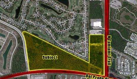
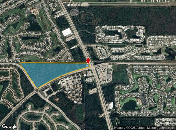
Property Record
3561 De Navarra Pkwy, Cape Coral, FL 33909
NEARBY LISTINGS FOR SALE OR LEASE
Property Detail
3561 De Navarra Pkwy
Cape Coral-Fort Myers, FL
Cape Coral
21-43-24-C2-00001.0000
PORTION OF LAND LYING IN CAPE CORAL UNIT 86 AS DESC IN INSTRUMENT 2024000139853
Timberlandforesttreesagricultural
Lee
X
Florida
12071C0260G
41.20 AC
2023
Cape Coral
2024
Southwest Florida
010203
DEMOGRAPHICS near 3561 De Navarra Pkwy
1 Mile
3 Mile
5 Mile
2024 Total Population
6,706
37,938
85,866
2029 Population
8,135
45,423
102,395
Pop Growth 2024-2029
+ 21.31%
+ 19.73%
+ 19.25%
Average Age
56
53
48
2024 Total Households
3,209
17,531
36,923
HH Growth 2024-2029
+ 20.66%
+ 19.13%
+ 18.76%
Median Household Inc
$59,487
$53,668
$55,464
Avg Household Size
2.10
2.10
2.20
2024 Avg HH Vehicles
1.00
2.00
2.00
Median Home Value
$196,880
$132,651
$184,864
Median Year Built
1999
1990
1990
Nearby Places
- Restaurants
- Banks
- Shops
- Fitness
- Groceries
PUBLIC TRANSPORTATION
AIRPORT
Punta Gorda
DRIVE
WALK
Distance
Punta Gorda
24 min
16.7 mi
Southwest Florida International
DRIVE
WALK
Distance
Southwest Florida International
32 min
19.9 mi
Freight Ports
Port Manatee
DRIVE
WALK
Distance
Port Manatee
103 min
88.4 mi
SALE & LEASE HISTORY
LISTING DATE
SALE/LEASE

Sep 24, 2016
For Sale
Nearby Properties
Address
Land Use
TOTAL SIZE
Lot Size
Zoning
Address
Land Use
TOTAL SIZE
Lot Size
Zoning
214,515 SF
30.60 AC
I-1
Address
Land Use
TOTAL SIZE
Lot Size
Zoning
262,258 SF
52.71 AC
INS
Address
Land Use
TOTAL SIZE
Lot Size
Zoning
209,881 SF
63.03 AC
AG-2
Address
Land Use
TOTAL SIZE
Lot Size
Zoning
1,666 SF
35.55 AC
AG-2
Address
Land Use
TOTAL SIZE
Lot Size
Zoning
451,348 SF
21.43 AC
CPD
Address
Land Use
TOTAL SIZE
Lot Size
Zoning
112,356 SF
18.99 AC
AG-2
Address
Land Use
TOTAL SIZE
Lot Size
Zoning
51,478 SF
68.97 AC
C-2
Address
Land Use
TOTAL SIZE
Lot Size
Zoning
107,321 SF
3.84 AC
C-1A
Address
Land Use
TOTAL SIZE
Lot Size
Zoning
90 AC
C-2
Address
Land Use
TOTAL SIZE
Lot Size
Zoning
79,253 SF
11.47 AC
C-3
Address
Land Use
TOTAL SIZE
Lot Size
Zoning
72,683 SF
9.82 AC
CPD
Address
Land Use
TOTAL SIZE
Lot Size
Zoning
48,780 SF
14.99 AC
Address
Land Use
TOTAL SIZE
Lot Size
Zoning
59,736 SF
14.91 AC
C-2
Address
Land Use
TOTAL SIZE
Lot Size
Zoning
29,909 SF
3.47 AC
AG-2
Address
Land Use
TOTAL SIZE
Lot Size
Zoning
106,615 SF
4.51 AC
C1-A
Address
Land Use
TOTAL SIZE
Lot Size
Zoning
632.90 AC
NZ
Address
Land Use
TOTAL SIZE
Lot Size
Zoning
106.20 AC
RPD
Address
Land Use
TOTAL SIZE
Lot Size
Zoning
114,719 SF
13.64 AC
C-3
Address
Land Use
TOTAL SIZE
Lot Size
Zoning
12,285 SF
1.42 AC
C-3
Address
Land Use
TOTAL SIZE
Lot Size
Zoning
16,036 SF
1.80 AC
CPD
Address
Land Use
TOTAL SIZE
Lot Size
Zoning
158,197 SF
11.15 AC
CPD
Address
Land Use
TOTAL SIZE
Lot Size
Zoning
60.06 AC
I-1
Address
Land Use
TOTAL SIZE
Lot Size
Zoning
16,008 SF
2.43 AC
C-1
Address
Land Use
TOTAL SIZE
Lot Size
Zoning
61,461 SF
199.30 AC
RPD
Address
Land Use
TOTAL SIZE
Lot Size
Zoning
44,305 SF
4.51 AC
C1
Address
Land Use
TOTAL SIZE
Lot Size
Zoning
44,836 SF
22.50 AC
AG-2
Address
Land Use
TOTAL SIZE
Lot Size
Zoning
53.88 AC
I-1
Address
Land Use
TOTAL SIZE
Lot Size
Zoning
16.68 AC
C-1A
Address
Land Use
TOTAL SIZE
Lot Size
Zoning
99.92 AC
RPD
Address
Land Use
TOTAL SIZE
Lot Size
Zoning
66.91 AC
NC
The World's #1 Commercial Real Estate Marketplace
Connect with us
© 2025 CoStar Group
The information above has been obtained from sources believed reliable. While we do not doubt its accuracy we have not verified it and make no guarantee, warranty or representation about it. It is your responsibility to independently confirm its accuracy and completeness. Any projections, opinions, assumptions, or estimates used are for example only and do not represent the current or future performance of the property. The value of this transaction to you depends on tax and other factors which should be evaluated by your tax, financial, and legal advisors. You and your advisors should conduct a careful, independent investigation of the property to determine to your satisfaction the suitability of the property for your needs.